| . |  |
. |
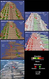
Through a cooperative research program NASA, the U.S. Geological Survey and the U.S. Army Corps of Engineers are exploring the use of innovative airborne laser mapping systems to quantify coastal change along the entire coastline affected by Hurricane Katrina. Elevation data from these research instruments acquired before and after the hurricane are compared to determine the patterns and magnitudes of coastal change caused by erosion and destruction of buildings and infrastructure. Three lidar surveys were collected using two different systems. The systems were NASA's Experimental Airborne Research Lidar (EAARL) and Army Corps of Engineers' Compact Hydrographic Airborne Rapid Total Survey (CHARTS). The impact of Hurricane Katrina was observed on Dauphin Island. Dauphin Island is a barrier island approximately 90 miles from where the storm made landfall. Storm surge inundated the island and waves transported sand landward into fan-shaped deposits shifting the entire island toward the coastline. A number of houses, depicted in the lidar difference plots as red rectangles, were destroyed. NASA has created a series of animations comparing the differences between the before and after elevation data sets that represent findings from the research on how major storm events can impact and change coastal areas. Related Links SpaceDaily Search SpaceDaily Subscribe To SpaceDaily Express Orbimage announced Friday that it had entered into a definitive agreement to acquire the assets of Space Imaging. Under the asset purchase agreement, Orbimage will acquire substantially all of the assets of Space Imaging.
|
| ||||||||||
| The content herein, unless otherwise known to be public domain, are Copyright 1995-2016 - Space Media Network. All websites are published in Australia and are solely subject to Australian law and governed by Fair Use principals for news reporting and research purposes. AFP, UPI and IANS news wire stories are copyright Agence France-Presse, United Press International and Indo-Asia News Service. ESA news reports are copyright European Space Agency. All NASA sourced material is public domain. Additional copyrights may apply in whole or part to other bona fide parties. Advertising does not imply endorsement, agreement or approval of any opinions, statements or information provided by Space Media Network on any Web page published or hosted by Space Media Network. Privacy Statement All images and articles appearing on Space Media Network have been edited or digitally altered in some way. Any requests to remove copyright material will be acted upon in a timely and appropriate manner. Any attempt to extort money from Space Media Network will be ignored and reported to Australian Law Enforcement Agencies as a potential case of financial fraud involving the use of a telephonic carriage device or postal service. |