| . |  |
. |
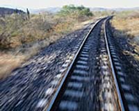
European researchers have developed an innovative satellite-based control and command system for low-density railway lines that could herald a minor revolution in train transportation management. The IST-funded LOCOPROL project, which officially ended in January 2005, set out to harness advances in satellite technology to save costs and maximise efficiency in the management of low-density traffic lines (LTDL). The project achieved all of its main objectives and has sparked considerable interest among many European and global railway operators, according to project coordinator, Michel Rousseau. "There is a real need for this technology. Existing command-control systems adapted for medium traffic density lines or the future ERTMS/ETCS (European Rail Traffic Management System/ European Train Control System) system dedicated to high speed and/or high-density traffic railway lines are too expensive to be used on railway lines with low and very low traffic density," he says. He notes that as a consequence, many LDTL in the European Union, Eastern Europe, the United States and in developing countries all over the world are still equipped with ageing and dangerous human-based safety equipment with high maintenance costs, keeping the capacity of these lines to a very low threshold. "We saw the need to develop an innovative and cost-effective system for low-density traffic lines based on new available technologies such as satellite location. The concept is to offer the same level of safety as high-density lines and enhancing the efficiency of these lines in order for rail transport to become more attractive," he says.
LOCOPROL's driving aims The LOCOPROL project set out with four key objectives. Firstly, to define a new multi-technology location system based on satellite positioning combined with failsafe onboard track mapping and interlocking. Then to study and prove the system's applicability in LDTL lines and also in ERTMS/ETCS lines. Finally, LOCOPROL wanted to study and prove the application of the new system in terms of track workers' security and safety. A new sensor configuration developed by LOCOPROL was implemented and successfully tested in two test tracks in Belgium and in France during the duration of the project, says Rousseau. "This new train borne sensor configuration underscores the added value of the introduction of satellite-based positioning. The new sensor allows a reduction of the amount of sensors compared to what is typically used today and particularly the very expensive sensors in terms of life cycle cost," he says. Satellite-based positioning is the heart of the LOCOPROL system, emphasises Rousseau. An innovative positioning algorithm has been developed to provide train-borne signalling equipment with a failsafe interval of the train position (called confidence interval), by making use of satellite range signals coming from a GNSS receiver. This algorithm is called the '1D algorithm' as it uses one of the particular characteristics of the rail transport: its one degree of freedom movement.
Under trial The most recent tests carried out on the Gembloux-Jemeppe link in Belgium, a typical low-density line in a hilly environment with varying satellite visibility, were devoted to the 1D satellite positioning sub-system, intended to be used as the means to locate the trains in the failsafe LOCOPROL signalling system. During the Belgian trial, the 1D algorithm was tested in stringent real-life conditions. The tests first aimed at debugging the software, identifying potential problems while running it in a real environment. "The tests demonstrated that the combination of wheel sensors and GNSS sensors associated with the 1D algorithm developed in the frame of the project allows a level of performance at least compatible with LDTL requirements at a significantly reduced life cycle cost," says Rousseau. The beauty of the system is that the level of safety will be the same as on high-density lines, while the efficiency of these LDTL will be enhanced through reductions in operating and maintenance costs, helping to make railway transport more attractive, he says. Another bonus is the fact that the system can be readily upgraded to cope with increased traffic or other signalling changes on a line. In its basic configuration as implemented in the Nice-Digne line in France, the equipment is limited to the control centre and to the train-borne equipment, thereby limiting the trackside equipment to passive balises, transponders used in non-continuous automatic train protection systems, in the station and marker boards. In order to increase the performance of the line, the points can be upgraded with control or command sub-systems that can be controlled by the LOCOPROL system through an object controller installed in the station. In the same way, level crossing control can be handled by the LOCOPROL system, points out Rousseau. "As a global solution, the system can migrate in functionalities by integrating more complex traffic supervision, maintenance and information functions," he says. The feedback from railway operators involved in the trials was overwhelmingly positive about the possibilities for providing enhanced line safety and efficiency at lower costs with the LOCOPROL solution.
Strong commercial potential "The trials demonstrated that it is really possible to operate a low traffic density line with LOCOPROL," says Rousseau. "The availability of the system depends on the visibility of satellites. With GPS this availability is a little bit low in some areas but it is clear that the problem will be solved by the new GALILEO constellation working together with GNSS," he says. Another plus is that it should be possible to operate an ERTMS-equipped train on a LOCOPROL line by adding specific modules to take into account satellite location. "The system is also able to integrate other functionalities such as traffic management, trackside maintenance operations, and clients information," adds Rousseau. While a lot of technical details and standards still have to hammered out before LOCOPROL is ready for full commercialisation on an industrial scale, Rousseau has no doubt about the massive potential of the project's technology. "The market for LOCOPROL is characterised by single track lines with simple stations and a low density of traffic typically in the range of 1-2 trains per hour. Large opportunities for the system have been identified for freight, passenger and mixed lines," he says. Among freight networks, he cites the mining lines in South Africa and Brazil as potentially ripe for commercial exploitation, while passenger lines such as the secondary network in Nordic countries, Germany and the United Kingdom also hold exciting possibilities. "The lines in eastern European countries represent substantial potential as the infrastructures of these countries undergo modernisation. The strong growth in China and the consequent demand for a more efficient railway will also offer rich opportunities to exploit the LOCOPROL system," he ends. Related Links LOCOPROL project SpaceDaily Search SpaceDaily Subscribe To SpaceDaily Express 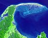 Greenbelt MD (SPX) Aug 17, 2005
On the northern tip of New Zealand's South Island, Farewell Spit stretches 30 kilometers eastward into the Tasman Sea from the Cape Farewell mainland. A sandy beach faces the open waters of the Tasman Sea, while an intricate wetland ecosystem faces south toward Golden Bay.
|
| ||||||||||
| The content herein, unless otherwise known to be public domain, are Copyright 1995-2016 - Space Media Network. All websites are published in Australia and are solely subject to Australian law and governed by Fair Use principals for news reporting and research purposes. AFP, UPI and IANS news wire stories are copyright Agence France-Presse, United Press International and Indo-Asia News Service. ESA news reports are copyright European Space Agency. All NASA sourced material is public domain. Additional copyrights may apply in whole or part to other bona fide parties. Advertising does not imply endorsement, agreement or approval of any opinions, statements or information provided by Space Media Network on any Web page published or hosted by Space Media Network. Privacy Statement All images and articles appearing on Space Media Network have been edited or digitally altered in some way. Any requests to remove copyright material will be acted upon in a timely and appropriate manner. Any attempt to extort money from Space Media Network will be ignored and reported to Australian Law Enforcement Agencies as a potential case of financial fraud involving the use of a telephonic carriage device or postal service. |