| . |  |
. |
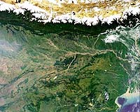
Starting Monday in Kathmandu, Nepal, ESA and the Governments of Austria and Switzerland and the United Nations Office for Outer Space Affairs (OOSA) are holding a five-day Workshop on Remote Sensing in the Service of Sustainable Development in Mountain Areas. It is the first in a new series of activities dedicated to sustainable development in mountain areas. The Workshop lasts from 15 to 19 November 2004, and is being hosted by the International Centre for Integrated Mountain Development (ICIMOD). Remotely-sensed data provides unique views of the Earth for many studies that require synoptic or periodic observations such as inventory, surveying and monitoring in agriculture, geology, hydrology, mineralogy and the environment. Remote sensing is integrated with other disciplines and technologies, including cartography and global positioning systems. The primary objective of the workshop, being inaugurated by the Minister for Population and Environment of Nepal, is to discuss the potential uses of remote sensing and other space-related technologies in facilitating sustainable development in mountain areas. The workshop programme includes case studies in the application of remote sensing to mountain areas. A number of interactive presentations will be delivered directly via satellite from Austria. A special event has been organised on ESA's Eduspace programme for educators from universities in Nepal. Around 150 scientists, educators, decision-makers and engineers are expected to participate, from the following countries and international organisations: Afghanistan, Armenia, Austria, Bangladesh, Bhutan, Cambodia, China, Denmark, India, Iran, Kyrgyzstan, Malaysia, Myanmar, Nepal, Pakistan, Philippines, Sri Lanka, Switzerland, Thailand, Viet Nam, United Nations Development Programme (UNDP), United Nations Institute for Training and Research (UNITAR), ICIMOD, ESA and OOSA. The United Nations Programme on Space Applications is implemented by the United Nations Office for Outer Space Affairs (OOSA) and works to improve the use of space science and technology for the economic and social development of all nations, in particular developing countries. Under the Programme, the Office conducts training courses, workshops, seminars and other activities on applications and capacity building in subjects such as remote sensing, communications, satellite meteorology, search and rescue, basic space science, satellite navigation and space law. ESA through its International Relations Department, is one of the major contributor to this UN Programme on Space Applications. The International Relations Department of ESA is responsible for relations with non-ESA member states in support to its space programmes. It is also responsible for promoting international cooperation in the peaceful uses of outer space, and assisting developing countries in using space applications, space science and technology. Related Links ICIMOD United Nations Office for Outer Space Affairs SpaceDaily Search SpaceDaily Subscribe To SpaceDaily Express 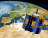 Paris, France (ESA) Nov 15, 2004
A new tool based on satellite data shows trends in the way Europeans use our landscape. Seen from the ground these changes appear gradual, but viewed from above they are often dramatic.
|
| ||||||||||
| The content herein, unless otherwise known to be public domain, are Copyright 1995-2016 - Space Media Network. All websites are published in Australia and are solely subject to Australian law and governed by Fair Use principals for news reporting and research purposes. AFP, UPI and IANS news wire stories are copyright Agence France-Presse, United Press International and Indo-Asia News Service. ESA news reports are copyright European Space Agency. All NASA sourced material is public domain. Additional copyrights may apply in whole or part to other bona fide parties. Advertising does not imply endorsement, agreement or approval of any opinions, statements or information provided by Space Media Network on any Web page published or hosted by Space Media Network. Privacy Statement All images and articles appearing on Space Media Network have been edited or digitally altered in some way. Any requests to remove copyright material will be acted upon in a timely and appropriate manner. Any attempt to extort money from Space Media Network will be ignored and reported to Australian Law Enforcement Agencies as a potential case of financial fraud involving the use of a telephonic carriage device or postal service. |