| . |  |
. |
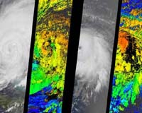
Seen through the eyes of the Multi-angle Imaging SpectroRadiometer aboard NASA's Terra satellite, the menacing clouds of Hurricanes Frances and Ivan provide a wealth of information that can help improve hurricane forecasts. The ability of forecasters to predict the intensity and amount of rainfall associated with hurricanes still requires improvement, particularly on the 24- to 48-hour timescales vital for disaster planning. Scientists need to better understand the complex interactions that lead to hurricane intensification and dissipation, and the various physical processes that affect hurricane intensity and rainfall distributions. Because uncertainties in representing hurricane cloud processes still exist, it is vital that model findings be evaluated against actual hurricane observations whenever possible. Two-dimensional maps of cloud heights such as those provided by the Multi-angle Imaging SpectroRadiometer offer an unprecedented opportunity for comparing simulated cloud fields against actual hurricane observations. The newly released images of Hurricanes Frances and Ivan were acquired Sept. 4 and Sept. 5, 2004, respectively, when Frances' eye sat just off the coast of eastern Florida and Ivan was heading toward the central and western Caribbean. They are available at: http://photojournal.jpl.nasa.gov/catalog/PIA04367. The left-hand panel in each image pair is a natural-color view from the instrument's nadir camera. The right-hand panels are computer-generated cloud-top height retrievals produced by comparing the features of images acquired at different view angles. When these images were acquired, clouds within Frances and Ivan had attained altitudes of 15 and 16 kilometers (9.3 and 9.9 miles) above sea level, respectively. The instrument is one of several Earth-observing experiments aboard Terra, launched in December 1999. The instrument acquires images of Earth at nine angles simultaneously, using nine separate cameras pointed forward, downward and backward along its flight path. It observes the daylit Earth continuously and every 9 days views the entire globe between 82 degrees north and 82 degrees south latitude. It was built and is managed by NASA's Jet Propulsion Laboratory, Pasadena, Calif. JPL is a division of the California Institute of Technology in Pasadena. Related Links MISR at JPL SpaceDaily Search SpaceDaily Subscribe To SpaceDaily Express 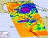 Pasadena CA (JPL) Sep 14, 2004
Hurricane Ivan is the most powerful hurricane to hit the Caribbean in 10 years. On September 7 and 8 it damaged 90 percent of the homes in Grenada and killed at least 16 people as it swept over Grenada, Barbados and the other islands in the area.
|
| ||||||||||
| The content herein, unless otherwise known to be public domain, are Copyright 1995-2016 - Space Media Network. All websites are published in Australia and are solely subject to Australian law and governed by Fair Use principals for news reporting and research purposes. AFP, UPI and IANS news wire stories are copyright Agence France-Presse, United Press International and Indo-Asia News Service. ESA news reports are copyright European Space Agency. All NASA sourced material is public domain. Additional copyrights may apply in whole or part to other bona fide parties. Advertising does not imply endorsement, agreement or approval of any opinions, statements or information provided by Space Media Network on any Web page published or hosted by Space Media Network. Privacy Statement All images and articles appearing on Space Media Network have been edited or digitally altered in some way. Any requests to remove copyright material will be acted upon in a timely and appropriate manner. Any attempt to extort money from Space Media Network will be ignored and reported to Australian Law Enforcement Agencies as a potential case of financial fraud involving the use of a telephonic carriage device or postal service. |