| . |  |
. |
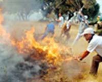
Last year's long hot summer was a bumper year for forest fires, with more than half a million hectares of woodland destroyed across Mediterranean Europe. So far this year fresh fires have occurred across Portugal, Spain and southern France, with 2500 people evacuated from blazes in foothills north of Marseille. According to the European Commission, each hectare of forest (1 hectare = 2.5 acres) lost to fire costs Europe's economy between a 1,000 and 5,000 Euros. The distinctive 'burn scars' left across the land by forest fires can be identified from space as a specific spectral signature from optical sensors in the short wavelength infrared, near infrared and visible channels. A new Earth Observation-based service is employing satellite imagery from SPOT and Landsat to automatically detect the 2004 burn scars within fire-prone areas of Southwest France, within the Puglia and Marche regions of Italy and across the full territory of Spain. Burn scar detection is planned to take place on a seasonal basis, identifying fires covering at least one hectare to a standard resolution of 30 metres, with detailed damage assessment available to a maximum resolution of 2.5 metres using the SPOT 5 satellite. Having been validated and geo-referenced, burn scar maps can then be easily merged with other relevant geographical detail in order to help identify correlations and decide where preventative measures should be prioritised. At the end of the risk mapping process, the probability of fire breaking out in a particular place and time can be reliably calculated. The Risk-EOS burn scar mapping service began last year. The intention is to develop further fire-related services by the end of 2007, including daily risk maps combining EO with meteorological and vegetation data. Another planned service will identify 'hot spots' during fires, and map fire events twice a day, permitting an overall assessment of its development and the damage being done. Related Links Space at European Commission SpaceDaily Search SpaceDaily Subscribe To SpaceDaily Express  Melbourne FL (SPX) Aug 13, 2004
Harris Corporation and DigitalGlobe announced Thursday that they will provide high-resolution, 3-D satellite imagery to NBC to support the network's coverage of the 2004 Olympics from Athens, Greece. Harris is using its ImageLinks TrueTerrain technology to enhance DigitalGlobe's satellite imagery of Athens.
|
| ||||||||||
| The content herein, unless otherwise known to be public domain, are Copyright 1995-2016 - Space Media Network. All websites are published in Australia and are solely subject to Australian law and governed by Fair Use principals for news reporting and research purposes. AFP, UPI and IANS news wire stories are copyright Agence France-Presse, United Press International and Indo-Asia News Service. ESA news reports are copyright European Space Agency. All NASA sourced material is public domain. Additional copyrights may apply in whole or part to other bona fide parties. Advertising does not imply endorsement, agreement or approval of any opinions, statements or information provided by Space Media Network on any Web page published or hosted by Space Media Network. Privacy Statement All images and articles appearing on Space Media Network have been edited or digitally altered in some way. Any requests to remove copyright material will be acted upon in a timely and appropriate manner. Any attempt to extort money from Space Media Network will be ignored and reported to Australian Law Enforcement Agencies as a potential case of financial fraud involving the use of a telephonic carriage device or postal service. |