| . |  |
. |
DigitalGlobe and GlobeXplorer LLC have joined forces to make QuickBird high-resolution satellite imagery available to customers through GlobeXplorer's Internet server technology. The addition of QuickBird imagery to GlobeXplorer's existing database of aerial and satellite products gives customers instant, online access to the world's highest resolution commercial satellite imagery, and takes advantage of standards-based Web Mapping Services technology. DigitalGlobe and GlobeXplorer are offering cloud-free QuickBird satellite imagery of U.S. metropolitan statistical areas (MSAs), and most international cities. To populate the database, DigitalGlobe is harvesting its extensive image library for the best imagery collected over the past two years. Before delivering imagery products to GlobeXplorer for integration into the Web distribution infrastructure, DigitalGlobe georeferences and color balances the products, then compresses them into high quality JPEG2000 format. By creating and hosting a product library with user-ready products and applications, GlobeXplorer offers customers the ability to retrieve imagery on an "as-needed" basis, and to quickly integrate it into Internet applications, mapping and geographic information systems (GIS), or internal business processes. "By accessing our products over the Web, customers benefit from immediate delivery without having to wait for customized product processing time," said Steve Jennings, vice president of marketing for DigitalGlobe. "We anticipate that this will also open up the market for high-resolution imaging products in markets that, until now, have been largely underserved. Real estate agents, insurance professionals, and Web portal application users that already rely on GIS and mapping software packages can more easily browse imagery in user-friendly file formats and sizes, prior to purchasing products," he added. "Whether it's through a standard Web browser, our Internet extensions for GIS software, or custom web-based business applications, users of earth imagery will now have instant access to DigitalGlobe's QuickBird imagery library," said Paul Smith, chief operating officer for GlobeXplorer. "We are enthusiastic about leveraging our market-proven technologies to support the growth of the satellite image industry," Smith said. Related Links GlobeXplorer DigitalGlobe SpaceDaily Search SpaceDaily Subscribe To SpaceDaily Express 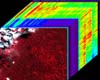 Stanford CA - Apr 07, 2004
Using a unique combination of ground-based and space-based tools, scientists have determined for the first time how drought conditions, and possibly carbon uptake, in the Amazon rainforest can be quantified over large forest areas from space. The results are published in the on-line early edition of the Proceedings of the National Academy of Sciences, April 5-9.
|
| ||||||||||
| The content herein, unless otherwise known to be public domain, are Copyright 1995-2016 - Space Media Network. All websites are published in Australia and are solely subject to Australian law and governed by Fair Use principals for news reporting and research purposes. AFP, UPI and IANS news wire stories are copyright Agence France-Presse, United Press International and Indo-Asia News Service. ESA news reports are copyright European Space Agency. All NASA sourced material is public domain. Additional copyrights may apply in whole or part to other bona fide parties. Advertising does not imply endorsement, agreement or approval of any opinions, statements or information provided by Space Media Network on any Web page published or hosted by Space Media Network. Privacy Statement All images and articles appearing on Space Media Network have been edited or digitally altered in some way. Any requests to remove copyright material will be acted upon in a timely and appropriate manner. Any attempt to extort money from Space Media Network will be ignored and reported to Australian Law Enforcement Agencies as a potential case of financial fraud involving the use of a telephonic carriage device or postal service. |