| . |  |
. |
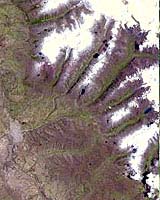
An Earth-monitoring instrument aboard NASA's Terra satellite is keeping a close eye on a potential glacial disaster-in-the-making in Peru's spectacular, snow-capped Cordillera Blanca (White Mountains), the highest range of the Peruvian Andes. Data from NASA's Advanced Spaceborne Thermal Emission and Reflection Radiometer (ASTER) is assisting Peruvian government officials and geologists in monitoring a glacier that feeds Lake Palcacocha, located high above the city of Huaraz, 270 kilometers (168 miles) north of Lima. An ominous crack has developed in the glacier. Should the large glacier chunk break off and fall into the lake, the ensuing flood could hurtle down the Cojup Valley into the Rio Santa Valley below, reaching Huaraz and its population of 60,000 in less than 15 minutes. "Remote sensing instruments like ASTER can serve a vital role in mountain hazard management and disaster mapping by providing rapid access to data, even in regions not easily accessible by humans," explained Dr. Michael Abrams, associate ASTER team leader at NASA's Jet Propulsion Laboratory, Pasadena, Calif. "ASTER's unique vantage point from space gives scientists another tool with which to see early signs of potential glacial flood-burst events and to monitor changes in glacial behavior over time. "In Huaraz, Peruvian authorities and scientists will incorporate ASTER data along with data from ground-based monitoring techniques to better assess current conditions and take steps necessary to reduce risks to human lives and property," Abrams said. Huaraz can be seen in the images' left-center, with Lake Palcacocha in the images' upper right corners at the head of a valley, below the snow and glacier cap. The left image was acquired on November 5, 2001; the right on April 8, 2003. Glacial flood-bursts, known by Peruvians as "aluviones," occur periodically when water is released abruptly from a previously ice-damned lake alongside, within or above a glacier. The release can be caused by various triggering events. These flood-bursts typically arrive with little or no warning, carrying liquid mud, large rock boulders and blocks of ice. The Rio Santa Valley is no stranger to such disasters. Since 1702, floods caused by glaciological conditions have repeatedly caused death and destruction in the region. One particularly devastating event in 1941 destroyed approximately one-third of Huaraz, killing an estimated 5,000 to 7,000 people. Since then, the Peruvian government has emphasized control of the water level in Lake Palcacocha and other lakes in the region that pose similar threats. The efforts appear to have worked; since 1972, no destructive floods resulting from the breakout of glacial lakes have occurred. Nevertheless, officials are still monitoring the current situation closely. ASTER's broad spectral coverage and high spectral resolution is ideally suited for monitoring dynamic conditions and changes in Earth's landscape over time, including glacial advances and retreats. Its 14 spectral bands measure from the visible to the thermal infrared wavelength region, and it can "see" at a resolution of 15 to 90 meters (about 50 to 300 feet). ASTER provides scientists in numerous disciplines critical information used for surface mapping and monitoring of dynamic conditions and changes over time.
It can also image the same area as frequently as every other day in response to urgent priorities. ASTER is one of five Earth-observing instruments launched December 18, 1999, on NASA's Terra satellite. Japan's Ministry of Economy, Trade and Industry built the instrument. A joint U.S./Japan science team is responsible for validation and calibration of the instrument and the data products. The Terra satellite is part of NASA's Earth Science Enterprise. Related Links More Comparison Images TERRA at NASA SpaceDaily Search SpaceDaily Subscribe To SpaceDaily Express  Guildford - Apr 03, 2003
The initial Earth observation images captured by AlSAT-1, the first DMC microsatellite in orbit, have been released. These images demonstrate the remarkable capability and outstanding performance of the new microsatellite, which produces a unique combination of extremely large image area (up to 600x600 km swath width) at a ground sampling distance of 32-metres in three spectral bands.
|
| ||||||||||
| The content herein, unless otherwise known to be public domain, are Copyright 1995-2016 - Space Media Network. All websites are published in Australia and are solely subject to Australian law and governed by Fair Use principals for news reporting and research purposes. AFP, UPI and IANS news wire stories are copyright Agence France-Presse, United Press International and Indo-Asia News Service. ESA news reports are copyright European Space Agency. All NASA sourced material is public domain. Additional copyrights may apply in whole or part to other bona fide parties. Advertising does not imply endorsement, agreement or approval of any opinions, statements or information provided by Space Media Network on any Web page published or hosted by Space Media Network. Privacy Statement All images and articles appearing on Space Media Network have been edited or digitally altered in some way. Any requests to remove copyright material will be acted upon in a timely and appropriate manner. Any attempt to extort money from Space Media Network will be ignored and reported to Australian Law Enforcement Agencies as a potential case of financial fraud involving the use of a telephonic carriage device or postal service. |