| . |  |
. |
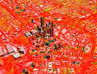
NASA has awarded funding for nine new investigations for technology development of innovative Earth Science remote-sensing instruments, under the Instrument Incubator Program (IIP), to support the mission to understand and protect our home planet.
The selected proposals focus on high-priority measurement areas of:
The technologies selected include hyperspectral grating spectrometer technologies for measuring coastal region features and key chemical constituents in the troposphere that contribute to pollution. Advanced grating spectrometer technologies will also be studied for measuring atmospheric temperature and moisture from geosynchronous orbit. Also selected are microwave radiometer and advanced radar technologies to measure sea-ice thickness, snow cover and rainfall, to support understanding cycling of Earth's fresh water, variation of its climate, and monitoring of volcanoes, earthquakes and hazardous weather from geosynchronous orbits. An innovative investigation will explore technologies to place a solar-occultation instrument at the L2 Lagrangian point, about 1,500,000 km on the dark side of the Earth, to perform continuous profiling of many trace gases in the Earth's atmosphere. Technologies to measure fine deformations of the Earth's crust, using interferometric synthetic aperture radars, and to measure minute changes in Earth's gravitation field will also be developed. The objective is better understanding of natural hazards such as earthquakes, volcanoes, flooding, sea level change and severe storms. The selected advanced technology projects will allow the next generation of orbiting environmental research satellites to observe Earth's atmosphere, oceans and continents in minutes and seconds compared to days and hours. The enhanced temporal coverage compliments the enhanced spatial resolution that has been the hallmark of NASA's Earth Science remote sensing technologies since the dawn of the space age.
The investigations selected by NASA's Office of Earth Science are:
Related Links SpaceDaily Search SpaceDaily Subscribe To SpaceDaily Express 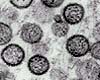 Baltimore - Dec 17, 2002
Researchers from the Johns Hopkins Bloomberg School of Public Health and other institutions report that satellite imagery could be used to determine areas at high-risk for exposure to Sin Nombre virus (SNV), a rodent-born disease that causes the often fatal hantaviral pulmonary syndrome (HPS) in humans.
|
| ||||||||||
| The content herein, unless otherwise known to be public domain, are Copyright 1995-2016 - Space Media Network. All websites are published in Australia and are solely subject to Australian law and governed by Fair Use principals for news reporting and research purposes. AFP, UPI and IANS news wire stories are copyright Agence France-Presse, United Press International and Indo-Asia News Service. ESA news reports are copyright European Space Agency. All NASA sourced material is public domain. Additional copyrights may apply in whole or part to other bona fide parties. Advertising does not imply endorsement, agreement or approval of any opinions, statements or information provided by Space Media Network on any Web page published or hosted by Space Media Network. Privacy Statement All images and articles appearing on Space Media Network have been edited or digitally altered in some way. Any requests to remove copyright material will be acted upon in a timely and appropriate manner. Any attempt to extort money from Space Media Network will be ignored and reported to Australian Law Enforcement Agencies as a potential case of financial fraud involving the use of a telephonic carriage device or postal service. |