| . |  |
. |
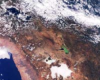
A joint programme established by the United Nations and the European Space Agency (ESA) to teach advanced remote-sensing technologies is paying off for Earth observation specialists in Chile and other Latin American countries. The UN/ESA Course Follow-up Programme, established in 1998, is being coordinated by the UN's Office for Outer Space Affairs (OOSA) in Vienna, and ESA's ESRIN facility in Frascati, Italy. Its aim is to provide national institutions with follow-on support for remote sensing applications in ongoing sustainable development activities. In 1999, the programme started to bring together government and university researchers from Bolivia, Argentina and Chile with ESA specialists for a series regional seminars and pilot projects for training in various Earth observation technologies. Much of the training centred on interferometric techniques for synthetic aperture radar, combining two radar images of the same spot of the Earth taken at different times from slightly different angles and analysing the phase differences. The programme finished in June, but for Carlos Pattillo, the project leader and director of Chile's Centre for the Study of Remote Sensing and Geographic Information Systems (CPR&SIG), in Santiago, the training provided by ESA Earth scientists will have a lasting regional impact: "The countries who participated in the programme now have in-house technology to use interferometry as a normal technique for other national projects. More importantly, a group of professionals in these countries has up-to-date knowledge to teach these technologies to others." In Chile the training allowed the Antarctic Institute of Chile (INACH) to start a facility for interferometry processing open to scientists in the region who are interested in ice and glacier studies. This takes advantage, Pattillo says, of an agreement signed between ESA and the German Aerospace Centre (DLR) for operations at Chile's Bernardo O'Higgins Antarctic Base. The base is a receiving station for data from ESA's ERS, the U.S. Landsat and Canada's Radarsat programmes, and supports German Antarctic research. "The INACH facility is getting our permanent support to teach scientists interested in using interferometry and to solve any technical problems that they may encounter," Pattillo said.
University programme goes commercial Without any computer hardware and software, private and corporate support was solicited to get the program off the ground in 1998. Since then, more than 30 theses have been completed on remote sensing and GIS subjects. Five of those were completed by students who were allowed to participate from other universities. The university programme also ran a series of technology- transfer projects to help private companies and governmental institutions implement the technologies being taught in the classrooms. These projects were financed by interested organization, and brought the university into closer contact with ESA, France's Aerospace Remote Sensing Development Group and CNES, the French space agency. "With their assistance and agreements of understanding and cooperation, we developed a variety of training courses and international seminars," Pattillo said. The academic programme, however, hit some organisational snags. Except for paying the salaries of two professionals, the university did not provide any operational funding for the remote-sensing projects; everything had to be financed by the pilot projects, including courses and theses. The university also decided to re-organise these types of programmes, handing over administrative responsibilities to one of the school's faculties. The programme, renamed the Remote Sensing and GIS Centre, was then hit with a 20 percent budget cut, hindering the capability of the Centre to compete with other enterprises. Pushed by these administrative problems, Pattillo and his faculty decided to form a private company and formally established CPR&SIG in January with a staff of seven full-time professionals.
The now-privatised Centre uses Earth observation imagery from a variety of sources:
Environmental applications for the Centre's services include: forest fire detection and evaluation; analysis of soil erosion after forest clear cutting; studies of water sediment and eutrophication, the process by which nutrients dissolve in water and artificially stimulate plant growth; and, environmental baseline studies for urban planning and civil infrastructure.
Recent Projects A three-year-long project has been the study of dunes over the coastal zone of central Chile. In this one, SPOT images was used to assess environmental changes, including the loss of vegetation and the reactivation of sand dunes, caused by industry and urban growth in fragile areas formed by old dunes plains. This project has been financed by Chile's National Science Fund with the cooperation of France's National Centre for Scientific Research and a research project with the University of Nantes. CPR&SIG is currently working on a follow-up program to use imagery from ESA's ERS and Envisat satellites to analyse the physical characteristics of the dunes environments. Other projects include the use of Landsat images for chlorophyll assessment in bodies of water, pollution of coastal zones by the iron industry in northern Chile, Radarsat images for evaluating the environmental condition of rangelands in southern Chile, and ERS interferometry for updating maps and generating digital elevation models.
What needs to be done "A lot of pilot projects have been done, but there are still no operational projects underway due mainly to the lack of a critical mass of trained professionals," Pattillo explained. Pattillo outlined his intent to focus international participation on carrying out one or two operational projects, and in forming permanent training facilities in each Latin American country. He said that the Latin American Remote Sensing Society (SELPER), a regional association of imagery specialists of which ESA is a special member, has been promoting actively the use of satellite remote sensing with assistance from ESA. Pattillo, who serves as SELPER's representative in Chile, noted that the association was formed in 1981 and currently has chapters in every Latin American country. "Through SELPER-Chile, we have encouraged Chilean professionals to use remote sensing and there are nearly 90 SELPER associates here alone that could benefit from a permanent training facility," Pattillo said. "Once again, ESA's help will be necessary to keep focusing the activities in this direction. Our company will continue its training activities, but we think that this effort should be undertaken in a bigger scale, and that means at a national level with formal resources from the government." Related Links CPR&SIG SELPER-Chile UN OOSA Earthnet Envisat Results ERS GMES International Charter on Space & Major Disasters CEOS SpaceDaily Search SpaceDaily Subscribe To SpaceDaily Express  Pasadena - Aug 19, 2002
A recently concluded NASA aerial field experiment, high above our nation's heartland, may lead to a clearer understanding of soil moisture-- a key variable in Earth's global water cycle that profoundly influences seasonal weather patterns and agriculture.
|
| ||||||||||
| The content herein, unless otherwise known to be public domain, are Copyright 1995-2016 - Space Media Network. All websites are published in Australia and are solely subject to Australian law and governed by Fair Use principals for news reporting and research purposes. AFP, UPI and IANS news wire stories are copyright Agence France-Presse, United Press International and Indo-Asia News Service. ESA news reports are copyright European Space Agency. All NASA sourced material is public domain. Additional copyrights may apply in whole or part to other bona fide parties. Advertising does not imply endorsement, agreement or approval of any opinions, statements or information provided by Space Media Network on any Web page published or hosted by Space Media Network. Privacy Statement All images and articles appearing on Space Media Network have been edited or digitally altered in some way. Any requests to remove copyright material will be acted upon in a timely and appropriate manner. Any attempt to extort money from Space Media Network will be ignored and reported to Australian Law Enforcement Agencies as a potential case of financial fraud involving the use of a telephonic carriage device or postal service. |