| . |  |
. |
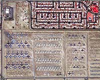
Like piecing a jigsaw puzzle together, Digital Images Made Easy (DIMETM), a new software product developed and marketed by Positive Systems, Inc., of Whitefish, Mont., can integrate a series of aerial or satellite snapshots into a single panoramic image, providing a cost-effective and time-saving new tool for urban and rural resource managers and planners. Aerial and satellite imagery is in common use today by engineers, planners, and managers as an important source of information for land use decision-making. However, this technology must be processed and interpreted by trained technicians, making it costly and labor-intensive. DIME software significantly increases the usefulness of satellite and aerial information by resolving three major problems associated with digital imagery: accurately combining series of images into one large panoramic picture; reconciling color differences between like features in serial images; and ensuring accurate location of features once the flat images are "pinned" to the round surface of the earth. The Montana State University TechLink Center, a regional technology transfer office located in Bozeman, helped Positive Systems develop its prototype software product by partnering the company with NASA for joint research and development. Initial development took place in 1998 and once the prototype software was developed, the company worked with TechLink and NASA to put it through a rigorous series of tests. Positive Systems was later awarded a three-year, multi-million dollar contract with NASA that ultimately led to the preparation of more than 20,000 images with DIME. Positive Systems continues to refine and develop the software product that is now marketed worldwide. Dale Johnson, a Positive Systems Vice President, states that the relationship with NASA was invaluable. "As a result of interacting with NASA, our understanding of the market and the valuable research that could be conducted as a result of preparing imagery with DIME was greatly enhanced." One of DIME's most unique features is the ability to collect and assemble a series of digital images of large geographic areas into single panoramic images, known in the geographic information system (GIS) industry as a "mosaick." The mosaicked images are useful backdrops to GIS maps, which typically consist of line drawings (referred to as "vectors"), by allowing the user to view a multi-dimensional map that provides significantly more geographic information. The DIME software resolves other problems with digital imagery, too. Variations in colors of like features occur naturally because of solar radiation and differences in the angle between the sun and the aircraft, which constantly changes as the aircraft flies over the target area collecting photographs. These variations in color make misinterpretation of features possible. DIME corrects for the changing sun angle and balances the colors of earth features when multiple images are combined into a single composite image. This process is known as "color balancing" and makes identification of features more accurate. Another common problem associated with digital imagery acquired above the earth is that the images are flat, but their subject, the earth, is round. This can lead to inaccuracies in locating features. DIME can establish precise longitudinal and latitudinal locations of geographic features and essentially "pins" the aerial images to the ground so that the features can be accurately located, mapped, and identified. DIME is a Microsoft Windows application and is easy to install on standard office computers. Version 2.1, released in February of this year, is appropriate for small format film and digital camera users. Version 3.0, scheduled for release late in the fourth quarter of this year, will include a multitude of enhancements, improved color balancing features among them. TechLink is located at Montana State University in Bozeman and funded by NASA and the Department of Defense to link companies in Montana and the surrounding region with federal laboratories for licensing, joint research, transfer, and commercialization of new technology. Its purpose is to contribute to the success of both technology-based companies and key resource-based industries in the state and region. Related Links MSU TechLink Center SpaceDaily Search SpaceDaily Subscribe To SpaceDaily Express  Bozeman - Sept. 20, 2001
Montana's high tech farmers are looking at their fields with new "eye in the sky" technology this summer, thanks to NASA and the MSU TechLink Center. In its first comprehensive remote sensing evaluation project, the Precision Agriculture Research Association (PARA) is comparing different types of imagery as a real-time decision aid to help determine when and where to apply fertilizers, pesticides, and nutrients to their crops.
|
| ||||||||||
| The content herein, unless otherwise known to be public domain, are Copyright 1995-2016 - Space Media Network. All websites are published in Australia and are solely subject to Australian law and governed by Fair Use principals for news reporting and research purposes. AFP, UPI and IANS news wire stories are copyright Agence France-Presse, United Press International and Indo-Asia News Service. ESA news reports are copyright European Space Agency. All NASA sourced material is public domain. Additional copyrights may apply in whole or part to other bona fide parties. Advertising does not imply endorsement, agreement or approval of any opinions, statements or information provided by Space Media Network on any Web page published or hosted by Space Media Network. Privacy Statement All images and articles appearing on Space Media Network have been edited or digitally altered in some way. Any requests to remove copyright material will be acted upon in a timely and appropriate manner. Any attempt to extort money from Space Media Network will be ignored and reported to Australian Law Enforcement Agencies as a potential case of financial fraud involving the use of a telephonic carriage device or postal service. |