| . |  |
. |
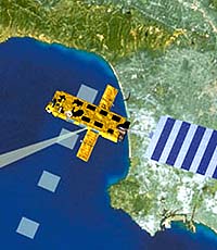
A major new health check on the Earth got under way on 1 March 2002, when the European Space Agency's Envisat satellite was launched by an Ariane 5 rocket from Europe's spaceport in French Guiana. It is the largest and most sophisticated Earth observation satellite ever built. Following the launch and deployment of the solar panel and antennas, the ten instruments on board the satellite were turned on and verified one by one: all are operating nominally. The satellite is performing well and providing measurements of the atmosphere, ocean, land and ice, providing a new, enhanced perspective on questions related to global environmental monitoring and climate change. Envisat will reveal new data and build further on the information gathered over the past ten years by ESA's ERS-1 and ERS-2 satellites, which has given important insights into the impact of human activity on the environment and put issues such as ozone depletion and pollution on the agenda of decision-makers and the media. The first data available from the satellite were acquired via the Kiruna station in Sweden and processed at the ESA/ESRIN establishment and processing and archiving centres throughout Europe. The first images from the ASAR radar and the MERIS instrument are of exceptionally high quality, as demonstrated by data acquisitions covering areas of Antarctica and West Africa. Envisat was launched just in time to observe the break-up of Larsen B in Antarctica. The collapse of this 3250 km2 ice shelf depicted in the ASAR image is the latest dramatic event in a region of Antarctica that has experienced unprecedented warming in the last 50 years. Over the last month, the 200m thick ice shelf has collapsed into small icebergs and fragments moving as a plume of medium-high radar reflectivity from the area south of Seal Nunataks towards the Weddell Sea. This is the largest single event in a series of retreats by ice shelves along the Antarctic Peninsula. These retreats are attributed to accelerating climate warming in the region. The average rate of warming is approximately 0.5 degrees Celsius per decade and the trend has been present since at least the late 1940s. The data acquired by Envisat and the ERS data since 1992 show the retreat of the Larsen B and other ice shelves, an important indicator of climate change in polar regions. These observations are of significance not only to our understanding of ice dynamics and ice/climate interactions, but also to that of global ocean circulation, as ice shelves play an important role in the production of bottom water. Among the ten instruments on board Envisat, MERIS (Medium-Resolution Imaging Spectrometer) detected phytoplankton concentration and measured chlorophyll concentration over the West African region during the first few days of its operations. Another important capability of the instrument is the provision of overviews of dynamic upwelling areas and their primary production. This information helps in the management of fish stocks as the main fishing grounds are in upwelling areas. Where the upwelling process collapses, as has happened along the Peruvian coast during El Nino events, the whole regional fishing industry also collapses. Any climate change has an impact on the intensity and geographical position of upwelling areas, with major repercussions on the local economy and the quality of life in such regions. Another feature of MERIS is its delivery of information on primary production of the global ocean for a better understanding of the carbon cycle. The observing capabilities of the MERIS spectrometer, together with the synergistic use of various other instruments on board Envisat, will provide very accurate measurements of sea surface temperature and help understanding of interactions between wind, temperature and phytoplankton growth. Through Envisat, Europe has acquired a powerful new means of monitoring key issues related to global environment and climate change. The satellite will enhance monitoring capabilities, provide information for warning and mitigation of climate change, and make precise measurements of the Earth to manage the implementation of major international environmental conventions such as the Kyoto Protocol, under which Europe has recently undertaken to reduce greenhouse gas emissions by 8% from 1990 levels by 2008-2012. Related Links Envisat Mission Home SpaceDaily Search SpaceDaily Subscribe To SpaceDaily Express 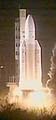 Kourou (AFP) Feb 28, 2002
Europe's powerful Ariane-5 rocket lifted-off here late Thursday and launched Europe's biggest ever satellite into orbit. The 8.2 tonne satellite, Envisat, was released into orbit 27 minutes after the Ariane-5 rocket lifted off from the space centre at Kourou in French Guiana at 10:07 pm (0107 GMT Friday). The 2.4-billion-euro (2.1-billion-dollar) satellite, baptised Envisat (for "environmental satellite), is the heaviest and most complex ever launched by the ESA and will comprehensively monitor the Earth's environmental changes.
|
| ||||||||||
| The content herein, unless otherwise known to be public domain, are Copyright 1995-2016 - Space Media Network. All websites are published in Australia and are solely subject to Australian law and governed by Fair Use principals for news reporting and research purposes. AFP, UPI and IANS news wire stories are copyright Agence France-Presse, United Press International and Indo-Asia News Service. ESA news reports are copyright European Space Agency. All NASA sourced material is public domain. Additional copyrights may apply in whole or part to other bona fide parties. Advertising does not imply endorsement, agreement or approval of any opinions, statements or information provided by Space Media Network on any Web page published or hosted by Space Media Network. Privacy Statement All images and articles appearing on Space Media Network have been edited or digitally altered in some way. Any requests to remove copyright material will be acted upon in a timely and appropriate manner. Any attempt to extort money from Space Media Network will be ignored and reported to Australian Law Enforcement Agencies as a potential case of financial fraud involving the use of a telephonic carriage device or postal service. |