| . |  |
. |
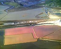
NASA technology is helping state and federal governments reclaim 15,100 acres of salt evaporation ponds in South San Francisco Bay, during one of the nation's largest restoration projects. A small group of NASA scientists and technicians is studying salt evaporation ponds by using sensors on satellites and airplanes in addition to surface sampling, to learn how restoring the ponds to nearly their natural state may affect local ecology. The U.S. Fish and Wildlife Service and the California Department of Fish and Game recently bought many salt ponds from the Cargill Salt Company for $100 million. Scientists think the project will continue for more than 20 years. "It is the largest tidal wetland restoration project in the western United States," said Marge Kolar of the U.S. Fish and Wildlife Service, Fremont, Calif. "We are using sensors on satellites and aircraft, together with on-site sampling, to evaluate water quality of coastal wetland environments in the southern San Francisco Bay," said L. Jean Palmer-Moloney, a visiting geography professor from the State University of New York, Oneonta, who is leading the monitoring effort at NASA Ames Research Center, located in California's Silicon Valley. Her team includes Jim Brass, Dana Rogoff and Brad Dalton, all of NASA Ames. For more than a century, people used the salt ponds and the abundant California sunshine to evaporate water and collect salt. This process changed the natural habitat of local plants and animals. The U.S. government, the state of California and other organizations now are working to restore the salt ponds to as close to the original, natural habitat as is practical. Work includes reducing salinity, reconnecting many of the ponds to the bay and looking for changes in the local environment. "We are in a position to help determine the current state of the ponds," Palmer-Moloney said. "As the transition from salt ponds to tidal marsh habitat progresses over the years, we will be able to monitor ecosystem changes with satellite- and aircraft-acquired data to supplement field data collection," Palmer-Moloney added. "We are taking samples from the ponds to determine what microbes live there as well as what the salt content is," said Rogoff, a laboratory technician working on the project. "We also will start using satellite imaging to monitor the ponds' microbial life," she added. Dirt levees separate the ponds from the bay. Before workers open levees to return the ponds to the natural ecosystem, experts must look at the effects of changing the salinity and habitat. The California Regional Water Quality Board in Oakland is working with the U.S. Fish and Wildlife Service and the California Department of Fish and Game to determine 'safe' salinity discharge levels, according to Palmer-Moloney. "When trying to understand the current state of the ecosystem in the south bay, the traditional method of getting information is from point sampling," said Palmer-Moloney. Collecting a water sample from a pond is one example of point sampling, she added. "In the field, a sample might show water pH, water temperature, salinity. In the lab, this same sample would provide information on the microbes that live in the water," Palmer-Moloney explained. "If you fly a plane over the salt ponds along the bay, you'll see they are different colors," Rogoff said. "These colors are often due to the microbes that live there, and we need to monitor them to make sure that we keep everything in balance as the team opens more of the ponds to the bay," Rogoff added. Remote sensing from satellites and aircraft allows scientists to quickly deduce surface conditions over a wide area, the equal of hundreds of hours of point-sampling on the ground, according to Palmer-Moloney. Remote sensing is the use of sensors by satellites and aircraft to take images of parts of the Earth's surface in many wavelengths, some beyond the reach of the human eye. "We are interested in helping and facilitating decision making in the restoration process, which is converting salt ponds to tidal marsh habitat," Palmer-Moloney said. "In a densely populated urban area such as the San Francisco Bay area, green space and open space are precious commodities, and right now, the urban build-up all the way to the edge of the bay has been held in check for about a hundred years by the industrial use of the coastal wetlands as salt ponds." Over the years, human activities have changed the ecosystem of the southern San Francisco Bay. Some native plants and animals cannot tolerate the higher salt content of the ponds. Yet other animals such as the snowy plover bird thrive in the higher salt environments. "What's going to happen is that some of the ponds will be restored as closely as possible to the original, natural condition of more than a century ago," Palmer-Moloney said. "However, the project will maintain some of the salt ponds with higher salinity in order to provide niches for animals and plants that prefer a higher salinity habitat." Many salt evaporation ponds are located next to NASA property. "The ecosystem doesn't recognize boundaries that humans draw on maps," Palmer-Moloney said. "There are interconnections between NASA land and the restoration area. There is an opportunity for NASA to contribute to the bay restoration project. NASA has satellites and aircraft with remote-sensing instruments already in place, and this is a wonderful opportunity to use them." According to NASA scientists, the use of remote sensing to study coastal wetland environments is fairly new, and the work now underway to monitor the salt ponds in South San Francisco Bay may well serve as a prototype for cooperative research by other state and federal agencies. "Hopefully, we can take some of what we're learning in southern San Francisco Bay and use it in other wetland areas in this country and abroad," said Palmer-Moloney. "In July, I'll be going to Belize, located just south of Mexico's Yucatan Peninsula. In Belize, I'll be studying a place called Chetumal Bay to examine how to apply technology we are using in the southern San Francisco Bay in Chetumal to characterize and document change in tropical salt marsh environments." Palmer-Moloney plans to work with Belize's Ministry of Natural Resources' Coastal Zone Management organization. Some NASA scientific instruments scientists are using in the south San Francisco Bay salt pond recovery effort include the Advanced Spaceborne Thermal Emission and Reflection Radiometer (ASTER) on the Terra satellite; the Moderate Resolution Imaging Spectroradiometer (MODIS) instrument on the Terra and Aqua satellites; and the thematic mapper on the Landsat 5 satellite. Related Links The salt ponds project SpaceDaily Search SpaceDaily Subscribe To SpaceDaily Express  Atlanta - Jul 03, 2003
Researchers have isolated a novel bacterium that flourishes as it destroys harmful chlorinated compounds in polluted environments, leaving behind environmentally benign end products.
|
| ||||||||||
| The content herein, unless otherwise known to be public domain, are Copyright 1995-2016 - Space Media Network. All websites are published in Australia and are solely subject to Australian law and governed by Fair Use principals for news reporting and research purposes. AFP, UPI and IANS news wire stories are copyright Agence France-Presse, United Press International and Indo-Asia News Service. ESA news reports are copyright European Space Agency. All NASA sourced material is public domain. Additional copyrights may apply in whole or part to other bona fide parties. Advertising does not imply endorsement, agreement or approval of any opinions, statements or information provided by Space Media Network on any Web page published or hosted by Space Media Network. Privacy Statement All images and articles appearing on Space Media Network have been edited or digitally altered in some way. Any requests to remove copyright material will be acted upon in a timely and appropriate manner. Any attempt to extort money from Space Media Network will be ignored and reported to Australian Law Enforcement Agencies as a potential case of financial fraud involving the use of a telephonic carriage device or postal service. |