| . |  |
. |
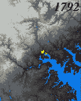
for NASA Science News Huntsville - Oct 15, 2002 While space technology was undergoing its spectacular birth during the 1950s and '60s, and visionaries were predicting the spread of human colonies into space, another kind of human colony was spreading rapidly--right here on Earth! It was the dawn of the modern suburb, a time of post-war prosperity when housing developments popped up across the landscape like mushrooms after a rain. A half-century later, we now understand that many environmental problems accompany the outward spread of cities: fragmenting and destroying wildlife habitat, for example, and discharging polluted runoff water into streams and lakes. The emerging space technology of the 1950s has grown along with our cities. As you read this today, dozens of high-tech satellites are circling our planet, gathering terabytes of scientific data about the environment. These data provide a unique "big picture" view of the effects of urban sprawl. Unfortunately, many city planners still don't have access to that big picture. "Currently there's no good end-to-end system for getting useful satellite data on the impacts of urban sprawl into the hands of local decision makers," says Chet Arnold, associate director of the Center for Land-use Education and Research at the University of Connecticut (UConn). But he and his colleagues at UConn are working with NASA to change that. They've started a project called NAUTILUS to provide city planners satellite data quickly and in a form that non-scientists can understand. "NAUTILUS is one of seven Regional Earth Science Application Centers (or "RESACs") around the country funded by NASA," says Rodney McKellip, who manages the RESAC program from the Stennis Space Center in Mississippi. Why NASA? The Earth Science Enterprise of NASA is responsible for many of those satellites circling the earth, and they are used to fulfill NASA's mission to understand and protect our home planet. "RESAC was started in 1998," continues McKellip, "as a way to get vital Earth science information into the hands of local and regional decision makers." Currently, the NAUTILUS team is developing their remote-sensing tools in four test regions in Connecticut, Massachusetts, Maine, and New Jersey. The local public officials in these regions are making their information needs known, and the scientists are learning to format the satellite data in ways that meet those needs: color-coded maps, for example, or time-lapse animations. Because humans are so visually oriented, such graphics can communicate lots of complex information in a quick, intuitive way. Simply watching a 30-year animation that shows your city rapidly engulfing the landscape can be an eye-opening experience. "We all sat there a little stunned," says Christine Nelson, recalling the first time she and her fellow city officials were shown animations of historical city growth. Nelson, who is the director of the land use department for the Town of Old Saybrook, Connecticut, participated in a related UConn program called Nonpoint Education for Municipal Officials (NEMO). The satellite record gives a compelling view of the past, but what about the future? After all, it's the future consequences of land use that city planners must contemplate. One tool that the NAUTILUS researchers are using is like a computerized "crystal ball." It's a software package (based on a standard map-viewing program called ArcView) that lets city planners envision a hypothetical future of their city, assuming that it grew according to current zoning patterns. They can view simple maps, color-coded for environmental impacts, or they can choose to "fly through" a photorealistic 3D map of their future city to get a more visceral sense of things to come. More importantly, it lets them make changes and view the likely outcome of different growth scenarios. More-sophisticated techniques can wring all kinds of useful numbers from satellite data: estimates of water-quality degradation due to development, for example. Hard numbers like these are crucial for making and justifying the tough decisions public officials face. In the cities involved with the NEMO and NAUTILUS pilot projects, these accessible forms of satellite data have already had an impact on decision making. Nelson offers this anecdote from her own Town of Old Saybrook: "Using these new satellite-based tools, the planning commission recently realized that huge tracts of unfragmented forest will be interlaced with paved roads as residential development sprawls into the relatively undeveloped northwest quarter of town." Such "forest fragmentation" can cause problems. "Forest fragmentation occurs when large, continuous forests are divided into smaller blocks, either by roads, clearing for agriculture, urbanization, or other human development," explains Arnold. "Increased fragmentation due to urban development poses a threat to biodiversity primarily in animal populations, as their habitats are chopped up (fragmented) into smaller and smaller pieces." To avoid these problems near the Town of Old Saybrook, "the planning commission (inspired by the satellite data) is spearheading modifications to the comprehensive plan of zoning regulations," notes Nelson. Bringing together the information for these maps also means working out a lot of technical nitty-gritty. There are dozens of Earth-observing satellites: Terra, Aqua, Landsat, SPOT and IKONOS, for example. Each carries its own suite of scientific instruments. Which data should the NAUTILUS system use? And how can the 30-year satellite record--taken from a series of satellites with different properties--be integrated into a consistent record of changes in the landscape during that time? The NAUTILUS program is working these details out so that city planners don't have to. If the project is successful, other cities will soon join Old Saybrook in using satellites to better understand the environmental impact of humanity's expanding "colonies" here on Earth. Related Links SpaceDaily Search SpaceDaily Subscribe To SpaceDaily Express  Tucson - Aug 26, 2002
From an ecological perspective, cities are stressed out. Urban trees struggle to stay alive as they contend with concrete-encrusted roots and the pounding of automobile traffic. Normal water flows are redirected under buildings and roads into concrete channels. Habitats are severely fragmented and energy and nutrient cycles are disrupted.
|
| ||||||||||
| The content herein, unless otherwise known to be public domain, are Copyright 1995-2016 - Space Media Network. All websites are published in Australia and are solely subject to Australian law and governed by Fair Use principals for news reporting and research purposes. AFP, UPI and IANS news wire stories are copyright Agence France-Presse, United Press International and Indo-Asia News Service. ESA news reports are copyright European Space Agency. All NASA sourced material is public domain. Additional copyrights may apply in whole or part to other bona fide parties. Advertising does not imply endorsement, agreement or approval of any opinions, statements or information provided by Space Media Network on any Web page published or hosted by Space Media Network. Privacy Statement All images and articles appearing on Space Media Network have been edited or digitally altered in some way. Any requests to remove copyright material will be acted upon in a timely and appropriate manner. Any attempt to extort money from Space Media Network will be ignored and reported to Australian Law Enforcement Agencies as a potential case of financial fraud involving the use of a telephonic carriage device or postal service. |