| . |  |
. |
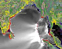
DigitalGlobe has announced that ImageCat is using DigitalGlobe's QuickBird satellite imagery to assess damage resulting from the massive Indian Ocean tsunami that was triggered by an earthquake on Dec. 26, killing more than 226,000 people. On Jan. 7, ImageCat and the Multidisciplinary Center for Earthquake Engineering Research (MCEER) traveled to Phuket, Thailand with engineers from Japan's Chiba University and Bangkok's Asian Institute of Technology to document and analyze the tsunami damage. In Thailand, more than 5,300 people were killed, important tourist destinations were devastated, and the shrimp industry suffered US$500 million in damage. The team deployed ImageCat's custom-built Visualizing Impacts of Earthquakes with Satellites (VIEWS), a portable notebook-based reconnaissance system that links high-resolution QuickBird imagery, digital photographs and digital video footage to a real-time GPS feed. The team used 60-centimeter QuickBird imagery collected over Patong Beach in Phuket on Jan. 2, 2005, and for comparison purposes, imagery collected in March 2002. VIEWS is operated with a digital video recorder and digital camera from either a moving vehicle or on-foot, and produces a permanent visual record of damage. "QuickBird imagery helped identify key landmarks so that we could orient ourselves and navigate the area," said ImageCat's Shubharoop Ghosh, transportation systems analyst, who joined Japan's Professor Fumio Yamazaki and Thailand's Dr. Pennung Warnitchai on the expedition. "By essentially freezing events in time, VIEWS and the imagery helped us reconstruct the site after we returned to our home offices," Ghosh added. A field report detailing ImageCat's findings is located at: https://mceer.buffalo.edu/research/tsunami/page1.asp. ImageCat has used QuickBird imagery and the MCEER-funded VIEWS extensively for evaluating disasters, including the Oct. 2004 earthquake in Niigata, Japan; Florida's Aug. 2004 Hurricane Charley and Sept. 2004 Hurricane Ivan; and the Dec. 2003 Bam, Iran earthquake. Related Links ImageCat DigitalGlobe SpaceDaily Search SpaceDaily Subscribe To SpaceDaily Express  Bedminster NJ (SPX) Feb 04, 2005
Loral Skynet has announced that it has been selected to provide satellite communications services to the British Foreign and Commonwealth Office (FCO), through an agreement with Global Crossing, that will support the FCO's recovery efforts related to the tsunami disaster.
|
| ||||||||||
| The content herein, unless otherwise known to be public domain, are Copyright 1995-2016 - Space Media Network. All websites are published in Australia and are solely subject to Australian law and governed by Fair Use principals for news reporting and research purposes. AFP, UPI and IANS news wire stories are copyright Agence France-Presse, United Press International and Indo-Asia News Service. ESA news reports are copyright European Space Agency. All NASA sourced material is public domain. Additional copyrights may apply in whole or part to other bona fide parties. Advertising does not imply endorsement, agreement or approval of any opinions, statements or information provided by Space Media Network on any Web page published or hosted by Space Media Network. Privacy Statement All images and articles appearing on Space Media Network have been edited or digitally altered in some way. Any requests to remove copyright material will be acted upon in a timely and appropriate manner. Any attempt to extort money from Space Media Network will be ignored and reported to Australian Law Enforcement Agencies as a potential case of financial fraud involving the use of a telephonic carriage device or postal service. |