|
Free Newsletters - Space News - Defense Alert - Environment Report - Energy Monitor |
| . |  |
. |
|
|
Look At Past Sea-Level Rise Points To Troubling Future
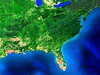
New research presented at this week's annual meeting of the Geological Society of America shows that rising sea levels of as little as a half-meter per century have been sufficient to dramatically change the shoreline of the U.S. Gulf Coast within the past 10,000 years. The findings are significant because half-meter increases are within the moderate range of predictions for the Gulf Coast during this century. "About 5,000 years ago, when sea level was rising approximately 50 centimeters per century, the upper part of Corpus Christi Bay increased by about one third over the span of about 200 years," said John Anderson, the W. Maurice Ewing Chair in Oceanography and professor of earth science at Rice University in Houston. "Even without factoring in any effects from global warming, that's only about 20 percent slower than the projected sea level increases along the Texas and Louisiana coasts this century." Scientists know from oceanographic records that sea level has been rising worldwide for at least 10,000 years. The exact cause is unknown, but the rates of rise for specific eras have been well documented from marine sedimentary records worldwide. Scientists know, for example, that rates of sea level rise have gradually fallen from more than 100 centimeters per century 10,000 years ago to about 20 centimeters per century today - a rate that's been confirmed using global tide gauge records from the past 100 years. But the trend toward slowing rates of sea level rise is expected to reverse this century, as global warming pushes rates back up. According to estimates by the International Panel for Climate Change, rising ocean temperatures this century will add about 30 centimeters to sea level, and glacial runoff from Antarctica - the least understood of all the phenomena involved - could add another 40 centimeters. Thus, the worst-case scenario could translate into a 90-centimeter boost in sea level by 2100- a rate of increase that global coastlines haven't experienced in about 8,000 years. Estimating the effects of rising seas on a particular coastline requires more than an accurate assessment of sea level rise, said Anderson. Local geography and geology also play a role. For instance, the coastal plains of southeast Texas and Louisiana are a vast sedimentary plain that is sinking at the rate of about 20 centimeters per century. Moreover, there are other geological forces at work that can be impacted or even overwhelmed by rising seas. "On geologic time scales, barrier islands like Texas' Galveston and Padre islands retreat toward land," said Anderson. "The Galveston shoreline, for example, is moving about 1.5 meters inland every year. But the same forces that are slowly eroding the beaches on the windward side of the island deposit that sand on the leeward side, so the island itself remains a stable barrier, even though it marches slowly toward shore." Anderson's research has found that rising seas can overwhelm fragile coastal structures like barrier islands and river delta headlands, the vast wetlands that are deposited by rivers when they empty into the sea. He began studying the geography of the U.S. Gulf Coast about 15 years ago. Four of his students - Alex Simms, Kristy Milliken, Jessie Maddox and Patrick Taha - are presenting new research Nov. 7-10 at the GSA's annual meeting in Denver. Much of the new research was done in collaboration with one of Anderson's former students, University of Alabama Professor Tony Rodriguez. The findings are drawn from analysis of seafloor cores and other experimental data collected by Anderson's group, which has used ships and barges to drill cores and take underwater soundings from the southern shores of Texas to Alabama's Mobile Bay. Analyses have begun to yield a catalogue of reactions that Gulf coastal features undergo in response to specific rates of sea-level rise. "We know that Sabine bank, a seafloor formation about 20 miles offshore along the Texas-Louisiana border, was a barrier island until just a few thousand years ago," Anderson said. "We know that it was drowned in place, because we have drilled core samples there. We still don't know what rate of sea-level rise it took to drown the island, but we're studying that." Rising seas can also overwhelm tidal wetlands, like those at the head of the Trinity River in upper Galveston Bay or the head of the Nueces River in upper Corpus Christi Bay. Anderson's group also is finding evidence that a catastrophic collapse of one coastal structure - like a barrier island - can result in stress or even in collapse of interconnected structures like tidal wetlands. "Even with past examples to guide us, devising an accurate model for local shoreline change will be difficult because there is a complex interplay between global events - like what's happening in Antarctica - and local geologic, oceanic, and atmospheric phenomena," said Anderson. "There are many more variables that go into this than I would ever have believed when I started studying the Gulf Coast in the 1980s." Related Links Rice University SpaceDaily Search SpaceDaily Subscribe To SpaceDaily Express  Greenbelt MD (SPX) Nov 05, 2004
Recently scientists from NASA and Open University in the United Kingdom set out to study how acid rain affects the methane gas that comes from wetlands in the U.S., England and Sweden.
|
| |||||||||||
| The content herein, unless otherwise known to be public domain, are Copyright 1995-2016 - Space Media Network. All websites are published in Australia and are solely subject to Australian law and governed by Fair Use principals for news reporting and research purposes. AFP, UPI and IANS news wire stories are copyright Agence France-Presse, United Press International and Indo-Asia News Service. ESA news reports are copyright European Space Agency. All NASA sourced material is public domain. Additional copyrights may apply in whole or part to other bona fide parties. Advertising does not imply endorsement, agreement or approval of any opinions, statements or information provided by Space Media Network on any Web page published or hosted by Space Media Network. Privacy Statement All images and articles appearing on Space Media Network have been edited or digitally altered in some way. Any requests to remove copyright material will be acted upon in a timely and appropriate manner. Any attempt to extort money from Space Media Network will be ignored and reported to Australian Law Enforcement Agencies as a potential case of financial fraud involving the use of a telephonic carriage device or postal service. |