|
|
| . |  |
. |
|
|
by Staff Writers Paris (AFP) Nov 14, 2013
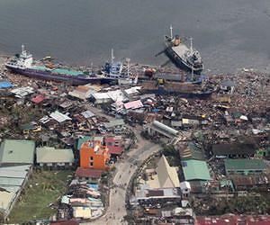
The United Nations has activated a constellation of satellites to help relief operations in the typhoon-ravaged Philippines, an official said on Thursday. Catherine Proy of France's National Centre for Space Studies (CNES) said the first discussions to activate the so-called International Charter on Space and Major Disasters took place on November 7, the day before Typhoon Haiyan struck. Under the Charter, 15 space agencies or national organisations agree to pool 25 ground-imaging satellites to help relief efforts hampered by a natural catastrophe, such as a storm, earthquake or tsunami. Their data can identify roads, bridges or railway lines that are passable or structures that are damaged or intact. "The charter was activated by the United Nations and its Office for the Coordination of Humanitarian Affairs," said Proy, whose organisation is part of the Charter group. "It was activated almost preventively. The first discussions took place on the Thursday, the day before the typhoon crossed the Philippines," Proy said in an interview with AFP. "The satellites were re-tasked on the Friday, the day when the cyclone hit." The UN is an "authorised user" of the Charter, giving it the right to invoke it. Once activated, space technicians under a rotating arrangement determine which satellites are available and best suited for the job, and then send a programme request to the operator for images. Satellites take the pictures as they fly over a zone, giving this mission a priority over other jobs. The data are usually available within 24 hours and are provided for free. The maps are put together by UNOSAT, a Geneva-based UN institute that specialises in satellite applications, which then disseminates it to aid agencies that request them. "Around 10 satellites have been requested, particularly optical satellites," said Proy. The first job was to identified undamaged buildings, especially in Tacloban, that could be used by relief organisations, she said. "We have now moved more towards Cebu and Bogo but there are also requests to cover areas that are much, much farther west, on other islands," said Proy, "It's very complicated for everyone," she said. "The biggest problem is that there is a huge area of destruction. To cover it, we need high-resolution images, but these have a limited scale of 20 kilometres by 20 kilometres (12 miles by 12 miles). "So right now we are only partially mapping the affected areas. We are also encountering problems with cloud cover, as it is the middle of the cyclone season."
Related Links Earth Observation News - Suppiliers, Technology and Application
|
|
| The content herein, unless otherwise known to be public domain, are Copyright 1995-2014 - Space Media Network. AFP, UPI and IANS news wire stories are copyright Agence France-Presse, United Press International and Indo-Asia News Service. ESA Portal Reports are copyright European Space Agency. All NASA sourced material is public domain. Additional copyrights may apply in whole or part to other bona fide parties. Advertising does not imply endorsement,agreement or approval of any opinions, statements or information provided by Space Media Network on any Web page published or hosted by Space Media Network. Privacy Statement |
 del.icio.us
 Digg
Digg Reddit
 Google