|
|
| . |  |
. |
|
|
by Staff Writers Philadelphia PA (SPX) Feb 18, 2013
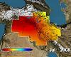
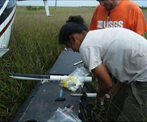
The spring 2011 flood on the Mississippi was among the largest floods ever, the river swelling over its banks and wreaking destruction in the surrounding areas. But a University of Pennsylvania-led study also shows that the floods reaped environmental benefits - transporting and laying down new sediment in portions of the Delta - that may help maintain the area's wetlands. The study, led by Ph.D. student Nicole Khan of the Department of Earth and Environmental Science, is the first to quantify the amount of sediment transported to wetlands by a flood on the Mississippi. The results shed light on how floods impact wetlands, and how these effects might be harnessed to purposefully rebuild Louisiana's wetlands, which are sinking from compaction and growing smaller as sea level rises. Additional Penn authors in the Department of Earth and Environmental Science include Benjamin Horton, an associate professor and Khan's advisor; Douglas Jerolmack, an assistant professor and Federico Falcini, formerly a postdoctoral researcher in Jerolmack's lab and now a researcher at the Consiglio Nazionale delle Ricerche in Rome. The Penn geologists partnered on the research with Karen McKee of the U.S. Geological Survey, Mihaela Enache of the Academy of Natural Sciences of Drexel University and Christopher Vane of the British Geological Survey. A study by many of the same scientists, published in Nature Geoscience last year, found that the 2011 Mississippi River floods deposited more sediment in the Atchafalaya River Basin, where the waters moved slowly over a broad area, than in the Mississippi River Basin, where levees and control structures funneled the floodwaters into a jet stream that shot water and sediment out into the Gulf of Mexico. The current study, published in Geology, focuses specifically on the questions of how much sediment was laid down in the river basins affected by the flood and where the sediments deposited the most. "The marshes may be able to maintain their surface area or height above sea level if they receive significant sediment, either from floods or hurricanes or normal fluvial processes," Horton said. "Ours is the only empirical study to obtain an estimate of how much sediment is deposited by a large-scale flood on the Mississippi." To obtain this estimate, Khan and USGS researchers set out in June 2011 on a helicopter above the Louisiana wetlands. They landed in 45 different sites across four wetland basins and took five cores of sediment at each site. (See a video produced by the U.S. Geological Survey depicting the sediment survey) Just by looking at the cores, the geologists could tell what portion was deposited from that season's flood. "The flood sediments had a different color and a looser consistency than the older sediments," Khan said. "The recent sediments also lacked plant roots, because plants hadn't had time to colonize and put roots in the deposits since the flood." Comparing measurements from the cores to records of sediment accumulation collected at nearby Coastal Reference Monitoring System sites, the researchers calculated how deposition from the 2011 flood compared to the average yearly sediment deposition. Across the four basins, the flood-carried sediment alone accounted for more than half-a-year's sediment accumulation. In the Atchafalaya Basin, however, the figure was more striking: The flood accounted for 85 percent, or nearly a year's worth of sediment accumulation. Taking the sediment cores back to the lab, the team performed additional analyses, looking at grain size and the amount of organic matter compared to mineral matter it contained. These values helped further separate the recent flood sediments from the underlying sediments. Then the researchers examined the biological properties of the samples by identifying the diatoms, or photosynthetic algae, contained in different layers of the sediment. They discovered that the flood sediments had higher ratios of centric, or round diatoms, to pennate, or rod-shaped diatoms, than the older sediments. The prevalence of round diatoms in flood sediments makes sense, as these species tend to float in the water column and would likely have been derived from the flowing river water that inundated the wetlands during the flood. This ratio, the researchers believe, may serve as a reliable signature of both recent and historic floods - a useful indicator if geologists wish to examine deeper sediments for evidence of floods that occurred years or even centuries ago. "If we can find an indicator in the modern sediments, we can say how common these flood events are," Horton said. "For example, Hurricane Sandy has been talked about as the storm of a century, but we need to get better evidence to understand the recurrence intervals of large but rare events like Sandy and how they might be related to climate or to land-use changes." The researchers hope their findings concerning sediment deposition and their discovery of a flood indicator will motivate future research on how sediment acts to build and maintain wetlands. "This sets the stage to go back to our sample sites and see whether these marshes maintain their elevations over time," Khan said. "We'll be able to determine if the flood actually helped in terms of having a lasting effect on the wetlands."
Related Links Department of Earth and Environmental Science at University of Pennsylvania Water News - Science, Technology and Politics
|
|
| The content herein, unless otherwise known to be public domain, are Copyright 1995-2014 - Space Media Network. AFP, UPI and IANS news wire stories are copyright Agence France-Presse, United Press International and Indo-Asia News Service. ESA Portal Reports are copyright European Space Agency. All NASA sourced material is public domain. Additional copyrights may apply in whole or part to other bona fide parties. Advertising does not imply endorsement,agreement or approval of any opinions, statements or information provided by Space Media Network on any Web page published or hosted by Space Media Network. Privacy Statement |
 del.icio.us
 Digg
Digg Reddit
 Google