| . |  |
. |
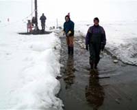
Space Vehicles Directorate Public Affairs Kirtland AFB NM (AFPN) Sep 28, 2006 Improving the prediction of ionospheric-created disturbances is the aim behind two weeks of digging through 3 feet of snow, ice and slush in the tundra of Greenland by four members of the Air Force Research Laboratory Space Vehicles Directorate, with assistance from Danish personnel. Ionospheric-created disturbances disrupt radar and global positioning systems as well as satellite and high frequency communications. Following three and a half years of negotiations with the Danish government, the group of researchers serving with the organization's Battlespace Environment Division, Hanscom Air Force Base, Mass., received approval last year to install equipment measuring the different properties of the ionosphere at Station Nord, a military outpost located in the far northeast portion of the giant isle. "Installing the equipment was a challenge due to the harsh environment where there was snow on top of ice on top of frozen ground. Our team spent a lot of time wading in slush," said Todd Pedersen, research physicist, AFRL's Space Vehicles Directorate. "We needed to dig 4 to 5 feet down in the hardened ground to anchor the equipment." In the polar region, located above the Arctic Circle, instabilities in the ionosphere create structuring of sunlight-produced plasma, which causes significant effects on radio wave transmissions. Similar in form to cumulus clouds, but not visible to the naked eye, these disruptions drift away from the direction of the sun across the polar cap. For the past 20 plus years, the Air Force has conducted ionospheric research at Danish Meteorological Institute sites in western Greenland, and also since the mid-1990s at a civilian facility at Svalbard, a group of islands belonging to the Kingdom of Norway, situated between the Scandinavian nation and the North Pole. Both stations have provided real-time data to the Air Force Weather Agency at Offutt AFB, Neb., but the bulk of the information has been returned months later to the Hanscom AFB-based team. In addition, forecast capabilities at the two locations have experienced a gap in coverage as the ionospheric turbulence moves at 500 meters per second across the polar cap, becoming fully developed by the time it reaches Thule Air Base, the U.S. installation in northwest Greenland. To bridge the lapse, placing instrumentation at Station Nord served as the optimum option. "With the new instruments, we can observe the forces creating the disturbances, as well as how they evolve and we can also observe their impacts on systems such as GPS and radar," said Dr. Pedersen. "We hope to be able to take the data to forecast the creation of ionospheric disturbances." In July the four-person Air Force contingent arrived at Station Nord aboard a Danish Air Force C-130 aircraft. During the next 14 days, the AFRL scientists installed five instruments including an approximately 82 feet by 200 feet ionosonde transmit antenna, capable of determining ionospheric density profiles; an all-sky imager for viewing aurora and ionospheric plasma clouds; and three other systems employed to identify ionospheric scintillation through fluctuations in the strength of radio signals transmitted by various satellites such as GPS. Researchers expect the exterior sensors to produce data for one year at a time, and believe the equipment's output can be extended another 48 months with annual maintenance. Meanwhile, the Station Nord site crew, comprised of five Danish military members, manages the instrument suite, which compiles short summaries, comprised primarily of text with occasional imagery, of ionospheric disruptions every 15 minutes. "Data from Station Nord will allow us to solve the scientific challenges and forecast space weather impacts on a variety of civilian and military systems," said Dr. Pedersen. "The remote geographical location creates an unbroken chain of measurements across the polar cap that allows ionospheric disturbances to be tracked from start to finish in this region." Related Links Solar Science News at SpaceDaily SpaceDaily Search SpaceDaily Subscribe To SpaceDaily Express |
|
| The contents herein, unless otherwise known to be public domain, are Copyright 1995-2005 - SpaceDaily. AFP and UPI Wire Stories are copyright Agence France-Presse and United Press International. ESA Portal Reports are copyright European Space Agency. All NASA sourced material is public domain. Additional copyrights may apply in whole or part to other bona fide parties. Advertising does not imply endorsement, agreement or approval of any opinions, statements or information provided by SpaceDaily on any web page published or hosted by SpaceDaily. Privacy statement |