Subscribe free to our newsletters via your
. 24/7 Space News .


EARTH OBSERVATION
Earth Science Applications Travelogue: Maury Estes
by Molly Porter for Marshall Space Flight Center
Huntsville AL (SPX) May 15, 2014


Bluefin tuna larvae. Image courtesy ROFFS.

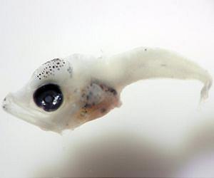
When you think about the beneficiaries of NASA Earth observations, does the Atlantic bluefin tuna (Thunnus thynnus) come to mind? It should! To find more about NASA's connection to the ocean blue, research scientist Maury Estes embarked on a weeklong research cruise in the Gulf of Mexico to learn how fisheries experts, scientists and oceanographers use satellite-derived data in fishery field studies.

Estes is an associate program manager for ecological forecasting in the applied sciences program at NASA's headquarters. While in the field, he will serve as a member of the science team, with regular duties during 12-hour shifts to drop nets and process samples in labs. His thoughts about daily life onboard the research vessel, interviews with crewmembers, pictures and video will be posted here.
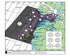
Applied Science
You might be wondering what in the world NASA has to do with marine fisheries. The trip is part of ongoing NASA applied science research focused on possible effects of climate change on Atlantic bluefin tuna and other highly migratory fish species in the Gulf of Mexico and surrounding waters. The goal is reliable ecological forecasts that give decision-makers access to science-based tools for understanding changes in living systems.

NOAA's National Marine Fisheries Service (NMFS) routinely uses satellite observations such as sea surface temperature, topography and ocean color in its surveys and stock assessment process for Atlantic bluefin tuna and other highly migratory fish species.

The applied research project led by Dr. Mitchell Roffer of Roffer's Ocean Fishing Forecasting Service in Melbourne, Florida, aims to enhance this innovative habitat model by applying it to possible climate change scenarios. The goal is reliable forecasting of how habitats might change over the next 100 years.

Roffer's delivers information products using NASA and NOAA satellite observations and computer models downscaled to the Gulf region to direct ships where they're most likely to find Atlantic bluefin tuna larvae.

"The purpose of this cruise is to verify our habitat models by analyzing where and under what conditions larvae are," Roffer said.

Better habitat models mean more reliable forecasting. More reliable forecasts give researchers and decision-makers better tools for understanding living systems.

Why Study Tuna?
The Atlantic bluefin tuna is one of the largest and most valuable fish in the sea. The species is important to commercial and recreational fisheries in the United States and abroad. The species is slow growing with a long life expectancy, making it susceptible to overfishing. Populations of Atlantic bluefin tuna have been declining since the 1970s, necessitating annual fishing quotas.

Despite climate variability, Dr. Roffer explained that bluefin tuna are managed largely under the assumption that ecological parameters do not change over time.

Who is Involved?
The NASA-funded "applications" research project brings together a multi-sector and multi-disciplinary research team, including government, academic and industry partners. The research team is made up of NOAA government fishery experts, managers and satellite researchers; scientists from University of Miami Cooperative Institute of Marine and Atmospheric Sciences and University of South Florida Institute for Marine Remote Sensing; and Roffers' Ocean Fishing Forecasting Service, Inc.

Bon voyage, Maury! You can follow his travelogue here

.


Related Links
Earth at NASA
Earth Observation News - Suppiliers, Technology and Application


Comment on this article via your Facebook, Yahoo, AOL, Hotmail login.

Share this article via these popular social media networks
del.icio.usdel.icio.us DiggDigg RedditReddit GoogleGoogle


EARTH OBSERVATION
Experts demonstrate versatility of Sentinel-1
Paris (ESA) May 12, 2014
From climate change monitoring to supporting humanitarian aid and crisis situations, early data applications from the month-old Sentinel-1A satellite show how the radar mission's critical observations can be used to keep us and our planet safe. Launched from Europe's Spaceport in French Guiana on 3 April, Sentinel-1A is the first satellite in Europe's Copernicus environmental monitoring ne ... read more


EARTH OBSERVATION
LRO View of Earth

Saturn in opposition tonight, will appear next to the moon

Russia to begin Moon colonization in 2030

Astrobotic Partners With NASA To Develop Robotic Lunar Landing Capability

EARTH OBSERVATION
NASA wants greenhouse on Mars by 2021

Reset and Recovery for Opportunity

NASA's Curiosity Rover Drills Sandstone Slab on Mars

Mars mission scientist Colin Pillinger dies

EARTH OBSERVATION
Chris Hadfield's 'Space Oddity' video to be taken off YouTube

'Convergent' Research Solves Problems that Cross Disciplinary Boundaries

Pioneering Test Pilot Bill Dana Dies at Age 83

More Plant Science as Expedition 39 Trio Trains for Departure

EARTH OBSERVATION
The Phantom Tiangong

New satellite launch center to conduct joint drill

China issues first assessment on space activities

China launches experimental satellite

EARTH OBSERVATION
Russia to only use ISS until 2020: official

Ham video premiers on Space Station

NASA Seeks to Evolve ISS for New Commercial Opportunities

Astronauts Complete Short Spacewalk to Replace Backup Computer

EARTH OBSERVATION
Replacing Russian-made rocket engines is not easy

Pre-launch processing begins for the O3b Networks satellites

US sanctions against Russia had no effect on International Launch Services

SHERPA launch service deal to deploy 1200 kilo smallsat payloads

EARTH OBSERVATION
Length of Exoplanet Day Measured for First Time

Spitzer and WISE Telescopes Find Close, Cold Neighbor of Sun

Alien planet's rotation speed clocked for first time

Seven Samples from the Solar System's Birth

EARTH OBSERVATION
'Wolfenstein' videogame a Nazi-fighting adventure

The Tallest Skyscrapers Currently Under Construction

Berkeley Develops Nanoscope To Probe Molecular Scale Chemistry

Regenerating plastic grows back after damage


The content herein, unless otherwise known to be public domain, are Copyright 1995-2014 - Space Media Network. All websites are published in Australia and are solely subject to Australian law and governed by Fair Use principals for news reporting and research purposes. AFP, UPI and IANS news wire stories are copyright Agence France-Presse, United Press International and Indo-Asia News Service. ESA news reports are copyright European Space Agency. All NASA sourced material is public domain. Additional copyrights may apply in whole or part to other bona fide parties. Advertising does not imply endorsement, agreement or approval of any opinions, statements or information provided by Space Media Network on any Web page published or hosted by Space Media Network. Privacy Statement All images and articles appearing on Space Media Network have been edited or digitally altered in some way. Any requests to remove copyright material will be acted upon in a timely and appropriate manner. Any attempt to extort money from Space Media Network will be ignored and reported to Australian Law Enforcement Agencies as a potential case of financial fraud involving the use of a telephonic carriage device or postal service.