| . |  |
. |
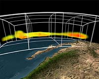
NASA and the National Oceanic and Atmospheric Administration today outlined research that has helped to improve the accuracy of medium-range weather forecasts in the Northern Hemisphere. NASA and NOAA scientists at the Joint Center for Satellite Data Assimilation in Camp Springs, Md., came up with procedures to improve forecasting accuracy. The scientists worked with experimental data from the Atmospheric Infrared Sounder instrument on NASA's Aqua satellite. They found incorporating the instrument's data into numerical weather prediction models improves the accuracy range of experimental six-day Northern Hemisphere weather forecasts by up to six hours, a four-percent increase. The Atmospheric Infrared Sounder is a high-spectral resolution infrared instrument that takes 3-D pictures of atmospheric temperatures, water vapor and trace gases. The instrument data have been officially incorporated into the National Oceanic and Atmospheric Administration's National Weather Service operational weather forecasts. "NASA is assisting the world's weather prediction agencies by providing very detailed, accurate observations of key atmospheric variables that interact to shape our weather and climate," said Dr. Mary Cleave, associate administrator for NASA's Science Mission Directorate. "The forecast improvement accomplishment alone makes the AIRS project well worth the American taxpayers' investment." "This AIRS instrument has provided the most significant increase in forecast improvement in this time range of any other single instrument," said retired Navy Vice Adm. Conrad C. Lautenbacher, Jr., Ph.D., under secretary of commerce for oceans and atmosphere and National Oceanic and Atmospheric Administration administrator. "Climate and weather forecasts are dependent upon our understanding current global ocean and atmosphere conditions," added Lautenbacher. "If we want to be able to predict what the weather will be like in the future, we must adequately define the global conditions today. Satellite data, like AIRS provides, is a vital link for NOAA to take the pulse of the planet continuously." "A four-percent increase in forecast accuracy at five or six days normally takes several years to achieve," said Joint Center for Satellite Data Assimilation Director Dr. John LeMarshall. "This is a major advancement, and it is only the start of what we may see as much more data from this instrument are incorporated into operational forecast models at the National Oceanic and Atmospheric Administration's Environmental Modeling Center." The European Center for Medium-Range Weather Forecasts began incorporating data from the Atmospheric Infrared Sounder into their operational forecasts in October 2003. The center reported an improvement in forecast accuracy of eight hours in Southern Hemisphere five-day forecasts. The Atmospheric Infrared Sounder instrument is the result of more than 30 years of atmospheric research and is led by Dr. Moustafa Chahine of NASA's Jet Propulsion Laboratory, Pasadena, Calif. It is the first in a series of advanced infrared sounders that will provide accurate, detailed atmospheric temperature and moisture observations for weather and climate applications. The Joint Center for Satellite Data Assimilation is operated by the National Oceanic and Atmospheric Administration, NASA and the U.S. Air Force and Navy. The goals of the center are to accelerate the use of observations from Earth-orbiting satellites to improve weather and climate forecasts, and to increase the accuracy of climate data sets. Related Links AIRS SpaceDaily Search SpaceDaily Subscribe To SpaceDaily Express  Vienna (AFP) Aug 22, 2005
The armies of several central and eastern European countries were mobilizing to cope with heavy rains and floods which have killed nearly 70 people in the region this summer, with Romania and Bulgaria the worst hit.
|
| ||||||||||
| The content herein, unless otherwise known to be public domain, are Copyright 1995-2016 - Space Media Network. All websites are published in Australia and are solely subject to Australian law and governed by Fair Use principals for news reporting and research purposes. AFP, UPI and IANS news wire stories are copyright Agence France-Presse, United Press International and Indo-Asia News Service. ESA news reports are copyright European Space Agency. All NASA sourced material is public domain. Additional copyrights may apply in whole or part to other bona fide parties. Advertising does not imply endorsement, agreement or approval of any opinions, statements or information provided by Space Media Network on any Web page published or hosted by Space Media Network. Privacy Statement All images and articles appearing on Space Media Network have been edited or digitally altered in some way. Any requests to remove copyright material will be acted upon in a timely and appropriate manner. Any attempt to extort money from Space Media Network will be ignored and reported to Australian Law Enforcement Agencies as a potential case of financial fraud involving the use of a telephonic carriage device or postal service. |