| . |  |
. |
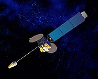
Raytheon's Japanese Advanced Meteorological Imager has been successfully launched on board Japan's Multi-functional Transport Satellite-1 Replacement (MTSAT-1R), built by prime contractor, Space Systems/Loral (SS/L), and is now providing new images of earth. JAMI introduces the next generation of operational GEO (Geosynchronous Earth Orbit) weather imagers and provides enhanced spatial sampling, radiometric sensitivity, Earth coverage and 24-hour observation capability. The JAMI subsystem was developed and produced by the Santa Barbara Remote Sensing division of Raytheon's Space and Airborne Systems business and was provided to prime contractor Space Systems Loral for the Japanese MTSAT-1R satellite in June 2003. MTSAT fulfills a meteorological mission by providing timely, high quality, full-disk multispectral imagery for operational weather needs in Japan, East Asia and Australia, along with a civil aviation mission by relaying digitized voice data and other data for aircraft along with radio navigation signals. "JAMI was successfully produced on an extremely challenging schedule, and we're proud to see it now being deployed," said Ron Ambort, general manager of Santa Barbara Remote Sensing. "Our imager is characterized by an elegant architecture and the use of newer technology for design simplicity and superior performance." JAMI breaks through limitations of earlier geosynchronous weather imagers with significant improvements in many areas, including unprecedented spatial resolution, radiometric sensitivity and calibration. JAMI will transmit 2-km infrared data in normal operating modes and can provide 0.5-km visible band data on demand. Higher spatial resolution data improves cloud edge detection and tracking, which results in more accurate wind drift information, improved capability to describe and forecast behavior of rapidly evolving weather systems, and improved typhoon tracking. JAMI will also enable identification of smaller scale phenomena such as fog, cloud-top thermal gradients, and outflow boundaries. JAMI's high radiometric sensitivity and accurate calibration enable much better cloud top and sea surface temperature measurements, which will improve quantitative precipitation forecasts along with aviation and shipping weather forecasts, especially for regions outside the range of surface-based radars. Improved environmental monitoring provided by JAMI will reduce the impact and cost of natural hazards such as typhoons and forest fires by enabling the best possible warnings and providing information to minimize damage and allow most efficient evacuation. Related Links Raytheon SpaceDaily Search SpaceDaily Subscribe To SpaceDaily Express  Washington DC (SPX) Mar 28, 2005
The National Oceanic and Atmospheric Administration today signed a long-term agreement with the Japan Meteorological Agency to guarantee continuous geostationary satellite coverage of the continental United States and the Western Pacific, in case either agency experiences a spacecraft failure. NOAA is an agency of the U.S. Department of Commerce.
|
| ||||||||||
| The content herein, unless otherwise known to be public domain, are Copyright 1995-2016 - Space Media Network. All websites are published in Australia and are solely subject to Australian law and governed by Fair Use principals for news reporting and research purposes. AFP, UPI and IANS news wire stories are copyright Agence France-Presse, United Press International and Indo-Asia News Service. ESA news reports are copyright European Space Agency. All NASA sourced material is public domain. Additional copyrights may apply in whole or part to other bona fide parties. Advertising does not imply endorsement, agreement or approval of any opinions, statements or information provided by Space Media Network on any Web page published or hosted by Space Media Network. Privacy Statement All images and articles appearing on Space Media Network have been edited or digitally altered in some way. Any requests to remove copyright material will be acted upon in a timely and appropriate manner. Any attempt to extort money from Space Media Network will be ignored and reported to Australian Law Enforcement Agencies as a potential case of financial fraud involving the use of a telephonic carriage device or postal service. |