| . |  |
. |
Lockheed Martin has been awarded a $6 million NASA, 18-month contract to perform design and risk reduction for the agency's Solar Imaging Suite (SIS). The SIS is a diverse set of operational instruments that will fly on the Geostationary Operational Environmental Satellites (GOES)-R Series to provide key information on solar activity, and the effects of the Sun on the earth and near-earth space environment. The first GOES-R launch is scheduled for 2012. The GOES Program is managed by the National Oceanic and Atmospheric Administration (NOAA), which establishes requirements, provides funding and distributes environmental data for the United States. NASA's Goddard Space Flight Center, Greenbelt, Md., procures and manages the acquisition of the GOES satellites for NOAA. "We're pleased and honored to be selected to perform the formulation study for the SIS," said Bruce Jurcevich, SIS program manager at the Lockheed Martin Space Systems Advanced Technology Center (ATC) in Palo Alto. "We look forward to refining the requirements for SIS and providing our customer with the best solution while taking into account cost and overall risk." In recognition of the importance of these data and the challenges associated with providing the SIS, Lockheed Martin assembled a highly capable team with a substantial record of success in providing similar instruments for other missions. The Lockheed Martin Solar and Astrophysics Laboratory (LMSAL) within the ATC is well known for solar instrument development and solar physics research. LMSAL is leading the GOES-R SIS initiative and taking the lead for the study of the GOES-R Solar X-ray Imager (SXI), and currently working on the GOES-N SXI. The University of Colorado's Laboratory for Atmospheric and Space Physics (LASP) is directing the studies of the GOES-R X-ray Sensor (XRS) and Extreme Ultraviolet Sensor (EUVS), bringing to bear their extensive experience with highly accurate solar irradiance measurements using their irradiance instruments aboard several current and future spacecraft. The Naval Research Laboratory (NRL) has decades of experience studying coronal mass ejections (CMEs) and developing and operating space-based coronagraphs. The NRL group is leading the study of the GOES-R Solar Coronagraph (SCOR). Collectively, the team has produced dozens of successful scientific instruments that have contributed to our current understanding of solar activity and the resulting space weather. Data from NOAA's GOES spacecraft provide short-term advance weather warning products to the commercial, educational and public sectors to protect lives, property and the environment, and to foster economic growth and promote educational research. The future GOES-R mission is expected to improve the quality and timeliness of forecasts, expanding the safety and economic security of the public. Along with the Polar Operational Environmental Satellite (POES) and Defense Meteorological Satellite Program (DMSP) polar orbiting weather satellites currently built by Lockheed Martin, GOES is a critical part of the U.S. satellite constellation for weather observations. GOES is, perhaps, the weather satellite most familiar to the American public, as its images and time-lapse sequences are the primary visual material of television weather forecasts. The GOES system, operational since 1975, plays a critical role in weather and environmental forecasting. In orbit, high above the equator, GOES satellites are uniquely positioned to observe the development of hazardous weather, such as hurricanes and severe thunderstorms, and to track their movement and intensity so that major losses of life and property can be reduced or avoided. Related Links Lockheed Martin SpaceDaily Search SpaceDaily Subscribe To SpaceDaily Express  Salzburg Austria (ESA) Sep 16, 2004
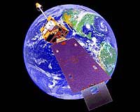
The first Meteosat Second Generation meteorological satellite is today in operational service as Meteosat-8. The data it streams down from 36000 km over Africa's Gulf of Guinea assists not just European weather forecasters but also numerous scientific teams.
|
| ||||||||||
| The content herein, unless otherwise known to be public domain, are Copyright 1995-2016 - Space Media Network. All websites are published in Australia and are solely subject to Australian law and governed by Fair Use principals for news reporting and research purposes. AFP, UPI and IANS news wire stories are copyright Agence France-Presse, United Press International and Indo-Asia News Service. ESA news reports are copyright European Space Agency. All NASA sourced material is public domain. Additional copyrights may apply in whole or part to other bona fide parties. Advertising does not imply endorsement, agreement or approval of any opinions, statements or information provided by Space Media Network on any Web page published or hosted by Space Media Network. Privacy Statement All images and articles appearing on Space Media Network have been edited or digitally altered in some way. Any requests to remove copyright material will be acted upon in a timely and appropriate manner. Any attempt to extort money from Space Media Network will be ignored and reported to Australian Law Enforcement Agencies as a potential case of financial fraud involving the use of a telephonic carriage device or postal service. |