| . |  |
. |
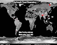
Using data gathered over the past 19 years, Dartmouth Flood Observatory (DFO) experts know that most flooding worldwide happens in July and August, and they can point out where and when floods are likely to occur. "We expect summer floods in what we call monsoonal Asia, which includes most of China, Vietnam, Thailand and parts of India," says G. Robert Brakenridge, a fluvial geomorphologist who is also the founder and director of the DFO. "There will also probably be flooding in sub-Saharan Africa, around the Gulf of Mexico, in the islands of the Caribbean and in Central America." Floods occur every year, and according to the DFO, these events are increasing in frequency and intensity. In 2003, there were nearly 300 flood events, and the trend over the past three years forecasts a busy 2004. Comprehensive data in the DFO's archive make these predictions possible. This archive, the only one like it in the world according to Brakenridge, is a collection of information from satellites, news media and government sources that documents the extent and variety of flooding since 1985. DFO experts use both radar and optical satellites to detect, map, measure and analyze major floods worldwide to create their interactive catalogue. In May of this year, for example, the DFO monitored and tracked the deadly flooding on the island of Hispaniola in the Caribbean that impacted the people of Haiti and the Dominican Republic. The maps generated at Dartmouth clearly illustrated the change in the landscape over the past several years. These maps were also used by the European Space Agency/AlertNet, which works with Reuters to provide relevant satellite imagery to the international humanitarian community. Brakenridge explains that the DFO currently serves three purposes. He and his colleagues at the observatory detect floods, maintain real time maps of current flooding events, and keep a record of these events over time to learn what areas might be susceptible to flooding. Soon, he hopes, a fourth will be possible. "I hope that information from the Dartmouth Flood Observatory will be used to assess global climate change. Our global inventory of flooding events should be useful to figure out whether it's getting worse." Because most of the DFO's data is freely available on the Web, Brakenridge isn't exactly sure how the data is being used, but he gets phone calls and e-mails from people that gives him a hint. He says the maps and accompanying analysis are routinely accessed by people from NGOs (non-governmental organizations) like relief agencies and church groups, the Federal Emergency Management Agency (FEMA), the U.S. Army Corps of Engineers, agencies affiliated with the United Nations, the U.S. Agency for International Development (USAID), and high school and college students where the DFO is part of the curriculum. Related Links Dartmouth Flood Observatory SpaceDaily Search SpaceDaily Subscribe To SpaceDaily Express  Greenbelt MD (SPX) Jun 22, 2004
ASRC Aerospace Corporation has been awarded the National Oceanic and Atmospheric Administration's (NOAA) Engineering and Mission Operations Support Services (EMOSS) II contract.
|
| ||||||||||
| The content herein, unless otherwise known to be public domain, are Copyright 1995-2016 - Space Media Network. All websites are published in Australia and are solely subject to Australian law and governed by Fair Use principals for news reporting and research purposes. AFP, UPI and IANS news wire stories are copyright Agence France-Presse, United Press International and Indo-Asia News Service. ESA news reports are copyright European Space Agency. All NASA sourced material is public domain. Additional copyrights may apply in whole or part to other bona fide parties. Advertising does not imply endorsement, agreement or approval of any opinions, statements or information provided by Space Media Network on any Web page published or hosted by Space Media Network. Privacy Statement All images and articles appearing on Space Media Network have been edited or digitally altered in some way. Any requests to remove copyright material will be acted upon in a timely and appropriate manner. Any attempt to extort money from Space Media Network will be ignored and reported to Australian Law Enforcement Agencies as a potential case of financial fraud involving the use of a telephonic carriage device or postal service. |