| . |  |
. |
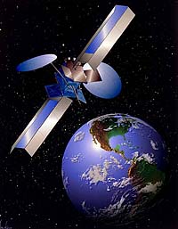
Garmin International Inc., has signed a deal with XM Radio to distribute real-time graphical weather data directly to Garmin marine chartplotters utilizing the XM WX Satellite Weather data service. "Garmin is excited to be the first company to deliver weather data directly to a chartplotter -- without the use of a separate PC," said Gary Kelley, Garmin's director of marketing. "Combined with our award-winning BlueChart marine cartography, the XM WX Satellite Weather data offers boaters a safer and more enjoyable time on the water. We're confident that in the future, serious mariners will come to rely on this weather data, much like they rely on GPS or sonar technology today." XM WX Satellite Weather is the same leading site-specific, analytical weather technology and data that is provided to television meteorologists across the United States. All data is collected from multiple government agencies and commercial providers, which is then analyzed and processed by XM WX partner, WxWorx, using proprietary and patented methods. WxWorx has redundant servers located in the National Climatic Data Center -- a division of the National Oceanic and Atmospheric Administration (NOAA) -- and at its headquarters in Huntsville, Alabama. XM's two satellites in geostationary orbit deliver seamless, redundant coverage nationwide and several hundred miles offshore. In addition, mariners will also have the option of receiving XM Satellite Radio's 120-plus satellite channels of commercial-free music along with premier sports, news, talk, and entertainment -- all delivered and accessed directly from the chartplotter for an additional monthly fee. "The XM WX service makes it easy for boaters to receive continuous, detailed weather information and audio news and entertainment right at the helm," said Roderick MacKenzie, XM's director of advanced applications. "This service will help mariners make better-informed decisions under all weather conditions." The system relays a continuous transmission of more than 15 different types of graphical weather information that can be directly overlaid on the chartplotter, including: Weather information is captured and processed via the new Garmin GDL 30 remote mount receiver and GA 31 pole-mount antenna. The units are totally waterproof, and installation is plug-and-play on the new Garmin Marine Network. For boaters wanting XM Satellite Radio in addition to XM WX weather data, Garmin is offering the GDL 30A -- which provides a unique audio channel interface in addition to weather data on Garmin's next-generation chartplotters. XM WX Satellite Weather data and audio can be accessed on the new Garmin Marine Network, a fully-integrated, ethernet-based system anchored by the new GPSMAP 3010C and GPSMAP 3006C. Users can overlay individual or combined weather data screens directly onto these color, multifunction display (MFD) chartplotters -- so they can see weather conditions at their current location or along a projected path. The GDL 30 is priced at $642.84 (MSRP), and the GDL 30A is available for $857.13 (MSRP). The GPSMAP 3006C is $2285.70 (MSRP) and the GPSMAP 3010C is priced at $2857.13 (MSRP). All components are expected to be available in the second quarter of 2004. The XM WX Satellite Weather Master Mariner service is available for $49.99 per month, with a $50.00 activation fee. Also available are two lower tier packages featuring a subset of the Master Mariner products structured to meet the needs of fishermen and sailors, each for $29.99 per month and a $50.00 activation fee. Subscribers of XM WX receive the Family Plan price for XM audio broadcasts for an additional $6.99 per month, otherwise sold for $9.99 per month. Related Links Garmin XM Weather SpaceDaily Search SpaceDaily Subscribe To SpaceDaily Express 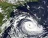 Greenbelt - Apr 13, 2004
During its daytime overpass of the southeast coast of Brazil on March 26, 2004, the Moderate Resolution Imaging Spectroradiometer (MODIS) on the Terra satellite captured this surprising sight: a tropical cyclone.
|
| ||||||||||
| The content herein, unless otherwise known to be public domain, are Copyright 1995-2016 - Space Media Network. All websites are published in Australia and are solely subject to Australian law and governed by Fair Use principals for news reporting and research purposes. AFP, UPI and IANS news wire stories are copyright Agence France-Presse, United Press International and Indo-Asia News Service. ESA news reports are copyright European Space Agency. All NASA sourced material is public domain. Additional copyrights may apply in whole or part to other bona fide parties. Advertising does not imply endorsement, agreement or approval of any opinions, statements or information provided by Space Media Network on any Web page published or hosted by Space Media Network. Privacy Statement All images and articles appearing on Space Media Network have been edited or digitally altered in some way. Any requests to remove copyright material will be acted upon in a timely and appropriate manner. Any attempt to extort money from Space Media Network will be ignored and reported to Australian Law Enforcement Agencies as a potential case of financial fraud involving the use of a telephonic carriage device or postal service. |