| . |  |
. |
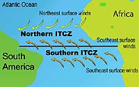
NASA's QuikSCAT satellite has confirmed a 30-year old largely unproven theory that there are two areas near the equator where the winds converge year after year and drive ocean circulation south of the equator. By analyzing winds, QuikSCAT has found a year-round southern and northern Intertropical Convergence Zone. This find is important to climate modelers and weather forecasters because it provides more detail on how the oceans and atmosphere interact near the equator. The Intertropical Convergence Zone (ITCZ) is the region that circles the Earth near the equator, where the trade winds of both the Northern and Southern Hemispheres come together. North of the equator, strong sun and warm water of the equator heats the air in the ITCZ, drawing air in from north and south and causing the air to rise. As the air rises it cools, releasing the accumulated moisture in an almost perpetual series of thunderstorms. Satellite data, however, has confirmed that there is an ITCZ north of the equator and a parallel ITCZ south of the equator. Variation in the location of the ITCZ is important to people around the world because it affects the north-south atmospheric circulation, which redistributes energy. It drastically affects rainfall in many equatorial nations, resulting in the wet and dry seasons of the tropics rather than the cold and warm seasons of higher latitudes. Longer term changes in the ITCZ can result in severe droughts or flooding in nearby areas. "The double ITCZ is usually only identified in the Pacific and Atlantic Oceans on a limited and seasonal basis," said Timothy Liu, of NASA's Jet Propulsion Laboratory and California Institute of Technology, Pasadena, Calif., and lead researcher on the project. In the eastern Pacific Ocean, the southern ITCZ is usually seen springtime. In the western Atlantic Ocean, the southern ITCZ was recently clearly identified only in the summertime. However, QuikSCAT's wind data has seen the southern ITCZ in all seasons across the entire Atlantic Ocean and the eastern Pacific. "QuikSCAT's wind data confirms there is a double ITCZ, and that they exist all year long," Liu said. This is a major find for the science community, as the existence, location, and seasonality of the double ITCZ had remained controversial since 1969. For most of the time, the southern ITCZ is weaker than the northern one, which is why it has been so hard to detect before. The southern ITCZ is weaker because it blows over cooler water that comes up from the lower depths of the ocean, called upwelling. Over cooler water, the air doesn't rise as easily as warm air, and the winds from higher altitudes are mixed less than they would with warmer water and air. Cooler water therefore causes weaker surface winds. Therefore, the surface winds from the south slow down as they approach the equator, and this causes the southern ITCZ because the air gets squeezed together. What is unique about the southern ITCZ is that there is not a north and south wind as with the northern ITCZ. The southern ITCZ only consists of a southern wind coming into the equator. "The convergence of winds in the southern hemisphere creates a counter-clockwise rotation which affects ocean circulation," Liu said. "For the first time, we can give a better explanation of the ocean movements driven by winds." The SeaWinds instrument on QuikSCAT is a specialized microwave radar that measures both the speed and direction of winds near the ocean surface. Launched June 19, 1999, from California's Vandenberg Air Force Base, the spacecraft operates in a Sun-synchronous, near-polar orbit, circling Earth every 100 minutes, taking approximately 400,000 measurements over 90 percent of Earth's surface each day. These findings were presented at the 2002 Western Pacific Geophysics Meeting, Wellington Convention Centre, Wellington, New Zealand, in a session titled "Southern Intertropical Convergence Zones," July 9th. Session A22A-05, Location: MF-LionHV2. The results will be published in a paper entitled, "Double Intertropical Convergence Zones - a New Look Using a Scatterometer," in an upcoming issue of Geophysical Research Letters. Related Links QuikSCAT: Twice-daily maps of QuikSCAT winds over global oceans SpaceDaily Search SpaceDaily Subscribe To SpaceDaily Express  Pasadena - Mar 18, 2002
Wind data for the Pacific Ocean obtained by NASA's Quick Scatterometer spacecraft -- also know as Quikscat -- are documenting episodes of reversed trade winds that are responsible for unseasonable cyclone conditions in the northwest and southwest Pacific, and which may be a precursor of a future El Nino.
|
| ||||||||||
| The content herein, unless otherwise known to be public domain, are Copyright 1995-2016 - Space Media Network. All websites are published in Australia and are solely subject to Australian law and governed by Fair Use principals for news reporting and research purposes. AFP, UPI and IANS news wire stories are copyright Agence France-Presse, United Press International and Indo-Asia News Service. ESA news reports are copyright European Space Agency. All NASA sourced material is public domain. Additional copyrights may apply in whole or part to other bona fide parties. Advertising does not imply endorsement, agreement or approval of any opinions, statements or information provided by Space Media Network on any Web page published or hosted by Space Media Network. Privacy Statement All images and articles appearing on Space Media Network have been edited or digitally altered in some way. Any requests to remove copyright material will be acted upon in a timely and appropriate manner. Any attempt to extort money from Space Media Network will be ignored and reported to Australian Law Enforcement Agencies as a potential case of financial fraud involving the use of a telephonic carriage device or postal service. |