| . |  |
. |
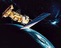
The NOAA-M spacecraft, a polar-orbiting operational earth observation satellite, is set to launched from Vandenberg Air Force Base, Calif. on June 24, 2002 at 5:22pm PST (1822 GMT). Lockheed Martin Space Systems built the NOAA-M satellite, and a Titan 2 rocket, provided under contract to the U.S. Air Force will carry the satellite into orbit. NOAA-M is the latest in the Advanced TIROS-N (ATN) satellite series. All have been designed and built for the National Aeronautics and Space Administration (NASA) and the National Oceanic and Atmospheric Administration (NOAA) by Lockheed Martin companies since the first Television and Infrared Observational Satellite (TIROS) weather satellite launch in April 1960. Most of the spacecraft in the series have operated far longer than originally expected, earning them a reputation as the workhorse of the civil space Earth-imaging inventory. "This team has been totally dedicated to providing NASA and NOAA with satellites to extend NOAA's ability to forecast the weather," says Al Lauer, director of Low Earth Orbit Meteorological Programs for Space Systems-Sunnyvale. "NOAA-M will be the third Polar Operational Environmental Satellite (POES) spacecraft launched in the fifth decade of this program. Our long-standing partnership with our NASA and NOAA customers is a source of genuine pride for Lockheed Martin." A constellation consists of two POES satellites circling the planet in nearly north-south orbits. As the Earth rotates, the entire globe, one swath at a time rolls into view of the satellites' instruments. The instruments are continually sensing the entire depth of the atmosphere and report on the following weather generating factors:
Together these data comprise irreplaceable inputs to the numerical weather forecast model and are vital to medium and long-range forecasting. Separately or in combination, the data are utilized to produce sea-surface temperature maps, ice condition charts, snow cover analysis, vegetation maps and other forecasting and management tools. Additionally, NOAA-M carries an enhanced complement of microwave instruments for the generation of temperature, moisture, surface, and hydrological products in cloudy regions where visible and infrared instruments have decreased capability. NOAA-M also carries search and rescue instruments that are used internationally for locating ships, aircraft, and people in distress. The use of satellites in search and rescue has been instrumental in saving more than 13,000 lives since the inception of the Search and Rescue Satellite-Aided Tracking (SARSAT) system. The NOAA-M satellite will operate in a circular, near-polar orbit of 450 nautical miles above the Earth with an inclination angle of 98.7465 degrees to the equator. Its orbital period, which is the time it takes to complete one orbit of the Earth, will be approximately 101.35 minutes. The NOAA-M orbit is Sun-synchronous, rotating eastward about the Earth's polar axis 0.986 degrees each day, approximately the same rate and direction as the Earth's average daily rotation about the Sun. The rotation keeps the satellite in a constant position with reference to the Sun for constant scene illumination throughout the year. NASA's Goddard Space Flight Center, in Greenbelt, Md., is responsible for the procurement, development, launch services, and verification testing of the spacecraft, instruments, and unique ground equipment. Following deployment of the spacecraft from the launch vehicle, Goddard is responsible for the mission operation phase leading to injection of the satellite into orbit and initial in-orbit satellite checkout and evaluation. Following the launch and a comprehensive on-orbit verification period that lasts 45 days, NASA will turn operational control of the satellites over to NOAA. NOAA will operate the satellites from the Satellite Operations Control Center in Suitland, Md., along with the nation's other environmental satellites that it operates. NOAA's environmental satellite system is composed of two types of satellites: Geostationary Operational Environmental Satellites (GOES) for national, regional, short-range warning and "now-casting"; and Polar Operational Environmental Satellites (POES) for global, long-term forecasting and environmental monitoring. Both GOES and POES are necessary for providing a complete global weather monitoring system. Both also carry search and rescue instruments to relay signals from people in distress. Lockheed Martin Space Systems Company is one of the major operating units of Lockheed Martin Corporation. Space Systems designs, develops, tests, manufactures, and operates a variety of advanced technology systems for military, civil and commercial customers. Chief products include a full-range of space launch systems, including heavy-lift capability, ground systems, remote sensing and communications satellites for commercial and government customers, advanced space observatories and interplanetary spacecraft, fleet ballistic missiles and missile defense systems. Related Links Lockheed Martin Space Systems-Sunnyvale SpaceDaily Search SpaceDaily Subscribe To SpaceDaily Express  Washington - Mar 18, 2002
NOAA has the primary responsibility within the federal government to routinely provide climate forecasts and products to the nation. Most parts of NOAA are in some way involved in El Nino research, monitoring and prediction.
|
| ||||||||||
| The content herein, unless otherwise known to be public domain, are Copyright 1995-2016 - Space Media Network. All websites are published in Australia and are solely subject to Australian law and governed by Fair Use principals for news reporting and research purposes. AFP, UPI and IANS news wire stories are copyright Agence France-Presse, United Press International and Indo-Asia News Service. ESA news reports are copyright European Space Agency. All NASA sourced material is public domain. Additional copyrights may apply in whole or part to other bona fide parties. Advertising does not imply endorsement, agreement or approval of any opinions, statements or information provided by Space Media Network on any Web page published or hosted by Space Media Network. Privacy Statement All images and articles appearing on Space Media Network have been edited or digitally altered in some way. Any requests to remove copyright material will be acted upon in a timely and appropriate manner. Any attempt to extort money from Space Media Network will be ignored and reported to Australian Law Enforcement Agencies as a potential case of financial fraud involving the use of a telephonic carriage device or postal service. |