| . |  |
. |
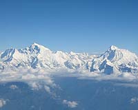
A team of geophysicists at the University of Colorado at Boulder has developed a new technique to visualize the colliding rock bodies beneath the Himalaya with unprecedented detail, answering a number of questions about the world's highest mountains and providing a new tool for assessing earthquake hazards. The study, "Imaging the Indian Subcontinent Beneath the Himalaya" appears in the June 30 issue of the journal Nature. Anne Sheehan, Roger Bilham, Vera Schulte-Pelkum and Gaspar Monsalve of CU-Boulder's Cooperative Institute for Research in Environmental Sciences and department of geological sciences worked on the project along with scientists from the State University of New York at Binghamton and Kathmandu, Nepal. "We imaged the boundary between the Indian and Asian tectonic plates by developing a new technique that highlights strongly deformed rocks beneath Earth's surface, and applied it to data we collected with a network of temporary seismic sensors deployed in Nepal and Tibet," said Schulte-Pelkum, the paper's lead author and a CIRES researcher. The network included 29 broadband seismometers operated by the CU-Boulder and SUNY Binghamton teams. About 1,700 earthquakes from as far away as Europe, Alaska and Japan were recorded during an 18-month period starting in 2001. The study was funded primarily by the National Science Foundation. "Our images of the crust and upper mantle show how the upper Indian crust fragments and is incorporated in the Himalaya, while the lower crust slides under Tibet and undergoes alterations that may help explain how the plateau maintains its high altitude," Schulte-Pelkum said. Sheehan said Schulte-Pelkum developed a truly novel method to visualize the forces at work underneath the Himalaya. "It's very exciting, and it's something we can use elsewhere to analyze shear in the crust." Shear zones are similar to faults, Schulte-Pelkum said. Faults are brittle structures at or near the surface of the earth, while shear zones are found at depths of 10 miles or more where heat causes more ductile, or flowing, rock movement. In subduction zones such as where India and Asia collide, however, earthquakes along brittle faults can occur at depth because rock temperatures are cooler, the researchers said. The collision of India into Asia forms the Himalaya, the world's highest mountain chain, and Tibet, the world's largest high plateau, Schulte-Pelkum explained. "From surface geology, we know that India dives under Asia. In Nepal, this slip is expressed in very large, destructive earthquakes that occur somewhere along the base of the mountains a few times a century." However, the infrequency of the tremors had left scientists with few clues as to the structure of the region. "During the interval between these earthquakes, the shallow fault between underthrusting India and overriding Asia is seismically quiet and difficult to detect," Schulte-Pelkum said. Sheehan explained that until now, geophysicists could analyze the movement of rock bodies only on the surface, where deformation can be directly observed. With the team's new method, geophysicists can study the deep crust and determine the direction rocks are being sheared. The shearing is similar to a deck of cards being spread out on a table, Sheehan explained. "We can see how the deep crust has moved. Seeing where these structures are and how they have moved in the subsurface helps us better understand where local hazards are. "If we can more accurately calculate the subsurface geometries, we can improve our estimations of how the ground will shake during an earthquake. We can't predict earthquakes, but we can get a better idea of how an earthquake's energy will radiate," said Sheehan, an associate professor of geological sciences at CU-Boulder and a CIRES researcher. "The Los Angeles Basin has all sorts of folds and faults and subsurface shear, so it would be another potential place to apply some of these techniques to get high-resolution images," Sheehan said. Related Links University of Colorado at Boulder SpaceDaily Search SpaceDaily Subscribe To SpaceDaily Express  Banda Aceh, Indonesia (AFP) Jun 25, 2005
Indonesia, hardest hit by the deadly tsunamis in December, on Saturday commemorated six months since the disaster and announced 172 reconstruction projects worth 585 million dollars.
|
| ||||||||||
| The content herein, unless otherwise known to be public domain, are Copyright 1995-2016 - Space Media Network. All websites are published in Australia and are solely subject to Australian law and governed by Fair Use principals for news reporting and research purposes. AFP, UPI and IANS news wire stories are copyright Agence France-Presse, United Press International and Indo-Asia News Service. ESA news reports are copyright European Space Agency. All NASA sourced material is public domain. Additional copyrights may apply in whole or part to other bona fide parties. Advertising does not imply endorsement, agreement or approval of any opinions, statements or information provided by Space Media Network on any Web page published or hosted by Space Media Network. Privacy Statement All images and articles appearing on Space Media Network have been edited or digitally altered in some way. Any requests to remove copyright material will be acted upon in a timely and appropriate manner. Any attempt to extort money from Space Media Network will be ignored and reported to Australian Law Enforcement Agencies as a potential case of financial fraud involving the use of a telephonic carriage device or postal service. |