| . |  |
. |
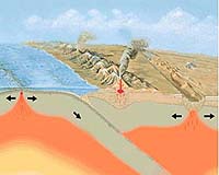
The earthquake that generated the Sumatran-Andaman Islands tsunami caused massive devastation, but exactly what happened beneath the ocean is the focus of modeling activities by an international team of geoscientists. "The earthquake rupture ran a distance equivalent to the distance from Jacksonville, Florida to Boston, Mass.," says Charles J. Ammon, associate professor of geosciences at Penn State. "This earthquake lasted just under 10 minutes, while most large earthquakes take only a few seconds and movement probably continued past that which we can determine from seismic information." Ammon and his colleagues looked at what happened during the Sumatra-Andaman Earthquake on Dec. 26, 2004 and the subsequent earthquake on March 28, 2005, using a variety of models. "We were trying to map out spatially and temporally what was going on," he adds. "The last earthquake in this size range happened more than forty years ago. This is the first time these models could be constructed for such a large earthquakes." Previous earthquakes in the range of the Sumatra-Andaman great earthquake occurred in Kamchatka, Russia in 1952; the Aleutians in 1957; southern Chile in 1960, and Prince William Sound, Alaska in 1964, long before current computational methods for modeling earthquakes were possible. Also, during the earlier large earthquakes, groups such as the Incorporated Research Institutes for Seismology, a National Science Foundation-supported group, and the Federation of Digital Broadband Seismographic Networks, an international group, did not exist. These two groups provided the global seismological data that made the models possible. The researchers report in a special section of today's (May 20) issue of Science that "the 25 December 2004 Sumatra-Andaman and the 28 March 2005 earthquakes produced the most extensive high-quality broadband seismic data ever recorded for great earthquakes." Great earthquakes usually occur along subduction zones and the Sumatra-Andaman earthquake was no exception. Subduction occurs when one of the Earth's tectonic plates slides beneath another of the Earth's plates. In this case the eastern edge of the Indo-Australian plate is sliding beneath the western edge of the southeastern Eurasian plate. The researchers found that the earthquake originated and was strongest just north and west of the island of Sumatra, Indonesia and decreased in strength as it ruptured north to the Nicobar and Andaman Islands, India in the Bay of Bengal. "The earthquake in Dec. 2004 stared slowly with relatively little slip in the first minute," says Ammon. "After 40 to 60 seconds, there was a large amount of energy released." Usually, this subduction fault stays locked between earthquakes, but away from the fault, the plates move at a rate of 1.5 to 2 inches a year. Pressure builds up at the fault over the years until, during an earthquake, they abruptly slip past each other, one going downward and the other moving upward. This creates not only horizontal, but vertical movement during an earthquake. In some places, the Sumatra-Andaman earthquake moved nearly 50 feet in a combination of horizontal and vertical motion. The researchers used different approaches and different data sets to create their models. Their goal was to map out the rupture history and variation along the fault. Ammon created a 1-dimensional model using seismic surface wave data, an Oxford University team created a 2-dimensional model using seismic body wave data and California Institute of Technology and URS Corporation used different combinations of body and surface waves for their models. The models showed that the length of the first earthquake was about 960 miles, began just northwest of Sumatra and moved through the Nicobar Islands to the Andaman Islands decreasing in intensity. Fault movement from this earthquake was nearly all north of the epicenter. The largest slip, that of about 50 feet, occurred just off Sumatra. The models also showed that the March 2005 earthquake began south of the first earthquake and was much shorter in both time and space. These are the largest two earthquakes recorded on modern equipment. The models suggest a speed of one to two miles per second for the speed at which the earthquake expanded northward. The models also suggest that the fault continued to move, albeit much more slowly long after the seismic signals from the earthquake became too slow to record. "We were lucky to have lots of data to use for our models," says Ammon. "We had a very broad range of frequencies available from which to draw our data." Besides Ammon, the researchers included Ji Chen, Vala Hjorteifsdottir, Hiroo Kanamori, Don Helmberger Cal Techand Sidao Ni, Cal Tech and University of Science and Technology, China; Hong-Kie Thio and Gene Ichinose, URS Corporation; David Robinson and Shamita Das, Oxford University; Thorne Lay, University of California, Santa Cruz; Jascha Polet, Institute for Crustal Studies, and David Wald, U. S. Geological Survey. Related Links Penn State SpaceDaily Search SpaceDaily Subscribe To SpaceDaily Express  Pasadena CA (JPL) - May 19, 2005
New NASA research confirms that northern metropolitan Los Angeles is being squeezed at a rate of 5 millimeters (0.2 inches) a year, straining an area between two earthquake faults that serve as geologic bookends north and south of the affected region.
|
| ||||||||||
| The content herein, unless otherwise known to be public domain, are Copyright 1995-2016 - Space Media Network. All websites are published in Australia and are solely subject to Australian law and governed by Fair Use principals for news reporting and research purposes. AFP, UPI and IANS news wire stories are copyright Agence France-Presse, United Press International and Indo-Asia News Service. ESA news reports are copyright European Space Agency. All NASA sourced material is public domain. Additional copyrights may apply in whole or part to other bona fide parties. Advertising does not imply endorsement, agreement or approval of any opinions, statements or information provided by Space Media Network on any Web page published or hosted by Space Media Network. Privacy Statement All images and articles appearing on Space Media Network have been edited or digitally altered in some way. Any requests to remove copyright material will be acted upon in a timely and appropriate manner. Any attempt to extort money from Space Media Network will be ignored and reported to Australian Law Enforcement Agencies as a potential case of financial fraud involving the use of a telephonic carriage device or postal service. |