| . |  |
. |
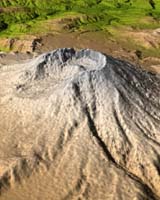
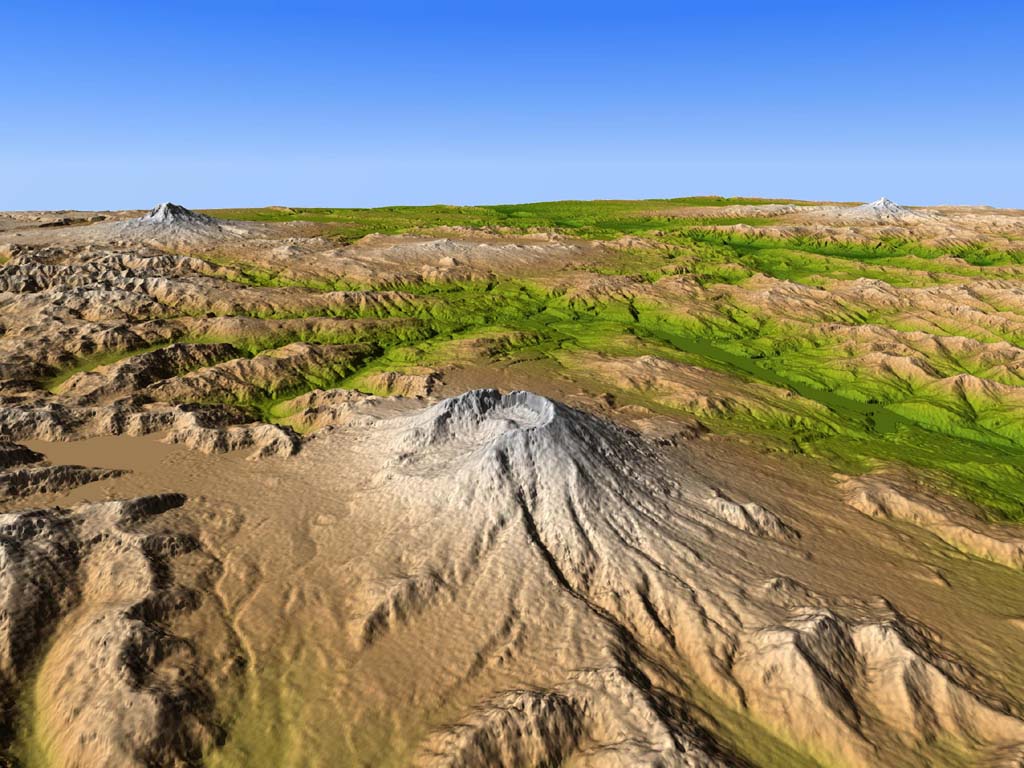
Mount Saint Helens is a prime example of how Earth's topographic form can greatly change even within our lifetimes. The mountain is one of several prominent volcanoes of the Cascade Range that stretches from British Columbia, Canada, southward through Washington, Oregon, and into northern California. Mount Adams (left background) and Mount Hood (right background) are also seen in this view, which was created entirely from elevation data produced by the Shuttle Radar Topography Mission. Prior to 1980, Mount Saint Helens had a shape roughly similar to other Cascade peaks, a tall, bold, irregular conic form that rose to 2950 meters (9677 feet). However, the explosive eruption of May 18, 1980, caused the upper 400 meters (1300 feet) of the mountain to collapse, slide, and spread northward, covering much of the adjacent terrain (lower left), leaving a crater atop the greatly shortened mountain. Subsequent eruptions built a volcanic dome within the crater, and the high rainfall of this area lead to substantial erosion of the poorly consolidated landslide material. Eruptions at Mount Saint Helens subsided in 1986, but renewed volcanic activity here and at other Cascade volcanoes is inevitable. Predicting such eruptions still presents challenges, but migration of magma within these volcanoes often produces distinctive seismic activity and minor but measurable topographic changes that can give warning of a potential eruption. Three visualization methods were combined to produce this image: shading of topographic slopes, color coding of topographic height, and then projection into a perspective view. The shade image was derived by computing topographic slope in the northeast-southwest (left to right) direction, so that northeast slopes appear bright and southwest slopes appear dark. Color coding is directly related to topographic height, with green at the lower elevations, rising through yellow and tan, to white at the highest elevations. The perspective view simulates the geometry of the surface as it would be viewed on a clear day. Elevation data used in this image were acquired by the Shuttle Radar Topography Mission aboard the Space Shuttle Endeavour, launched on Feb. 11, 2000. SRTM used the same radar instrument that comprised the Spaceborne Imaging Radar-C/X-Band Synthetic Aperture Radar (SIR-C/X-SAR) that flew twice on the Space Shuttle Endeavour in 1994. SRTM was designed to collect 3-D measurements of the Earth's surface. To collect the 3-D data, engineers added a 60-meter (approximately 200-foot) mast, installed additional C-band and X-band antennas, and improved tracking and navigation devices. The mission is a cooperative project between NASA, the National Geospatial-Intelligence Agency (NGA) of the U.S. Department of Defense and the German and Italian space agencies. It is managed by NASA's Jet Propulsion Laboratory, Pasadena, Calif., for NASA's NASA's Science Mission Directorate, Washington, D.C.
Related Links SpaceDaily Search SpaceDaily Subscribe To SpaceDaily Express
|
| ||||||||||
| The content herein, unless otherwise known to be public domain, are Copyright 1995-2016 - Space Media Network. All websites are published in Australia and are solely subject to Australian law and governed by Fair Use principals for news reporting and research purposes. AFP, UPI and IANS news wire stories are copyright Agence France-Presse, United Press International and Indo-Asia News Service. ESA news reports are copyright European Space Agency. All NASA sourced material is public domain. Additional copyrights may apply in whole or part to other bona fide parties. Advertising does not imply endorsement, agreement or approval of any opinions, statements or information provided by Space Media Network on any Web page published or hosted by Space Media Network. Privacy Statement All images and articles appearing on Space Media Network have been edited or digitally altered in some way. Any requests to remove copyright material will be acted upon in a timely and appropriate manner. Any attempt to extort money from Space Media Network will be ignored and reported to Australian Law Enforcement Agencies as a potential case of financial fraud involving the use of a telephonic carriage device or postal service. |