| . |  |
. |
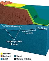
About 25 miles beneath the Earth's surface is a discrete boundary between the planet's rocky crust and the mantle below that geologists call the Moho. But in the southern end of California's San Joaquin Valley, the Moho just isn't there, reports a team of geologists. "The Moho is missing," said team leader George Zandt, a professor of geosciences at the University of Arizona in Tucson. It's the first report of such a disappearance in California. Zandt said the Moho vanished because of the drip. Drip is the term geologists use for a place where the upper portion of the Earth's mantle flows deeper into the mantle, pulling part of the overlying crust down with it. Seen in cross-section, a mantle drip looks like a drip of paint. Under the approximately 60-mile-diameter basin around Visalia, Calif., the Earth's crust is being dragged into a mantle drip, thereby obliterating the nicely delineated Moho found at other crust-mantle boundaries. Given that the drip has been oozing downward for 3 to 3.5 million years, there's no reason to worry that the San Joaquin Valley will soon be sucked into the depths of the earth. But figuring out exactly what is going on underneath that part of California required connecting several geological observations, including the existence of volcanic fields in the southern Sierra Nevada, the valley's subsidence, and the fact that, unlike the other rivers that flow west from the Sierras, rivers just east of the valley drain into the valley rather than running toward San Francisco Bay. The team's finding helps explain how the Sierra Nevada came to be and provides scientists with additional insight into a little-known mountain-building process, said Zandt. A report on the team's work will be published in the Sept. 2 issue of the journal Nature. Zandt's co-authors are Hersh Gilbert, a research associate in the UA department of geosciences, Mihai Ducea, an associate professor of geosciences at UA, and Thomas J. Owens of the University of South Carolina, Jason Saleeby of the California Institute of Technology and Craig H. Jones of the University of Colorado in Boulder. The research was funded by the National Science Foundation. The team already knew that, underneath the southern end of the San Joaquin Valley, the crust tilted westward. But the researchers didn't know exactly what the crust-mantle interface looked like at that spot. So Gilbert peered into the deep doings of crust and mantle by using nine months' worth of seismograph recordings from 25 stations around the valley. The instruments recorded hundreds of earthquakes from far and wide. By analyzing earthquake records, geologists can learn about the rocks that the seismic waves traveled through to reach the recording stations. For Gilbert's purposes, not just any old earthquake would do - he wanted earthquakes that approached the seismograph from underneath, meaning that the waves had traveled deep through the mantle coming up nearly vertically beneath the recording instrument. Therefore many of the earthquakes of interest came from the South Pacific and the areas around Japan and South America. The quake had to be big enough, too - of a magnitude 5.5 or greater. Because the mantle has a different composition than the crust, an earthquake wave changes shape, in a sense making a little hiccup, when it hits the mantle-crust boundary, the Moho. Gilbert used those recorded hiccups to map how deep the Moho runs, starting east of the Sierras and continuing west under the San Joaquin Valley. Gilbert's results were surprising, Zandt said. "We saw the Moho underneath most of the Sierras, but as we go underneath the western foothills, it just disappears over the drip." Naturally, the team wanted to figure out where the Moho went. Because the geologists' seismic imaging techniques could no longer detect the Moho, the team turned to other evidence to explain the disappearance. Scientists already knew that the drip was underneath Visalia, Calif., and that the valley's subsidence centered there. Previous research had shown that the valley's sediments started being deposited about the same time the drip started. So the team just put those facts together with their startling new finding. "We suggest that the drip is pulling down the crust, smearing out the Moho and causing subsidence at the surface," Zandt said. He added, "Interestingly, this downward pull is also tilting the whole Sierra Nevada westward, raising the eastern edge of the mountain range. We think that is why Mount Whitney, the highest point in the lower 48, is located next to the drip." Related Links University of Arizona SpaceDaily Search SpaceDaily Subscribe To SpaceDaily Express  Edmonton AB (SPX) Jul 29, 2004
Researchers at the University of Alberta have found evidence that a 2,000-kilometre corridor stretching diagonally across northern Canada was under tremendous pressure to split in two about 2.7 billion years ago. It is the first evidence suggesting enormous continental landforms and plate tectonics existed that long ago.
|
| ||||||||||
| The content herein, unless otherwise known to be public domain, are Copyright 1995-2016 - Space Media Network. All websites are published in Australia and are solely subject to Australian law and governed by Fair Use principals for news reporting and research purposes. AFP, UPI and IANS news wire stories are copyright Agence France-Presse, United Press International and Indo-Asia News Service. ESA news reports are copyright European Space Agency. All NASA sourced material is public domain. Additional copyrights may apply in whole or part to other bona fide parties. Advertising does not imply endorsement, agreement or approval of any opinions, statements or information provided by Space Media Network on any Web page published or hosted by Space Media Network. Privacy Statement All images and articles appearing on Space Media Network have been edited or digitally altered in some way. Any requests to remove copyright material will be acted upon in a timely and appropriate manner. Any attempt to extort money from Space Media Network will be ignored and reported to Australian Law Enforcement Agencies as a potential case of financial fraud involving the use of a telephonic carriage device or postal service. |