| . |  |
. |
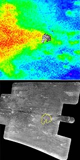
The Cassini spacecraft carried the European Space Agency's Huygens probe to Saturn and released it in December 2004. The probe landed on Titan Jan. 14, 2005, acquiring a set of images using the descent imager/spectral radiometer camera as it parachuted to the surface. As Cassini continued to orbit Saturn, its imaging science subsystem and visual and infrared mapping spectrometer mapped the region where the Huygens probe landed. On Friday, Oct. 28, 2005, Cassini's radar instrument provided the highest resolution orbital data yet of this area. The two images shown here tell the story. On the left, in color, is a composite of the imaging camera and infrared data (red areas are brighter and blue darker, as seen in infrared). On the right is the synthetic aperture radar image. The Huygens descent images are shown inset on the left image and outlined in yellow on the right. The magenta cross in both images shows the best estimate of the actual Huygens landing site. This is a preliminary result, based on the best information available at the present time. In the left image, the brighter areas seen by the Huygens camera correspond to the large area depicted in red and yellow. On closer inspection, bright features within the Huygens mosaic seem to correspond to smaller features in the map composed of data from the visual and infrared spectrometer and imaging camera. On the right, the correspondence is less clear. In radar images bright features are usually rougher, so one would not necessarily expect an obvious connection.
Tectonic Features
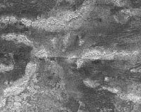
The low-lying terrain between the ridges is covered in dark streaks, which could be dunes formed by wind. The streaks, spaced 1 to 2 kilometers apart (0.6 to 1 mile), curve between patches of the bright terrain, which probably act as topographic barriers. This image is 400 kilometers (250 miles) across and 275 kilometers-wide (170 miles). It is located 8 degrees south latitude and 215 degrees west longitude. Related Links Cassini-Huygens at JPL Cassini Imaging Team SpaceDaily Search SpaceDaily Subscribe To SpaceDaily Express  Moffett Field CA (SPX) Nov 01, 2005
About two years ago, before the Huygens probe arrived at Titan, Henry Roe, a graduate student I was working with at Berkeley, discovered clouds on Titan. He was the first person to get images of what he thought were clouds on the south pole.
|
| |||||||||||
| The content herein, unless otherwise known to be public domain, are Copyright 1995-2016 - Space Media Network. All websites are published in Australia and are solely subject to Australian law and governed by Fair Use principals for news reporting and research purposes. AFP, UPI and IANS news wire stories are copyright Agence France-Presse, United Press International and Indo-Asia News Service. ESA news reports are copyright European Space Agency. All NASA sourced material is public domain. Additional copyrights may apply in whole or part to other bona fide parties. Advertising does not imply endorsement, agreement or approval of any opinions, statements or information provided by Space Media Network on any Web page published or hosted by Space Media Network. Privacy Statement All images and articles appearing on Space Media Network have been edited or digitally altered in some way. Any requests to remove copyright material will be acted upon in a timely and appropriate manner. Any attempt to extort money from Space Media Network will be ignored and reported to Australian Law Enforcement Agencies as a potential case of financial fraud involving the use of a telephonic carriage device or postal service. |