| . |  |
. |
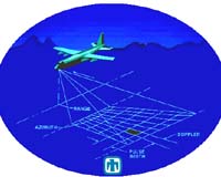
A radar, originally developed by the National Nuclear Security Administration's Sandia National Laboratories for military surveillance and reconnaissance applications, is helping a volunteer search and rescue group save lives. Rapid Terrain Visualization (RTV) precision-mapping synthetic aperture radar (SAR) data was used for the first time last November by the Albuquerque Mountain Rescue Council (AMRC) to help find and rescue a hiker stranded in the dark in the Sandia Mountains in New Mexico. SAR experts at Sandia say the same technology could map other mountainous terrain around the country and be used in search and rescue missions there. The Sandia Mountain effort started with a conversation between Dale Dubbert of Sandia's SAR Sensor Technologies Department, a former rescue council volunteer, and Sandia researcher Steve Attaway, a long-time group member. "We talked about Sandia's capabilities to do precision terrain maps and realized that this technology could be useful in search and rescue missions," Dubbert says. "It had the potential of providing detailed information about terrain where searches are underway, including heights, locations of crevices and cliffs, and even different types of vegetation." The RTV mapping system uses interferometric synthetic aperture radar (IFSAR). Two antennae offset in elevation aboard a moving aircraft allow the measurement of target height, as well as east-west and north-south position like conventional SAR. This produces a 3-D map that shows terrain details. The IFSAR maps have an absolute height accuracy of less than two meters and a relative accuracy of less than one meter. "This is an order of magnitude precision improvement over the standard USGS topographical maps generally used in search and rescue missions," Dubbert says. No other mapping system in the world achieves this level of accuracy combined with a high area coverage rate and real-time processing, says Dubbert. The IFSAR can map day or night and through cloud cover. It was Dubbert who provided the AMRC map data of the Sandia Mountains, obtained while the RTV SAR was installed on a deHavilland DHC-7 Army aircraft. He gave the council a CD of the maps last year. A few months later, on a chilly November evening, the search and rescue group used the precision maps for the first time. Attaway says he got a call just before sundown telling him that a hiker was lost in the Sandia Mountains, and his help was needed for a rescue. After collecting additional information on the hiker's location, he took a few minutes to create detailed RTV SAR maps. He zoomed in on the area where the man was believed to be and printed out color maps of the location. Attaway then went to the Sandia tram (aerial lift that takes people from the base of the Sandia Mountains to the peak), located on the west side of the mountains where the rescuers were gathering, and took the tram up to the peak. "The hiker was climbing the mountain using the tram cables as a guide for off-trail hiking," Attaway says. "He apparently became lost while attempting to follow the tram towers and used his cell phone to call for help. We spotted him from the tram as he waved his flashlight so we would notice him. But seeing him and getting to him were two different things." The terrain in the area where the hiker was lost is extremely rugged. Members of the rescue group are experts in using compasses, GPS, and topographic maps, but even for them the terrain was difficult to navigate. AMRC President Bill Scherzinger, another Sandia employee who also participated in the rescue mission, says that's when the crew turned to the RTV SAR maps for help. "The detail available helped us make our way to the man," Scherzinger says. "The maps were color-coded for height and gave estimates of ground roughness. They also distinguished individual rock formations - known to the rock climbers in our group - that are not seen on the topographic maps." The initial plan was to have rescuers ride the tram to the top of the mountain and then hike down to the stranded hiker's location. However, when they determined that the man was not near the bottom of the canyon, but instead at the top of a ridge called Dragon's Tail, plans changed. The hiker was 100 feet down from the top in a narrow slot that was impossible to access without technical rock climbing. "Using the RTV SAR maps to help us plan the rescue, we sent one team to nearby Echo Canyon to better determine the exact location of the hiker. A second team went along the treacherous ridgeline of the Dragon's tail. The first team made voice contact with the man from the bottom of the bluffs at about 3 a.m.," Scherzinger says. The second team rappelled to the hiker at 6 a.m., following a ridgeline that was one of the most difficult and risky routes the rescue group had ever attempted. Another four-hour hike using climbing gear and ropes was necessary to bring the man to safety. The entire rescue took more than 12 hours. "There's no doubt that if we didn't have the RTV SAR maps, reaching the stranded hiker would have been even more difficult than it was," Scherzinger says. "The 3-D detail of SAR maps saved us time while we were planning our route. We expect to continue to use the RTV SAR in future rescue missions where it seems like it will help the most." Related Links Sandia National Laboratories SpaceDaily Search SpaceDaily Subscribe To SpaceDaily Express 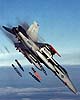 China Lake CA (SPX) Jul 20, 2004
A revolutionary Raytheon radar that scans the skies at nearly the speed of light is navigating through flight tests aboard the US. Navy F/A-18 E/F Super Hornet in anticipation of operational readiness by September 2006.
|
| ||||||||||
| The content herein, unless otherwise known to be public domain, are Copyright 1995-2016 - Space Media Network. All websites are published in Australia and are solely subject to Australian law and governed by Fair Use principals for news reporting and research purposes. AFP, UPI and IANS news wire stories are copyright Agence France-Presse, United Press International and Indo-Asia News Service. ESA news reports are copyright European Space Agency. All NASA sourced material is public domain. Additional copyrights may apply in whole or part to other bona fide parties. Advertising does not imply endorsement, agreement or approval of any opinions, statements or information provided by Space Media Network on any Web page published or hosted by Space Media Network. Privacy Statement All images and articles appearing on Space Media Network have been edited or digitally altered in some way. Any requests to remove copyright material will be acted upon in a timely and appropriate manner. Any attempt to extort money from Space Media Network will be ignored and reported to Australian Law Enforcement Agencies as a potential case of financial fraud involving the use of a telephonic carriage device or postal service. |