| . |  |
. |
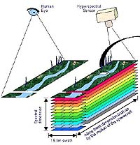
The Northrop Grumman-built Hyperion hyperspectal imager aboard NASA's Earth Observing-1 satellite celebrated its third anniversary on-orbit Nov. 21. Originally intended to be on-orbit for one year, Hyperion has now operated for 300 percent of its original mission life. During its years on-orbit, Hyperion has taken more than 10,000 images in 220 spectral bands of features and phenomena on Earth, including volcanoes, forests, fires and vegetation. These images have been supplied to commercial users and science teams around the country through a partnership between NASA and the United States Geological Survey. Hyperspectral imaging helps improve productivity and management of industries based on natural resources, such as agriculture, forestry and mining, as well as defense. By providing very detailed information, hyperspectral imaging enables users to make informed decisions, which are cost-effective and beneficial in the long run. "Hyperion has done a great job on-orbit for NASA and the scientific community, producing a wealth of data for remote sensing purposes," said Jay Marmo, who led development of the prototype for Hyperion at Northrop Grumman Space Technology. "It has also demonstrated the exceptional reliability that characterizes our systems, spacecraft and sensors." Hyperion fulfilled its mission as a part of NASA's New Millennium Program after one year on-orbit and has been in an extended mission since then. The New Millennium Program was designed to validate revolutionary technologies that will reduce the cost and increase the capabilities for future land imaging. Northrop Grumman has decades of experience as both an instrument developer and a systems prime contractor, building highly reliable spacecraft and sensors for remote sensing missions. The company has designed and developed airborne and spaceborne hyperspectral instruments since 1989. Its hyperspectral instruments have completed thousands of hours of operations on many platforms, taking images of metropolitan, agricultural and environmentally sensitive areas. Based in Redondo Beach, Calif., Northrop Grumman Space Technology is leader in the design and development of systems, satellites and sensors for remote sensing and environmental missions. Related Links Northrop Grumman Space Technology SpaceDaily Search SpaceDaily Subscribe To SpaceDaily Express  Munich - Nov 27, 2003
EADS Astrium has successfully developed an Airborne Synthetic Aperture Radar (SAR), called the MicroSAR Airborne Demonstrator, which can be applied to both spaceborne and airborne SAR systems, including the spaceborne MicroSAR system and the airborne QuaSAR system. This technology is a major breakthrough in low cost SAR systems.
|
| ||||||||||
| The content herein, unless otherwise known to be public domain, are Copyright 1995-2016 - Space Media Network. All websites are published in Australia and are solely subject to Australian law and governed by Fair Use principals for news reporting and research purposes. AFP, UPI and IANS news wire stories are copyright Agence France-Presse, United Press International and Indo-Asia News Service. ESA news reports are copyright European Space Agency. All NASA sourced material is public domain. Additional copyrights may apply in whole or part to other bona fide parties. Advertising does not imply endorsement, agreement or approval of any opinions, statements or information provided by Space Media Network on any Web page published or hosted by Space Media Network. Privacy Statement All images and articles appearing on Space Media Network have been edited or digitally altered in some way. Any requests to remove copyright material will be acted upon in a timely and appropriate manner. Any attempt to extort money from Space Media Network will be ignored and reported to Australian Law Enforcement Agencies as a potential case of financial fraud involving the use of a telephonic carriage device or postal service. |