| . |  |
. |
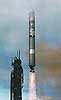 Vandenberg - June 17, 1999 - Launch of NASA's new QuikScat spacecraft, an ocean-observing weather satellite, has been delayed at least 24 hours while engineers troubleshoot a possible telecommunications problem on the Titan II launch vehicle. Vandenberg - June 17, 1999 - Launch of NASA's new QuikScat spacecraft, an ocean-observing weather satellite, has been delayed at least 24 hours while engineers troubleshoot a possible telecommunications problem on the Titan II launch vehicle.The spacecraft will be lofted into space from California's Vandenberg Air Force Base no earlier than Saturday, June 19 at 7:15 p.m. Pacific Daylight Time. A 10-minute launch window closes at 7:25 p.m. PDT. Engineers discovered noisy data from an inertial measurement unit onboard the Titan II launch vehicle during one of the final spacecraft system checkout tests on Tuesday, June 15. The additional time will allow them an opportunity to investigate the cause of the communications interference and replace electrical circuitry or other hardware units if necessary.
QuikScat Ready For El Nino Adventure The Quick Scatterometer, or QuikScat, will provide climatologists, meteorologists and oceanographers with daily, detailed snapshots of ocean winds as they swirl above the world's oceans. The mission will greatly improve weather forecasting. Winds play a major role in every aspect of weather on Earth. They directly affect the turbulent exchanges of heat, moisture and greenhouse gases between Earth's atmosphere and the ocean. To better understand their impact on oceans and improve weather forecasting, the satellite carries a state-of-the-art radar instrument called a scatterometer for a two-year science mission. "Knowledge about which way the wind blows and how hard is it blowing may seem simple, but this kind of information is actually a critical tool in improved weather forecasting, early storm detection and identifying subtle changes in global climate," said Dr. Ghassem Asrar, associate administrator of NASA's Office of Earth Science, Washington, DC. The mission will help Earth scientists determine the location, structure and strength of severe marine storms - hurricanes in the Atlantic, typhoons near Asia and mid-latitude cyclones worldwide - which are among the most destructive of all natural phenomena. The National Oceanic and Atmospheric Administration (NOAA), a chief partner in the QuikScat mission, will use mission data for improved weather forecasting and storm warning, helping forecasters to more accurately determine the paths and intensities of tropical storms and hurricanes. As NASA's next "El Nino watcher," QuikScat will be used to better understand global El Nino and La Nina weather abnormalities. Changes in the winds over the equatorial Pacific Ocean are a key component of the El Nino/La Nina phenomenon. QuikScat will be able to track changes in the trade winds along the equator. Scatterometers operate by transmitting high-frequency microwave pulses to the ocean surface and measuring the "backscattered" or echoed radar pulses bounced back to the satellite. The instrument senses ripples caused by winds near the ocean's surface, from which scientists can compute the winds' speed and direction. The instruments can acquire hundreds of times more observations of surface wind velocity each day than can ships and buoys, and are the only remote-sensing systems able to provide continuous, accurate and high-resolution measurements of both wind speeds and direction regardless of weather conditions. The satellite is the first obtained under NASA's Indefinite Delivery/Indefinite Quantity program for rapid delivery of satellite core systems. The procurement method provides NASA with a faster, better and cheaper method for the purchase of satellite systems through a "catalog," allowing for shorter turnaround time from mission conception to launch. Total mission cost for QuikScat is $93 million. Fifteen times a day, the satellite will beam down collected science data to NASA ground stations, which will relay them to scientists and weather forecasters. SeaWinds will provide ocean wind coverage to an international team of climate specialists, oceanographers and meteorologists interested in discovering the secrets of climate patterns and improving the speed with which emergency preparedness agencies can respond to fast-moving weather fronts, floods, hurricanes, tsunamis and other natural disasters. By combining QuikScat's wind data with information on ocean height from another ocean-observing satellite, the joint NASA- French TOPEX/Poseidon mission, scientists will be able to obtain a more complete, near-real-time look at wind patterns and their effects on ocean waves and currents, said Dr. Timothy Liu, QuikScat project scientist at NASA's Jet Propulsion Laboratory, Pasadena, CA. He added that QuikScat will complement data being collected by other Earth-monitoring satellites such as NASA's currently orbiting Tropical Rain Measurement Mission (TRMM) and Terra, which will be launched later this year. The 870-kilogram (1,910-pound) QuikScat satellite, provided by Ball Aerospace & Technologies Corp., Boulder, CO, with its 200-kilogram (450-pound) radar instrument, called SeaWinds, will be placed in a circular, near-polar orbit with a ground speed of 6.6 kilometers per second (14,750 miles per hour). The satellite will circle Earth every 101 minutes at an altitude of 800 kilometers (500 miles).
QuickSat At SpaceDaily
Earth Observation Reports At SpaceDaily
|
| |||||||||
| The content herein, unless otherwise known to be public domain, are Copyright 1995-2016 - Space Media Network. All websites are published in Australia and are solely subject to Australian law and governed by Fair Use principals for news reporting and research purposes. AFP, UPI and IANS news wire stories are copyright Agence France-Presse, United Press International and Indo-Asia News Service. ESA news reports are copyright European Space Agency. All NASA sourced material is public domain. Additional copyrights may apply in whole or part to other bona fide parties. Advertising does not imply endorsement, agreement or approval of any opinions, statements or information provided by Space Media Network on any Web page published or hosted by Space Media Network. Privacy Statement All images and articles appearing on Space Media Network have been edited or digitally altered in some way. Any requests to remove copyright material will be acted upon in a timely and appropriate manner. Any attempt to extort money from Space Media Network will be ignored and reported to Australian Law Enforcement Agencies as a potential case of financial fraud involving the use of a telephonic carriage device or postal service. |
 Vandenberg - June 13, 1999 - Built in record time in just 12 months, QuikScat, NASA's new ocean-observing satellite, will be launched on a Titan II rocket from California's Vandenberg Air Force Base at 7:15 p.m. Pacific Daylight Time on June 18. This satellite will be NASA's next "El Nino watcher" and will be used to better understand global weather abnormalities.