| . |  |
. |
It's been sailing the blackness of space now for a decade: a silent sentinel, watching over the world's oceans, looking for signs of the mysterious El Nino and La Nina phenomena whose cantankerous dispositions wreak havoc on our weather. TOPEX/Poseidon, a joint NASA-French Space Agency mission to study ocean circulation and its effect on climate, turned 10 on Saturday. Some 46,763 orbits after launch on an Ariane 42P rocket from the Guiana Space Center in Kourou, French Guiana, this spacecraft, designed to fly three to five years, continues to precisely map the surface height of 95 percent of Earth's ice-free oceans every 10 days. In doing so, it has revolutionized the study of Earth's oceans. Best known for its ability to monitor the progress of large-scale ocean phenomena like El Nino, La Nina and a long-term ocean feature called the Pacific Decadal Oscillation that waxes and wanes every 20 to 30 years, this longest-running Earth-orbiting radar mission has amassed some impressive achievements. Its continuous data on sea surface height, wind speed and wave height have given us a new understanding of how ocean circulation affects climate. The satellite provides input for long-term climate forecasting and prediction models. TOPEX/Poseidon produced the first global views of seasonal current changes. It maps year-to-year changes in upper- ocean heat storage. The satellite has improved our understanding of tides, producing the world's most precise global tidal maps and demystifying deep-ocean tides and their effect on ocean circulation. It monitors global mean sea-level changes, an effective indicator of the consequence of global temperature change. Its data are input into atmospheric models for forecasting hurricane seasons and individual storm severity. And the satellite has improved our knowledge of Earth's gravity field. "TOPEX/Poseidon has revolutionized the ocean sciences," said Dr. Lee- Lueng Fu, TOPEX/ Poseidon project scientist at NASA's Jet Propulsion Laboratory (JPL), Pasadena, Calif. "For the first time, the great pulse of the oceans -- ocean eddies, seasonal cycles and year-to-year climate signals -- has been mapped with unprecedented accuracy, yielding fundamentally important information for testing ocean circulation models." "TOPEX/Poseidon data help forecast short-term changes in weather and longer-term climate patterns," said JPL oceanographer Dr. William Patzert. "Ocean currents flow around highs and lows of oceanic pressure, distributing the Sun's heat across the globe and releasing It back into the atmosphere as water vapor, which is returned to the oceans and land as rain or snow. Understanding the oceans' behavior is the key to forecasting climate change." Nearly 400 science users worldwide apply TOPEX/Poseidon's data in a variety of ways. Fishermen use the data, along with sea-surface temperature imagery, to locate fish. Satellite altimetry is used to identify key habitats for other marine animals, which can then be tracked and studied. Maps from TOPEX/Poseidon data help sailors and commercial ships chart their courses. Offshore oil operators and cable- laying vessels use knowledge of ocean circulation patterns to minimize impacts from strong currents. Marine biologists use the data to monitor and assess coral-reef ecosystems sensitive to ocean temperature changes. The mission can even track ocean debris. Jason, TOPEX/Poseidon's follow-on, was launched December 7, 2001, carrying updated versions of the same instruments. That joint U.S.- French mission, which will continue building a long-term database, is currently in a six-month scientific validation phase. TOPEX/Poseidon's longevity has given scientists the opportunity to fly Jason in a parallel orbit, doubling the amount of data now being collected. The tandem mission will enable improved detection of ocean eddies, coastal tides and currents. Planning for TOPEX/Poseidon began in 1979, when NASA started planning the TOPEX mission, while the French Space Agency was planning Poseidon. The two agencies formed a single mission in 1983. JPL manages the U.S. portion of TOPEX/Poseidon and Jason for NASA's Earth Science Enterprise. JPL is a division of the California Institute of Technology in Pasadena. Research on the Earth's oceans using TOPEX/Poseidon and Jason and other space-based capabilities is conducted by NASA's Earth Science Enterprise to better understand and protect our home planet. Related Links More about TOPEX/Poseidon and Jason SpaceDaily Search SpaceDaily Subscribe To SpaceDaily Express  Pasadena - Nov 7, 2001
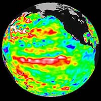
The Pacific ocean continues to be dominated by the Pacific Decadal Oscillation, an above normal sea level pattern that is larger and stronger than any El Nino/La Nina event, according to the latest information from the U.S.-French Topex/Poseidon ocean-monitoring satellite.
|
| ||||||||||
| The content herein, unless otherwise known to be public domain, are Copyright 1995-2016 - Space Media Network. All websites are published in Australia and are solely subject to Australian law and governed by Fair Use principals for news reporting and research purposes. AFP, UPI and IANS news wire stories are copyright Agence France-Presse, United Press International and Indo-Asia News Service. ESA news reports are copyright European Space Agency. All NASA sourced material is public domain. Additional copyrights may apply in whole or part to other bona fide parties. Advertising does not imply endorsement, agreement or approval of any opinions, statements or information provided by Space Media Network on any Web page published or hosted by Space Media Network. Privacy Statement All images and articles appearing on Space Media Network have been edited or digitally altered in some way. Any requests to remove copyright material will be acted upon in a timely and appropriate manner. Any attempt to extort money from Space Media Network will be ignored and reported to Australian Law Enforcement Agencies as a potential case of financial fraud involving the use of a telephonic carriage device or postal service. |