| . |  |
. |
The question of when and how hard the next El Nino or La Nina will hit can now be answered up to nine months ahead of the event, thanks to work by CSIRO's climate scientists. CSIRO has begun estimating long-range probabilities of receiving above or below median rainfall over much of the country, based on forecasts of whether El Nino or La Nina conditions will develop in the Pacific Ocean. "We use sophisticated climate models run on a supercomputer to predict sea surface temperatures in the equatorial Pacific Ocean. These temperatures provide a measure of the strength of El Nino and La Nina," says Dr Ian Smith, from CSIRO Atmospheric Research. "Our predictions build on over a decade's climatic research by CSIRO," says Dr Smith. La Nina conditions prevailed up until late last year and were accompanied by significantly above-average rainfall over much of Australia. In fact, 2000 was classified as the second wettest on record. Since then, La Nina conditions have waned. "Everyone is asking when the next El Nino event will occur," says Dr Smith. Typically, El Nino means drier than normal conditions over much of eastern and northern Australia. The last El Nino was in 1997. CSIRO predicts neutral conditions (neither El Nino or La Nina) through to autumn of 2002. CSIRO will update its predictions monthly. "The predictions are sometimes skilful up to 9 months ahead in time but, at this time of year it is too early to make skilful predictions for winter 2002," says Dr Smith, "but we are closely checking for signs that an El Nino may develop next year". The National Climate Centre, and the Queensland Centre for Climate Applications provide rainfall outlooks three months ahead.
The Commonwealth Government's Climate Variability in Agriculture Research and Development Program helped fund this research. El Nino events occur irregularly every 2 to 7 years. Unusually warm sea surface temperatures in the eastern Pacific Ocean initiate them. Accompanying this temperature change, moist winds that blow across the Pacific towards Australia slacken. As a result, rainfall over much of Australia declines. El Nino's counterpart, La Nina, is often responsible for above average rainfall, especially in the eastern States. La Nina is associated with a warming of the ocean north of New Guinea and a cooling of the surface of the eastern Pacific Ocean. This favours moist winds that often bring us rain. These El Nino and La Nina predictions complement the specialised industry-based predictions recently announced by CSIRO. The CSIRO long-lead predictions are available from www.dar.csiro.au/res/cm/coca.htm Related LinksSpaceDaily Search SpaceDaily Subscribe To SpaceDaily Express  Pasadena - Nov 7, 2001
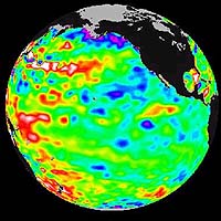
The Pacific ocean continues to be dominated by the Pacific Decadal Oscillation, an above normal sea level pattern that is larger and stronger than any El Nino/La Nina event, according to the latest information from the U.S.-French Topex/Poseidon ocean-monitoring satellite.
|
| |||||||||||
| The content herein, unless otherwise known to be public domain, are Copyright 1995-2016 - Space Media Network. All websites are published in Australia and are solely subject to Australian law and governed by Fair Use principals for news reporting and research purposes. AFP, UPI and IANS news wire stories are copyright Agence France-Presse, United Press International and Indo-Asia News Service. ESA news reports are copyright European Space Agency. All NASA sourced material is public domain. Additional copyrights may apply in whole or part to other bona fide parties. Advertising does not imply endorsement, agreement or approval of any opinions, statements or information provided by Space Media Network on any Web page published or hosted by Space Media Network. Privacy Statement All images and articles appearing on Space Media Network have been edited or digitally altered in some way. Any requests to remove copyright material will be acted upon in a timely and appropriate manner. Any attempt to extort money from Space Media Network will be ignored and reported to Australian Law Enforcement Agencies as a potential case of financial fraud involving the use of a telephonic carriage device or postal service. |