| . |  |
. |
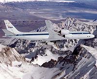
Sydney - August 17, 2000 - A major airborne scientific mission using state-of-the-art equipment to map landforms and vegetation in large areas of Australia is about to be carried out by CSIRO and UNSW in conjunction with NASA. The mission will provide vital information for environmental management and geological mapping. The PACRIM 2000 mission will use NASA's DC-8 airborne research laboratory, flying at altitudes of up to 8000 metres, to chart and assess previously unknown information about our continent. The highly modified aircraft carries a suite of precision instruments that can see through clouds and in some cases detect features beneath sand and vegetation. UNSW's Professor Tony Milne, co-chairman of PACRIM 2000, said the Australian mapping, commencing in Adelaide today is part of an unprecedented earth-mapping mission in the Pacific Rim region. "The data collected will enable scientists to map environmental resources in the Pacific and Asia region, some for the first time. Information collected by this mission will contribute to improved environmental protection techniques and increased awareness of regional problems, particularly those associated with climate change and possible sea level fluctuations," he said. Professor Milne, in collaboration with the Australian Greenhouse Office, will be using some PACRIM-collected data to try to find a way to predict the amount of carbon stored in forests and woodlands and the amount which would be released into greenhouse gases by the cutting down of trees. Dr Ian Tapley, a CSIRO scientist with the Landscape Evolution and Mineral Exploration CRC and coordinator of the scientific program for the mission, will use the data collected to identify sites of saline-groundwater seepage - areas associated with the development of acid-sulphate soils - in the Adelaide hills. "Acid-sulphate soils are a growing environmental problem," said Dr Tapley. "Precise maps of affected areas are needed to help develop management strategies to minimise land degradation and to improve farm production and local water quality." The PACRIM 2000 mission uses a sophisticated radar system known as AIRSAR to collect data describing the texture of earth's surface and sub-surface features. AIRSAR is a side-looking radar that operates simultaneously at three wavelengths. It can also be used to produce very accurate digital elevation models and topographic maps as well as detect ocean current movements In the Australian section of the mission, which will take four weeks, the plane will fly over all States and investigate 55 sites. The data collected will range from topographic mapping of Macquarie island, 1000km south of Tasmania, to monitoring mangrove species in Cairns and Kakadu. The data collected will be processed at NASA's Jet Propulsion Laboratory in California before being handed over to the 25 Australian institutions, including CSIRO, universities and government departments, involved in PACRIM 2000. "Because radar can be operated day or night and can see through clouds, it's possible to gather information in regions such as the tropics where weather may preclude the use of optical remote sensing," Professor Milne said. Other areas to be mapped during PACRIM 2000 include Cambodia's Angkor Wat Temple, a World Heritage wetland site in Malaysia, native timber forests in Indonesia, French Polynesia, Papua New Guinea, the Philippines, Singapore and Vietnam.
TERRADAILY.COM
|
| ||||||||||
| The content herein, unless otherwise known to be public domain, are Copyright 1995-2016 - Space Media Network. All websites are published in Australia and are solely subject to Australian law and governed by Fair Use principals for news reporting and research purposes. AFP, UPI and IANS news wire stories are copyright Agence France-Presse, United Press International and Indo-Asia News Service. ESA news reports are copyright European Space Agency. All NASA sourced material is public domain. Additional copyrights may apply in whole or part to other bona fide parties. Advertising does not imply endorsement, agreement or approval of any opinions, statements or information provided by Space Media Network on any Web page published or hosted by Space Media Network. Privacy Statement All images and articles appearing on Space Media Network have been edited or digitally altered in some way. Any requests to remove copyright material will be acted upon in a timely and appropriate manner. Any attempt to extort money from Space Media Network will be ignored and reported to Australian Law Enforcement Agencies as a potential case of financial fraud involving the use of a telephonic carriage device or postal service. |