| . |  |
. |
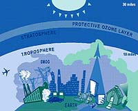
During summertime ozone near the Earth's surface forms in most major U.S. cities when sunlight and heat mix with car exhaust and other pollution, causing health officials to issue "ozone alerts." But in other parts of the world, such as the tropical Atlantic, this low level ozone appears to originate naturally in ways that have left scientists puzzled. Now, NASA-funded scientists using four satellites can tell where low level ozone pollution comes from and whether it was manmade or natural. Atmospheric scientist David Edwards and his colleagues from the National Center for Atmospheric Research (NCAR) and collaborators in Canada and Europe have studied this problem using satellite data from three NASA spacecraft, one from the European Space Agency (ESA), and a computer model from NCAR. They were surprised to find that a greater amount of near-surface ozone over the tropical Atlantic develops as a result of lightning instead of agricultural and fossil fuel burning. Their findings appeared in a recent issue of the American Geophysical Union's Journal of Geophysical Research Atmospheres. The formation of ozone involves several factors, such as lightning and pollution from agricultural and fossil fuel burning, which is why it was helpful to use NASA's multiple satellites to look at each in turn. NASA satellites included Terra, the Tropical Rainfall Measuring Mission (TRMM), and Earth Probe/TOMS. ESA's ERS-2 satellite was also used to look at ozone, and NCAR's MOZART-2 (Model for OZone And Related chemical Tracers) computer model was used to simulate the chemical composition of the atmosphere. Because the different satellite instruments could detect fires, lightning flashes, and the resulting pollution and ozone in the atmosphere, respectively, they provided a bird's-eye global view of what was going on, and the computer model helped tie all the pieces together. Fires create smoke and carbon monoxide, and lightning creates nitrogen oxides (NOx). All of these come together with other unstable compounds in a chemical soup, and sunlight helps trigger the reaction that helps form ozone. The scientists found that in the early part of the year, the intense fires set by farmers for land-clearing and traditional cultivation in north-western Africa, just south of the Sahara Desert, resulted in large amounts of pollution that they could track using satellite images as it spread over the Atlantic towards South America. This pollution greatly increased ozone at low altitudes near the fires. However, when Edwards and his colleagues looked at areas of elevated ozone levels measured by satellites and aircraft over the Atlantic south of the equator, they were more surprised to find that this ozone was caused mainly by lightning rather than the fires. In other parts of the world, especially near cities, ozone near Earth's surface is often made from pollution as a result of industrial fossil-fuel burning and cars. Understanding where the pollution comes from in each case is important for improving our air quality. NASA's Measurements of Pollution in the Troposphere (MOPITT) instrument aboard the Terra satellite is a joint NASA/Canadian Space Agency mission that measured carbon monoxide concentrations at various levels of the atmosphere. The TOMS instrument on EP/TOMS measured tropical tropospheric ozone over the mid-Atlantic. The TRMM satellite counted the number of fires in a region using its Visible/Infrared Scanner (VIRS), and also catalogued lightning flash data from its Lightning Imaging Sensor (LIS). The satellite data was then interpreted using the MOZART-2 computer model. Previously, scientists used TOMS observations to get a general idea of where the tropospheric ozone levels were high, but it was often difficult to say where the ozone came from and which pollution source or natural process led to its creation. Only recently has the 4 satellite combination enabled scientists to make this distinction. Related Links Terra Satellite TRMM Satellite TOMS Satellite MOPITT http://www.epa.gov/oar/oaqps/gooduphigh/#goodbad GOME SpaceDaily Search SpaceDaily Subscribe To SpaceDaily Express  Saint-Hubert - May 26, 2003
The Canadian Space Agency today announced that the OSIRIS instrument (Optical Spectrograph and InfraRed Imager System), flying onboard Swedish satellite Odin, will keep providing detailed data relating to ozone depletion for one more year, as the satellite and instruments, including an advanced radiometer for microwave radiation, are still functional after having completed their 2 year initial mission.
|
| ||||||||||
| The content herein, unless otherwise known to be public domain, are Copyright 1995-2016 - Space Media Network. All websites are published in Australia and are solely subject to Australian law and governed by Fair Use principals for news reporting and research purposes. AFP, UPI and IANS news wire stories are copyright Agence France-Presse, United Press International and Indo-Asia News Service. ESA news reports are copyright European Space Agency. All NASA sourced material is public domain. Additional copyrights may apply in whole or part to other bona fide parties. Advertising does not imply endorsement, agreement or approval of any opinions, statements or information provided by Space Media Network on any Web page published or hosted by Space Media Network. Privacy Statement All images and articles appearing on Space Media Network have been edited or digitally altered in some way. Any requests to remove copyright material will be acted upon in a timely and appropriate manner. Any attempt to extort money from Space Media Network will be ignored and reported to Australian Law Enforcement Agencies as a potential case of financial fraud involving the use of a telephonic carriage device or postal service. |