| . |  |
. |
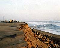
San Francisco CA (SPX) Dec 14, 2004 Engineers who were studying beach erosion got more than they bargained for recently when they discovered unexpected wave behavior in the water along an east coast shoreline. The finding could ultimately cause researchers to re-examine ideas about beach erosion and the repair of beaches that are damaged by tropical storms. "It could just be that the physics of the system is a little different than we thought," said Thomas Lippmann, a research scientist in the Department of Civil and Environmental Engineering and a researcher with the Byrd Polar Research Center at Ohio State University. When the Ohio State researchers utilized data collected by collaborators at Duck, NC, to calibrate a new remote sensing method for studying ocean currents, they expected to find some complex wave flow patterns in the water. Researchers have long known that the surf contains many different currents that interact to affect how sand washes away from a beach. That's why mitigating beach erosion is so difficult, Lippmann said. But their close examination of the oscillating water flow at different depths revealed a surprisingly intricate system of patterns, with surface currents not always in sync with the bottom flow. As Lippmann reported his team's early results Monday at the meeting of the American Geophysical Union in San Francisco, he declined to speculate on what causes the strange flow patterns. For instance, they found regions where the water near the surface was rotating in one direction -- say, clockwise - and the water just a meter or two below it was rotating counterclockwise. Taken together, the unusual patterns make for a more complicated picture of water movement than most researchers suspected, Lippmann said. Scientists may have to take the new findings into account when they design computer models of beach erosion, nearshore circulation, or water quality. These topics are of particular interest to coastal towns, where erosion causes millions of dollars in property losses each year. Constant erosion, compounded by sudden beach loss during tropical storms, threatens the multibillion-dollar tourist industry. Coastal residents have tried to counter erosion by adding sand to beaches or building artificial seawalls out of wood or rocks, but some studies have shown that these efforts do not provide a permanent solution - and may actually increase erosion in certain situations. Researchers need to better understand how erosion works in order to develop better mitigation strategies, Lippmann said. That's why researchers from many different institutions have planted special underwater sensors along the beach in Duck, NC. Although the sensors take very accurate measurements of water movement just above the sand, they are very expensive and require expert installation. Lippmann and his colleagues recently came up with a less expensive method: a video camera system that tracks the foam from breaking waves. Once the system is fully developed, it could monitor wave motion for a fraction of the cost. The engineers discovered the strange water flow patterns while they were attempting to verify measurements obtained from the camera system. Back in 2000, their video-based measurements, which they then took from towers along the coastline at Duck, compared favorably with data from the in-water sensors. Because their measurements didn't precisely match up - they found differences as large as 20 percent - Lippmann wondered if the discrepancy wasn't due to the fact that the camera system was looking at the surface of the water, while the sensors were measuring currents down at the seafloor. To examine whether flows within the water column were affecting the results, Lippmann and colleagues from the Naval Postgraduate School re-examined some unique data that was collected at the US Army Corps of Engineer's Field Research Facility in Duck in 1994. That experiment involved vertical arrays of sensors that measured water movement at different depths. That data confirmed that the water on the sea floor was moving slower - and, sometimes, even in the opposite direction - compared to water on the surface. So it turned out that the video system was getting accurate measurements after all. "We were feeling pretty good about that," Lippmann said, "Then we noticed that there was a lot more going on in the water column than we first realized." If the engineers hadn't been trying to calibrate the camera system, they may not have looked so closely at the oscillatory flow patterns, and may not have observed the strange behavior. Now, Lippmann said, researchers may have to re-evaluate how they study motions along the shoreline. Related Links Byrd Polar Research Center SpaceDaily Search SpaceDaily Subscribe To SpaceDaily Express  Honolulu HI (SPX) Oct 18, 2004
The newly commissioned National Oceanic and Atmospheric Administration research vessel Hi'ialakai has completed its first mission with a successful, comprehensive, five-week survey of marine ecosystems in the waters of the remote Northwestern Hawaiian Islands Coral Reef Ecosystem Reserve (NWHICRER). NOAA is an agency of the U.S. Department of Commerce.
|
| ||||||||||
| The content herein, unless otherwise known to be public domain, are Copyright 1995-2016 - Space Media Network. All websites are published in Australia and are solely subject to Australian law and governed by Fair Use principals for news reporting and research purposes. AFP, UPI and IANS news wire stories are copyright Agence France-Presse, United Press International and Indo-Asia News Service. ESA news reports are copyright European Space Agency. All NASA sourced material is public domain. Additional copyrights may apply in whole or part to other bona fide parties. Advertising does not imply endorsement, agreement or approval of any opinions, statements or information provided by Space Media Network on any Web page published or hosted by Space Media Network. Privacy Statement All images and articles appearing on Space Media Network have been edited or digitally altered in some way. Any requests to remove copyright material will be acted upon in a timely and appropriate manner. Any attempt to extort money from Space Media Network will be ignored and reported to Australian Law Enforcement Agencies as a potential case of financial fraud involving the use of a telephonic carriage device or postal service. |