| . |  |
. |
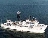
A new NOAA ship will go boldly on a mission to further explore the world's oceans. "We want NOAA's newly converted ship to become the international symbol vessel for ocean exploration and research," said Stephen Hammond, acting director of the NOAA Office of Ocean Exploration. "When it sails to unknown areas of the ocean, chances are excellent that multidisciplinary, international teams of scientist-explorers on board, and on shore at satellite-linked Science Command Centers, will make very fundamental discoveries." Hammond chairs a group on a fast track to plan and develop specifications for a major conversion of the former Navy ship USNS Capable. Following the award of a conversion contract and an estimated 12 to 18 months in a shipyard, the ship will be unique to NOAA and the federal fleet as the only U.S. government ship dedicated to exploring Earth's oceans. "If we plan well now, those scientists will be equipped for success," said Hammond "It will be a path finding ship for discovery and for mapping a route to ocean research." "We are excited about the possibilities this ship offers," said Rick Rosen, NOAA assistant administrator of NOAA Research. "While research largely involves the testing of hypotheses, scientists on this ship will do that and more-they'll be testing, but also generating, hypotheses." After conversion, the 224-foot former Navy ship will be NOAA's only ship with a dedicated science-class deep-ocean robot, or remotely-operated vehicle. The ship will carry 10,000 meters of umbilical cable, weighing more than 22,000 pounds. Up to 6,000 meters will be used to lower a tow sled close to the ocean floor. Another 30 meters of separate cable will connect the tow sled with a mobile ROV equipped with a robust sampling capability. The long umbilical from the ship to tow sled will funnel commands to and collect data and images from the ROV. And, it will provide both the tow sled and ROV with enough electrical power to operate bright lights, high-definition video cameras and high-resolution still cameras. "With the tow sled and ROV both equipped with lights and cameras, we can illuminate and image the ocean to an impressive degree," said Hammond. "And with cameras on the tow sled imaging the ROV, we gain perspective when both the ROV and what it is investigating on the ocean floor are captured in the same image." NOAA's ship for ocean exploration will also be equipped with a hull-mounted, state-of-the-art multibeam mapping sonar system as well as other sampling and surveying instrument systems, and the ship will offer scientists an ROV control center, a mapping lab, a technology center to process scientific data and standard wet and dry labs. "It's a considerable challenge to plan for a ship conversion of this scope," said John McDonough, co-chair of the Working Requirements Group and operations officer in the NOAA Office of Ocean Exploration. "But I am confident because of the highly experienced and knowledgeable NOAA commissioned officers who are at the heart of the conversion planning group. In addition to having representatives from many different NOAA program offices, we're fortunate to have the input of experts from other public and private institutions in areas such as ocean mapping, remotely-operated vehicles and real-time satellite communications." Scientists who miss the ship need not stand on the pier and watch opportunity sail away. They will be ashore at special Science Command Centers, one of which will be built out in NOAA's Silver Spring complex. Though far from a rolling ship, those scientists will be members of the science team-full participants in the ocean expedition. Through high-speed Internet 2 connections, scientists will exchange data and see deep-ocean images and specimens taken by ROVs at the same time as their counterparts on the ship, or at other Science Command Centers ashore. Because it's vitally important that the ship maintains position while operating ROVs, the ship will be equipped with a dynamic positioning system, or "DP," linking ship instruments measuring wind, speed and currents, with a Global Positioning System (GPS) reading from satellite. The system then automatically adjusts the ship's main and thruster engines to keep the ship in a very tight circle, no more than 10 meters off target. "You need your ROV to stay on station to do its job, either for conducting general reconnaissance within a given target area or for following gridlines for a detailed assessment of habitat or artifacts," said McDonough. "That requires precise positioning. You also need DP to keep from dragging your ROV across an obstruction on the ocean floor." A big part of converting the ship will be mounting a multibeam mapping sonar on the bottom of the hull. McDonough and others visited the NOAA ship Hi'ialakai in a Portland shipyard because that ship is the same T-AGOS class as the former Navy ship Capable, and because Hi'ialakai is having a similar multibeam mapping system installed. The crew working on the installation of the system on Hi'ialakai provided valuable information about the installation process. Previous ocean explorations have discovered and filmed a volcano erupting underwater and have mapped underwater canyons, seamounts and deep-sea corals. Scientists on ocean explorations have discovered numerous new species, researched historic shipwrecks and other submerged cultural resources and found compounds in marine animals that produce medicines from the sea. "The ocean is so little understood that a good part of the ship's mission will be to just find out what's there," Hammond said. "With 71 percent of the Earth covered by ocean, 'what's out there' is immense, and with 95 percent of that unexplored, unseen by human eyes, we have rich opportunities for exploration and research." The former Navy ship Capable will be renamed soon when NOAA selects a winning ship name from those submitted by teams of students challenged in a nationwide contest to name NOAA's ship and to create a supporting science project. NOAA is dedicated to enhancing economic security and national safety through the prediction and research of weather and climate-related events and providing environmental stewardship of the nation's coastal and marine resources. NOAA is part of the U.S. Department of Commerce. Related Links NOAA Office of Ocean Exploration NOAA Ocean Service SpaceDaily Search SpaceDaily Subscribe To SpaceDaily Express 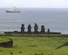 Paris (ESA) Dec 28, 2004
There is a desert in the heart of the South Pacific. Surrounding Easter Island is the purest and bluest seawater on Earth, almost empty of the microscopic phytoplankton at the base of the marine food web. French vessel L'Atalante recently completed a research cruise through this region, its day-to-day route guided by ocean colour satellites.
|
| ||||||||||
| The content herein, unless otherwise known to be public domain, are Copyright 1995-2016 - Space Media Network. All websites are published in Australia and are solely subject to Australian law and governed by Fair Use principals for news reporting and research purposes. AFP, UPI and IANS news wire stories are copyright Agence France-Presse, United Press International and Indo-Asia News Service. ESA news reports are copyright European Space Agency. All NASA sourced material is public domain. Additional copyrights may apply in whole or part to other bona fide parties. Advertising does not imply endorsement, agreement or approval of any opinions, statements or information provided by Space Media Network on any Web page published or hosted by Space Media Network. Privacy Statement All images and articles appearing on Space Media Network have been edited or digitally altered in some way. Any requests to remove copyright material will be acted upon in a timely and appropriate manner. Any attempt to extort money from Space Media Network will be ignored and reported to Australian Law Enforcement Agencies as a potential case of financial fraud involving the use of a telephonic carriage device or postal service. |