| . |  |
. |
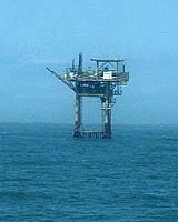
Imagine a place where the roads change constantly and last month's map may be completely out of date. That's the ocean. Knowing where the currents were a week ago won't help a ship captain chart the best course or a clean-up crew anticipate where an oil spill is heading nearly as much as knowing where the currents are today. Take Captain Karl Greig, for example, who skippers a large anchor-handling towing supply boat in the Gulf of Mexico. He works for Edison Chouest Offshore moving oil rigs from one spot to another as they search for oil and natural gas. Each rig comes with eight to 12 anchors along with heavy chain and steel cables. Top towing speed is two to four knots, about as fast as strong ocean currents. Greig needs up-to-the minute information on ocean currents and now he can get it, thanks to near real-time ocean altimetry. Greig now regularly taps into the Web site of the University of Colorado's Center for Astrodynamics Research, where the latest satellite measurements of sea surface height are used to create maps showing the location, direction and speed of currents in the Gulf of Mexico. Greig calculated that this information helped him shorten his towing time on one 724-kilometer (425-mile) tow trip last year by more than 50 hours. "I was able to adjust my course to avoid towing into the Loop Currents and to get one astern of us and increase our tow speed by almost two knots," says Greig. "That saved the company chartering the equipment a considerable amount of money." Currents follow the ocean's ever-changing landscape. The best way to map global ocean currents is from space with altimetry, measurements of sea surface topography. NASA satellites have been making continuous measurements of ocean altimetry since 1992 beginning with the launch of Topex/Poseiden followed by Jason. Now four different international satellites orbit Earth making continuous measurements of sea surface height. The data are available to the public free of charge. Scientists were quick to use altimetry data for studies ranging from long-term climate change to predicting the next El Ni�o. For most researchers, the month it took for satellite data to be downloaded, processed and delivered wasn't a problem. However, with the advent of near real-time altimetry data just a few years ago and Web sites that offer help in how to use it, a whole new group of people, such as Captain Greig, are taking advantage of this new information both for work and for pleasure. Near real-time altimetry, as global positioning has already done, is working its way from the military and scientific spheres into everyday life. "I couldn't do my job without it," says oceanographer Jenifer Clark, "I use it all over the world for yacht races." Clark, who half jokingly calls herself "the AAA of the ocean," runs her own company preparing real-time ocean charts for sailboat racing, ocean cruising, fisheries and other uses. She uses a variety of sources, including buoys and satellite sea surface temperature measurements and altimetry, to create her charts. Near real-time altimetry data also helped Spanish authorities deal with the massive oil spill caused when the oil tanker Prestige broke apart and sank in November 2002. Within hours of the ship's sinking, the U.S. Navy's research laboratory began providing current information for those in charge of clean up. The laboratory now produces a daily 72-hour forecast of ocean currents for the area based on computer models that assimilate different types of satellite data, including sea-surface temperature measurements and ocean altimetry. "It is critical to have near real-time observations," says Greg Jacobs, head of the Ocean Dynamics and Prediction Branch of the Naval Research Laboratory Stennis Space Center. "You have the same problems predicting ocean currents as predicting the weather. It's the 'butterfly effect' -- over time, a small change in one place can grow through time to completely alter the flow in another area," explains Jacobs. "If we didn't have constant observations, we wouldn't have any idea about what the currents or the weather would be like a week from now." The Naval Research Laboratory's public Web site has a wide range of users, including fishermen, sailors and oil companies, according to Jacobs. Sources of near real-time ocean altimetry are growing along with the number of users. However, being able to use satellite data does require skill. "The learning curve is pretty steep," says Robert Leben, associate research professor at the University of Colorado's Center for Astrodynamics Research. "The ocean is a complicated fluid system." Many altimetry data users, especially industry, turn to consultants to help them translate the data into the specific information they need, he says. But, he adds, learning to read satellite maps of ocean currents is not unlike learning to understand a weather map. "If you work at it, you can figure out how to get the information you're looking for," Leben says, "and there are a lot of resources on the Web to help." Related Links SpaceDaily Search SpaceDaily Subscribe To SpaceDaily Express 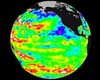 Raleigh - Mar 01, 2004
Since 1776, when naval mines were invented, navies have rightfully feared the stealthy and relatively simple weapons, which can disable or destroy warships and paralyze vital shipping. Navies worldwide employ a host of mine-detection technologies and techniques, most of them complicated, expensive, and far from perfect. So a simpler, more effective method for detecting these mines, developed by a physicist at North Carolina State University, could make big waves in naval headquarters around the globe.
|
| ||||||||||
| The content herein, unless otherwise known to be public domain, are Copyright 1995-2016 - Space Media Network. All websites are published in Australia and are solely subject to Australian law and governed by Fair Use principals for news reporting and research purposes. AFP, UPI and IANS news wire stories are copyright Agence France-Presse, United Press International and Indo-Asia News Service. ESA news reports are copyright European Space Agency. All NASA sourced material is public domain. Additional copyrights may apply in whole or part to other bona fide parties. Advertising does not imply endorsement, agreement or approval of any opinions, statements or information provided by Space Media Network on any Web page published or hosted by Space Media Network. Privacy Statement All images and articles appearing on Space Media Network have been edited or digitally altered in some way. Any requests to remove copyright material will be acted upon in a timely and appropriate manner. Any attempt to extort money from Space Media Network will be ignored and reported to Australian Law Enforcement Agencies as a potential case of financial fraud involving the use of a telephonic carriage device or postal service. |