| . |  |
. |
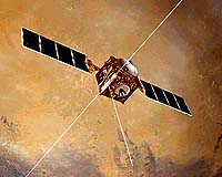
Pasadena CA (JPL) Mar 01, 2005 The first week of May, the Mars Express spacecraft will unfurl its radar antenna. The Mars Advanced Radar for Subsurface and Ionosphere Sounding - or MARSIS - will have many tasks, but one of the most important will be the search for liquid water. The radar will peer down into the soil itself, looking deep below the surface, in effect peeling back the layers of Mars without the effort of digging or drilling. At the recent European Space Agency Mars Express conference in Noordwijk, Netherlands, Astrobiology Magazine editor Leslie Mullen talked with Jeffrey Plaut of the Jet Propulsion Laboratory, Co-Principal Investigator for the MARSIS instrument. Astrobiology Magazine (AM): Mars Express has been in orbit for over a year. Why is the MARSIS instrument only now being deployed? Jeffrey Plaut (JP): After we were in orbit around Mars, the manufacturer of the antenna did some additional modeling of the deployment process. It's an uncontrolled process, because a door opens - sort of like a Jack-in-the-Box - and then the antenna, which is folded back on itself, springs out. Once we got to Mars, the new model indicated that when one of the booms went out, it could snap back and contact the spacecraft. If that happened, it could damage some component or get snagged on the spacecraft, which could affect the spacecraft dynamics. Since then, more modeling has been done in much greater detail by the spacecraft team, both at ESA and with the industry spacecraft builder. They've identified all of the vulnerable pieces on the spacecraft, and they don't feel it's a very dangerous operation. There's still some risk, but it's a risk we've agreed to live with. AM: The MARSIS radar is going to look for the electrical contrasts caused by boundary conditions - in other words, the transition from one sort of geologic material to another. Could you describe the science behind that, and what you expect to find? JP: When we talk about electrical properties, we mean something called the dielectric constant. Basically when a radar wave encounters a boundary, as it travels from one medium into another medium, some of the energy gets reflected and some of the energy gets transmitted. We're looking for the part that gets reflected. The geologic boundary might be just two different types of rock, or soil that sits on top of rock, or it might be rock that contains ice, and below that, rock that contains liquid water. Each kind of geologic material has a certain reflectivity value, equivalent to this dielectric constant. Liquid water has the highest value of any material that we expect to find on Mars. AM: So liquid water would have a different value than water ice? JP: Yes. Liquid water is much, much more reflective than ice. Ice is actually intermediate in its reflectivity between soil and solid rock. So it may be difficult in some cases for us to detect interfaces where ice is present and ice is absent. But until we start doing the experiment we won't really know how hard that is. AM: Each radar "footprint" will be 10 kilometers across. But as you scan the surface, you're also investigating layers below the surface. Could you describe how that works? JP: With each orbit, we are basically building up a cross-section. As we put together each of our observations, one next to another, it'll be as if you've taken a vertical slice through the terrain. We'll be scanning the whole depth with every observation, from the surface potentially down to about 5 kilometers. The strongest reflection will be off the surface, because there you're going from the atmosphere to some kind of solid, rocky material, and that's a very strong contrast in electrical properties. We typically lose 80 or 90 percent of our energy on that reflection, and it shows up as a very strong peak. In fact, echoes from the next 100 or so meters down in the subsurface will be difficult to separate from that strong surface echo. But once the wave penetrates beyond that first 100 meters and encounters other boundaries, we'll have a better chance of isolating those echoes. AM: From April to August, Mars Express will experience a "night side" phase. Could you explain why that matters for MARSIS? Also, why is Mars Express having a "night side" phase, since Mars rotates and there is no "dark side" of Mars? JP: MARSIS works better on the night side of Mars because the ionosphere - the electrically charged part of the upper atmosphere - is reflective to radio waves in the frequencies that we're using. On the sunny side of Mars, where the solar wind is interacting with the atmosphere, the ionosphere is much more active and it reflects the lower frequency signals. On the night side, where the ionosphere sort of dies down, not nearly so much of the radio energy is reflected, and we can use the low frequency waves that give us our best depth penetration in the subsurface. The reason that there's a night side and a day side for Mars Express is that the spacecraft is in a highly elliptical orbit, and it only visits the planet three times a day. As the mission evolves, the position of the close approach drifts from the day side into the night side. So coming up in the middle of this year, we have an extended period when we will be on the night side. Most of the other instruments on Mars Express like to take their observations in the sun. So it works out nicely for us during these phases when we go to the night side, because we don't compete against these other instruments, and we get a higher priority in the observation queue. AM: So ultimately, will MARSIS give us a global map of the liquid water aquifers on Mars? JP: We don't know if Mars has aquifers presently. If they are there, they may be so deep - deeper than about 5 kilometers - that we can't see them. Or the crust of Mars may not cooperate with our signal, so even if aquifers do exist at shallower levels we may not be able to detect them. However, if we do detect them, and we can unambiguously identify a region as hosting liquid water in the first few kilometers in the crust, then that has huge implications for the current state of water, and certainly for biological possibilities. AM: The temperatures on Mars being so cold, could you have liquid water at shallow depths in the crust? JP: During the summer, on certain days in certain locations, the surface temperature might reach 0 degrees C - the melting point of water. But that warm surface doesn't communicate with the subsurface a kilometer down; the daily or seasonal thermal wave doesn't penetrate more than a few meters. Once you get down to tens or hundreds of meters or more, there is a longer term, climatic average temperature that is far below the melting point of water. But as you go deeper into any planet, things get warmer because the interior of planets provide a source of heat, mainly from the decay of radioactive elements. It's that change in temperature with depth, which on Earth we call the geothermal gradient, that determines how deep you have to go on Mars before it is warm enough to melt ice. There are models that tell us how deep that is - it could be anywhere from a few kilometers to over 10 kilometers. AM: So MARSIS is a way to test that. JP: It is a way to test it, but you also need to have the water molecules there, in that part of the crust. Right now, we only know that water exists as ice at the poles, in the shallow subsurface in the polar regions, and in the atmosphere. It's still a mystery whether there's a significant amount of water deep in the crust of Mars. Related Links MARSIS Science Page SpaceDaily Search SpaceDaily Subscribe To SpaceDaily Express  Paris (ESA) Feb 28, 2005
These images, taken by the High Resolution Stereo Camera (HRSC) on board ESA's Mars Express spacecraft, were released at the First Mars Express Science Conference this week. They show the areas of focused research - water, ice, glaciers and volcanism.
|
| ||||||||||
| The content herein, unless otherwise known to be public domain, are Copyright 1995-2016 - Space Media Network. All websites are published in Australia and are solely subject to Australian law and governed by Fair Use principals for news reporting and research purposes. AFP, UPI and IANS news wire stories are copyright Agence France-Presse, United Press International and Indo-Asia News Service. ESA news reports are copyright European Space Agency. All NASA sourced material is public domain. Additional copyrights may apply in whole or part to other bona fide parties. Advertising does not imply endorsement, agreement or approval of any opinions, statements or information provided by Space Media Network on any Web page published or hosted by Space Media Network. Privacy Statement All images and articles appearing on Space Media Network have been edited or digitally altered in some way. Any requests to remove copyright material will be acted upon in a timely and appropriate manner. Any attempt to extort money from Space Media Network will be ignored and reported to Australian Law Enforcement Agencies as a potential case of financial fraud involving the use of a telephonic carriage device or postal service. |