| . |  |
. |
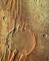
These images were taken by the High Resolution Stereo Camera (HRSC) on board ESA's Mars Express of the Acheron Fossae region, an area of intensive tectonic (continental 'plate') activity in the past. The images show traces of enormous stress and corresponding strain in the crust of the Red Planet. The HRSC was pointed twice at this interesting geological feature in the Acheron Fossae mountain range, during orbits 37 and 143. The feature is situated at approximately 35-40 deg North and 220-230 deg East, about 1000 kilometres north of the large Olympus Mons volcano. For practical use on the internet, the images have been reduced in their resolution -- the data originally obtained from orbit at an altitude of 765 kilometres (orbit 37) and 1240 kilometres (orbit 143) have a resolution of 30 metres and 50 metres per pixel respectively. The images in colour, high-resolution and 3D show spectacular curved depressions that have opened the surface, up to 1700 metres deep, through faulting in the Acheron mountain ranges. In Greek mythology, Acheron is the river entering the underworld, the Hades, and 'fossa' is the Latin word for trough. Acheron Fossae marks the northern edge of the Tharsis plateau. It is part of a network of extensional fractures that radiates outward from their central focus in the Tharsis 'bulge', a huge area of regional uplift where intensive volcanic activity occurred. These curved 'faults' were caused in the process of this uplift: cracks in the crust formed when the hot material rising from deep in the mantle of Mars pushed the overlying 'elastic' lithosphere (surface layers of rock) upward. When the distorting tensions became too strong, the brittle crust on top of the lithosphere broke along zones of weakness. Images 1-3, from orbit 37, are dominated by these curved features, showing a highly fractured, faulted and deformed area in the central part of the Acheron Fossae. In geological terms, this is called a 'horst and graben' system. When several parallel faults form, the block of crust between them drops down, forming a 'graben'. At Acheron, an almost classical example of parallel fault-bounded grabens has formed, dissected by remnants of the pre-existing topographical heights, the 'horsts'. Images 4-6, with the large crater, 55 kilometres in diameter, were taken about 250 kilometres west of images 1-3. They show how the rifting crosses the older impact crater with at least three alternating horsts and grabens. The Acheron Fossae region can be compared to rift zones on Earth, where continental plates spread apart, as is known from the Kenyan Rift Valley in eastern Africa. The 3D capability of the HRSC instrument allows geologists to investigate in great detail these tectonic structures on Mars that could be similar to continental rifts on Earth. From the edge of a horst in Acheron Fossae to the bottom of a graben, the digital elevation data from the HRSC reveal height differences of more than 1700 metres. The large graben in the centre of the image is about 15 kilometres wide. By viewing the 3D (anaglyph) images through stereoscopic glasses, you can see the different topographic levels from which material has been removed and then flowed to lower levels of terrain. Lobe-shaped features are indicative of viscous flow. Erosional processes later transported material from the outside the area into the crater and resurfaced its floor, erasing the tectonic features inside the crater. The depth of the crater from rim to bottom is 2000 metres. The colour and black and white images show the view looking straight down from the spacecraft; north is to the right. The perspective view shows the same region including some adjacent areas to the south without vertical exaggeration. The 3D images require stereoscopic glasses to view. Related Links Mars Express at ESA SpaceDaily Search SpaceDaily Subscribe To SpaceDaily Express  Paris (ESA) Apr 30, 2004
The MARSIS team has advised ESA to delay the deployment of the MARSIS radar instrument on board Mars Express, scheduled for this week.
|
| ||||||||||
| The content herein, unless otherwise known to be public domain, are Copyright 1995-2016 - Space Media Network. All websites are published in Australia and are solely subject to Australian law and governed by Fair Use principals for news reporting and research purposes. AFP, UPI and IANS news wire stories are copyright Agence France-Presse, United Press International and Indo-Asia News Service. ESA news reports are copyright European Space Agency. All NASA sourced material is public domain. Additional copyrights may apply in whole or part to other bona fide parties. Advertising does not imply endorsement, agreement or approval of any opinions, statements or information provided by Space Media Network on any Web page published or hosted by Space Media Network. Privacy Statement All images and articles appearing on Space Media Network have been edited or digitally altered in some way. Any requests to remove copyright material will be acted upon in a timely and appropriate manner. Any attempt to extort money from Space Media Network will be ignored and reported to Australian Law Enforcement Agencies as a potential case of financial fraud involving the use of a telephonic carriage device or postal service. |