| . |  |
. |
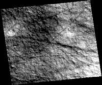
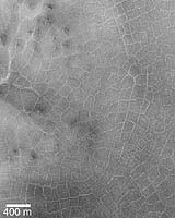
Los Angeles (SPX) Mar 03, 2005 In 1999 I sent SpaceDaily, and other media, information from a 1998 informal study I did of some Mars Global Surveyor images of the northern hemisphere of Mars. The first image I found was suggestive of an icy cracked terrain similar in appearance to images returned of the surface of Europa. I showed the raw image to a few geologists who said the image just showed a lot of dust devil activity. Sure there were dust devils there, but the terrain definitely showed deep shadows from the cracks. If the cracks were indicative of water ice, this would mean there is an enormous resource for life on Mars as well as a source of water for any future human missions to Mars. Not wanting to just dismiss the cracks and crevices as merely dust devil activity I asked circadian astrobiologist Dr. Joseph Miller of the University of Southern California to do some computer enhancements for me from this same latitude. His image (pictured) dramatically shows the extended relief of the topography. Miller's enhanced image show that the cracks are not just dust devil tracks as others have interpreted but are rather genuine cracks and crevices on the surface with some dust devil tracks running through and over them. These first few images piqued my curiosity, so I continued to look at other MGS frames from this latitude and found similar features in an enormous area that almost covers the entire northern hemisphere between 50 and 65 degrees. Most of the images from MGS at these latitudes reveal numerous cracks, crevices, and fissures with abundant partially buried craters poking up through. In most of images I examined numerous dust devil tracks are seen crisscrossing the terrain making it somewhat confusing to sort out which were true cracks and what were dust devil tracks. Along with cracks and crevices some other images from this region show polygonal terrain, suggestive of the freeze-thaw cycling of ground ice.
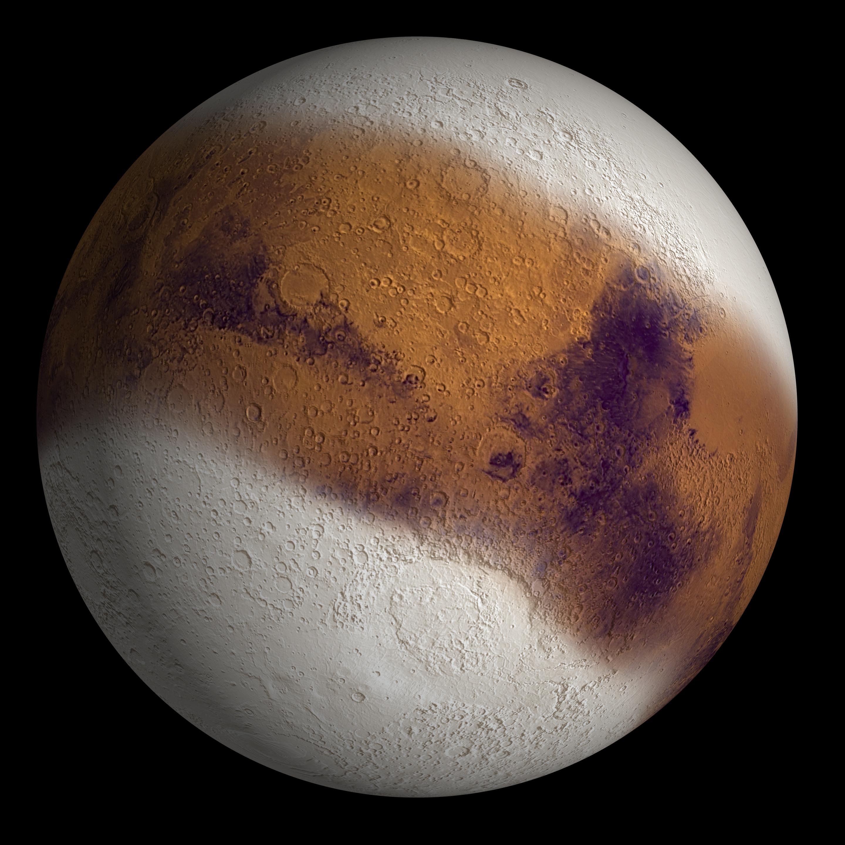
In 2001 planetary geologists Kathryn Fishbaugh, James Head and David Marchant outlined evidence for a glacial retreat of the north polar cap, including evidence of glacial moraines, sedimentation at the margins, and drainage channels they found associated within the Olympia Depression. The researchers cited that the retreat of the polar cap had likely occurred in recent geological time during the Late Amazonian. However, I did not read mention by them of the evidence for glacial ice contained in the dark collar. The most recent scientific reports focus on the potential of regions on Mars that may show evidence for subsurface frozen lakes or oceans. However, I wondered if the "dark collar" in the northern hemisphere was perhaps the largest single piece of evidence for an ancient retreating glacier from the previous ice age.
It would be just thick enough so that it would prevent the ice beneath from being directly observed. The debris lying on top of the glacier would also thermally protect the ice from summertime sublimation. By comparing features found in the dark collar area to the light-toned plains just below, several immediate distinctions can be made. 1) Few cracks, crevices, or partially buried craters are seen in the lighter plains areas. 2) The ratio of dust devil tracks in the dark collar areas are on the order of many magnitudes greater than those in the light toned areas. 3) The cracks, fissures, crevices and partially buried craters appear to abruptly stop when you get to about 67 degrees north latitude. If the dark collar is the remnant of a an ancient receding glacier, then why does it only occur between 50 - 65 degrees North? Why did it not continue all the way up to the polar ice cap? Looking at a map between 67 degrees north latitude and where the dark polar ice cap deposits begins, the terrain is comprised mainly of a lighter-toned surface material where few, if any cracks, crevices, moraines, or other features that are found in the dark collar can be seen. Related Links SpaceDaily Search SpaceDaily Subscribe To SpaceDaily Express  Los Angeles (SPX) Feb 24, 2005
An article in the New Scientist reports that a team of scientists working on the European Mars Express orbiter have found evidence of large amounts of pack ice lying within a few centimters of the Martian surface in parts of the planet's equatorial regions.
|
| ||||||||||||
| The content herein, unless otherwise known to be public domain, are Copyright 1995-2016 - Space Media Network. All websites are published in Australia and are solely subject to Australian law and governed by Fair Use principals for news reporting and research purposes. AFP, UPI and IANS news wire stories are copyright Agence France-Presse, United Press International and Indo-Asia News Service. ESA news reports are copyright European Space Agency. All NASA sourced material is public domain. Additional copyrights may apply in whole or part to other bona fide parties. Advertising does not imply endorsement, agreement or approval of any opinions, statements or information provided by Space Media Network on any Web page published or hosted by Space Media Network. Privacy Statement All images and articles appearing on Space Media Network have been edited or digitally altered in some way. Any requests to remove copyright material will be acted upon in a timely and appropriate manner. Any attempt to extort money from Space Media Network will be ignored and reported to Australian Law Enforcement Agencies as a potential case of financial fraud involving the use of a telephonic carriage device or postal service. |