| . |  |
. |
White Cliffs - Apr 16, 2004 If you find layered sediments, they do not have to be either water-transported or the outpourings of volcanoes. They may be aeolian, that is, wind-blown. On Mars, they may also be a bit strange. Those are simple facts that the Martian Wet Worlders seem to generally forget, or, more to the point, resolutely ignore. Those good folk will not contemplate the simple proposition that the surface of Mars has mostly been shaped by wind-driven erosion and transport. They have this blind spot because they have invested so heavily in the notion that Mars had rivers and oceans of liquid water long ago, and the wetter and warmer past climate needed to make that possible. Here then, in counterpoint, is the Long-winded Model of Mars. This model may account for the enigmatic layered beds of Mars and the canyons and channels they cut them, without invoking unlikely past wetter and warmer climates. I do not claim that it is right in detail, I merely propose that it is likely to be closer to the mark than the Wet World model. Some of the canyons and chasms of Mars, particularly the larger ones, are clearly tectonically controlled, that is, they are pull-apart features reflecting deep-seated crustal stresses. This model attempts to explain the rest. It requires only the present climate and surface geology and lots of time. I do not propose that the present climate has always been what it is; that is clearly not likely. I merely propose that if we do not have a clue about past climates, we do not need to propose exotic early models, designed to account for evidence that can be adequately explained by things as they now are. The sedimentary and erosion processes outlined below will have operated unevenly over time; huge meteoritic impacts and the vast volcanoes prove that considerable quantities of energy have been released suddenly in the past. Those and other sporadic energy releases would have triggered considerable erosion, transport and deposition. The bulk of the observed sediments and the channels that cut them may hence be very old, and they very likely formed mainly in relatively short time-bursts, but my contention is that the processes involved can still be observed operating now. This model builds on Nick Hoffman's White Mars one (Hoffman, 2000), by slightly modifying and extending (or eroding?)that picture. In his detailed and seminal model Hoffman proposed that huge outburst floods created the observed canyons, and that those outbursts were lubricated by liquid carbon dioxide from underground reservoirs and not by water. He stated that in the White Mars model the flows are not sourced from volcanic vents, but from the collapse of thick layered regolith containing liquid CO2, to form zones of chaotic terrain. Huge outburst floods are a favourite with both camps in this debate - the lone eccentric being myself? The planet shows ample evidence of what appear at first viewing to be such huge and sudden flows of fluids, starting at the heads of well-defined channels, and then moving down them. My objection is the flows may well have been huge but were probably not sudden or singular. What was and is being moved, is predominantly very fine dust, shifting under low gravity. I contend you can cheerfully generate all the flow lines, tear-drop islands, eroded mesas and depositional lobes you can find, merely with katabatic airflows and the associated fluid-bed dynamics proposed below, repeating again and again, over aeons of time. Mars has not, for a very long time, if ever, had active plate tectonics, with the associated mountain building, erosion and re-surfacing that we have here. There is vastly more time on Mars for the undisturbed development of such things as erosion channels and canyons, than there ever has been here. I wish to first address Hoffman's proposed "thick layered regolith." I have no objection to it, it is a cautiously broad and so a very proper description, but we may make some progress if we hazard a further guess as to its origin and nature. We frequently see huge dust storms on Mars, clearly moving huge amounts of fine material. As the planet is assumed to have a mainly basaltic crust, I will assume, till better evidence is to hand, that the bulk of the observed dust is fine degraded basalt. Is thereanything else significant in those dust clouds? Perhaps. The martian atmosphere is about 98% carbon dioxide at about 7 millibars, close to the surface. That pressure is suspiciously close to the triple-point pressure of water, suggesting that water, probably as ice or clathrate in the ground, is controlling it. Be that as it may, in the martian atmosphere, CO2 is far and away the dominant gas, and is very close to its freezing point, as the appearance of CO2 snow at the poles, increasing in winter and diminishing in spring, clearly shows. The main source of heat on the planet is the distant sun, so it is clear that, within the martian dust storms, and particularly in the lower atmospheric layers within those storms, temperatures will drop considerably when dust obscures the sun. It will temporarily insulate the air and ground against incoming solar heat. So, it will snow CO2 within the dust cloud. Dry ice will fall to the ground, together with fine dust in copious quantities, as much of the shrouded atmosphere will freeze. We are not used, on this planet, to an atmosphere that freezes almost totally, only to one in which the very small and highly variable component that is water (absolute maximum 4.2%), actually freezes. To imagine roughly what happens on Mars, you have to picture almost all the 78% of our atmosphere that is nitrogen, plus the 21% oxygen, plus the water, freezing out on a (very) cold day. If all that's reasonable, and we wish to further understand the vast plains of Mars, we should perhaps pay far more attention, to the sediments at and near the poles. They will be essentially similar to the rest, but just contain more dry ice and less dust. If there was no dust in the polar air when it snowed on a particular day, that day's polar sediment will be clean; if there was a dust storm, the result will be a variable analog of the sediments found away from the poles. In the lower latitudes, there may be enough dry-ice snow inthe mixture, for the dust grains to be surrounded and supported by that ice, rather than by other dust grains. This is critical. If the deposited mixture is buried deeply enough, when the storms pass, if the dry ice is not again warmed sufficiently to sublimate, a layered sequence of ice-supported sediments will gradually build up. It will be generally stable for a very long time, but not quite forever. One day it will become very unstable. Instability will come when the lithostatic pressure on a particular stratum, slowly increasing as the overlying sediments thicken, reaches about 5 bar. Under present conditions that means about 500 metres or thereabouts, in ground towards the equator, given the present atmosphere and temperatures (Hoffman. Op cit.). At that point the dry ice will melt. In an undisturbed large plain, the liquid will not be able to escape, as it will remain trapped below the overlying, still-frozen sediments. But near the head of an existing canyon, the liquid carbon dioxide will escape into the canyon head, either as a liquid or as an evaporating gas, because in that direction, the lithostatic pressure declines to zero in the free air. So, losing a large part of its original volume, the sediment will collapse, giving the chaotic terrain observed at the head of so many canyons (Hoffman, op. Cit. Again). So the canyons will extend by progressive headward extension. This allows a prediction, always a desirable but dangerous thing with a new hypothesis. None of the canyons or channels that have formed the way I suggest, I think, should be less than about 500 metres deep, at any point. There should also be no chaotic collapse-terrain either, where the sediment was not at least that thick, prior to collapse. Further, the heads of all such channels, in particular, should not be much deeper than 500 metres approximately, either. That should be easy to check, though I cannot do it from this antique pc. If any of the channel heads are deeper, some other mechanism must be in play in that case, such as deep-seated tectonic forces. The premier example, obviously, is the Vallis Marineris. The significance of the fact that such chaotic collapsed terrain is still there to be observed at the heads of any of the channels at all, has been missed. It is here that I will part company with Hoffman's model. The lithic material is still there after the collapse; it does not hurtle down the canyon for a few hundred or a thousand kilometres or so, in one great rolling gas-supported wave, in my opinion. I suspect it collapses, loses its gas component straight off, moves some little distance if at all, and then the dust just gradually blows away, down the channel, having almost all the time on Mars to do so. There are some chaotic collapse terrains where it is absolutely clear that lithic material has yet moved en masse. The ground has collapsed, but the lithic part of the sediment is still there and the collapsed area has no surface linkage as yet to the canyon head, just a very little way off. Cold air sinks, so that whenever the martian atmosphere is stirred, such air will sink into and flow along the canyons and channels. Almost every such conduit shows exactly how the dust from collapsed areas that are linked directly to the canyon, which is the vast majority of them, is moved away; they are almost all lined with endless columns of barchan dunes, fresh as daisies. These generally march in single file right down the middle of the channel, with no idle meandering about to take time off to undercut the edges of the cliffs, as water flows do. Sometimes the dunes march in double file, and sometimes they march straight up side-tributaries and clean out of their channels, exactly as water does not. When the dust finally reaches the open plains, it simply blows away. The position of the heads of the channels, and of the chaotic collapse terrains, may give us a sort of rough guide for the 500 metre isopac (thickness contour) for the edges of the sedimentary plains. If the system is active and healthy, the channel heads will, I think, give or take a lot of interference from bedrock, stay about the same depth-distance back from the sedimentary "coastline." As more fine wind-blown material is deposited on the plains and those plains very slowly advance over bedrock and deepen, the line linking the heads of the channels should slowly creep, in step with, but many kilometres behind the dust shoreline, into the fringing bedrock hills. Are oceans on Mars a useful concept? Sure, but of dust always, and of water, never. The loss of volatiles from the plains of Mars, as proposed, may well contribute to lateral shrinkage as well as vertical compaction. That may help produce the observed large tension cracks, otherwise known as chasms or canyons. De-gassing and such lateral shrinkage of entire sediment sheets, could act in tandem with deep or sudden tectonic forces, to extend the canyons headwards. The latter would help deal admirably with the sediment-budget paradox, i.e. where have all the rock-flours gone, long time passing? Answer, partly sideways. The incised canyons and channels are perhaps not the only places on the martian plains where long-buried CO2 escapes. In sedimentary terrain uncut by such channels, vents are likely to be point sources, leading to neat round collapse-craters, of which there is no shortage of candidates. To date almost all have been regarded as meteorite impact sites. As the density of such presumed impact sites in any given region is almost the sole basis for the current geochronology of Mars, if so, that complex intellectual edifice can go straight to the dustbin. Many craters show what look like plumes of white material, clouds of re-freezing dry ice, is my guess, blowing away, almost certainly downwind, at sunrise. Many craters show central mounds that may well be escaped ultra-fine dust, brought up by this presumed venting carbon dioxide. It should be kept in mind that such venting may in part be cyclic. Where dry ice in near-surface sediments does not separate and support the accompanying dust grains, after temporary pressure changes cause some gas to blow off, when the pressure reverts to its previous level, the voids will still be there and will be re-filled as before. When temperatures drop at night or in winter, the air will again freeze. That, process, oft repeated, may explain the neat round holes or perhaps tubes recently detected by the Spirit lander's micro-camera, if the rocks in which they occur do turn out to be sediments. Such re-freezing and sublimating will not cause the sort of surface heaving that we see in the permafrost here, as on freezing, carbon dioxide does not expand as water does. The size and depth of a crater formed by such de-gassing as proposed may indicate the depth of the venting stratum. Again, 500 metres should be some sort of optimum, and should give a statistically-significant peak in crater size distribution. Another dangerous, testable prediction. Craters well over any such size-optimum, and of course all those showing solid rock ejecta, are likely to be from genuine incoming missiles. Those showing splosh blankets may prove be either. If de-gassing in a particular case carries significant amounts of fine dust with it, up and over the crater rim, that would deposit just over that rim, and with repeated pulses, could over time form the observed blankets of deposited material. A single meteorite, striking unstable sediments, could do the same. One particular crater shows its entire rim collapsing inwards in a neat ring. That may indicate a deeper layer venting after a shallower one, rather than an exact bullseye by a second meteorite. If these craters are all meteorite impact sites, why are they not more evenly distributed across the planet? They seem to target the big sedimentary plains preferentially. Dry ice, in an unstable, partially sublimated state, or a dry ice-water ice clathrate, a few inches below the surface, would also seem the most likely explanation for the mud-like marks caused by the dragging of Spirit's landing gear, termed "the magic carpet." Those marks have been the cause of much excitement among the geological wets, but they do not necessarily indicate the sediment was slushy with liquid. A loose mix of dust and ice crystals would do it. The canyons repeatedly show a layer of rock, not far below the surface, that is competent enough, when undercut, to roll down the canyon sides, as blocks up to the size of houses. So, the larger meteorite-impact craters should show large chunks of such rock, hurled out of and littering the ground around themselves. The resolution on the European Mars Express camera, down to 2 metres, is well sufficient to show such rocks, so we should see them soon. If they prove to be ubiquitous, or nearly so, I am clearly wrong about some of the craters being de-gassing and not impact features. One key question in this debate is, do any large boulders move long distances down the channels? If they do, are there extensive and widespread beds of them, jammed together at points along the channel floors where transport energy slacked and they got stuck? That, on the evidence so far, seems not to be the case. That the beds of the closely observed channels are littered with scattered boulders, is no problem. At what seems to be a remarkable even depth below the surface on both canyon and crater walls, a hard, generally though not always, single layer of material forms cliffs, and house-sized boulders tumble down from it at many points, as mentioned. These points together suggest a secondary laterite of some sort. There is water in the atmosphere, and there is water ice on the surface at he poles, and there is that water triple-point and atmospheric pressure coincidence. Water ice close to the surface, either free or as a clathrate, on either melting or sublimation, will react chemically with iron and aluminium-rich dust (which describes basaltic dust to a tee), to give iron and aluminium oxides, that is, laterites and bauxites. Even should it prove to be a volcanic layer, either of lava or of secondarily-hardened ash, the case is not materially altered. There are enough boulders, either way, to litter the collapsed chaotic terrains at the channel heads, and to roll down the side slopes of the channels, and litter the channel floors at all points, as seen. Also, if boulders from the channel sides tumble down onto dunes or other dustlayers below, they will be gradually moved some distance down-channel. As dust on their downwind sides is blown away, they will creep along down-channel until they reach bedrock, when they will probably stop permanently. If, on the other hand, huge and catastrophic flows of water or other fluids, such as the CO2-driven turbidite or nuee-ardente analogs proposed by Nick Hoffman, ever raced down the length of the channels, something else is predictable. Namely, that there should be vast and disproportionate piles of boulders, cobbles and pebbles at least along their length, if not at their ends, that is, at their deltas. We have not found them yet, and I, obviously, do not think we will. It may be found that the boulders and cobbles seen by the landers, whether they turn out to be primary igneous or volcanic rocks, or secondary laterites, have not moved far from their place of formation. However, if they have, the long-winded model can cope. Katabatic flows of cold air within dust storms and on canyon floors may generate a fluid-bed system, with friction melting or sublimating or merely rounding the dry ice crystals, to produce millions of temporary ball-bearings, giving flows strong enough to move rocks downstream in pulses. So perhaps they have moved, but again, liquid water is a superfluous luxury. The proposed model copes with the apparent total lack of martian sea cliffs, wavecut platforms, boulder and cobble beaches and spits, touching boulder beds in the rivers, undersea canyons, major tributaries, deltas and coastal dune fields. It copes with the glaring absence of carbonate rocks, on a planet with an embarrassing abundance of the ingredients needed, if there ever was a lot of liquid water about. It also copes with impossible physics, impossible chemistry, impossible water and sediment budgets, rivers that apparently ran several kilometres uphill or up their own minor tributaries. It deals with vistas of "river" boulders at landing sites that have very clearly been seriously wind-sculpted, and which decline to touch each other with almost paranoid dedication. It handles the faint-young-sun paradox, which mandates a colder past Martian surface. It also deals with a brand-new paradox. On the floor of the Ganges Chasma, the orbiting Themis instrument recently detected olivine, a mineral that cannot persist for any length of time under water.
Related Links SpaceDaily Search SpaceDaily Subscribe To SpaceDaily Express 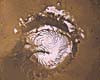 Tucson AZ - Mar 26, 2004
The spiral troughs of Mars' polar ice caps have been called the most enigmatic landforms in the solar system. The deep canyons spiraling out from the Red Planet's North and South poles cover hundreds of miles. No other planet has such structures.
|
| ||||||||||
| The content herein, unless otherwise known to be public domain, are Copyright 1995-2016 - Space Media Network. All websites are published in Australia and are solely subject to Australian law and governed by Fair Use principals for news reporting and research purposes. AFP, UPI and IANS news wire stories are copyright Agence France-Presse, United Press International and Indo-Asia News Service. ESA news reports are copyright European Space Agency. All NASA sourced material is public domain. Additional copyrights may apply in whole or part to other bona fide parties. Advertising does not imply endorsement, agreement or approval of any opinions, statements or information provided by Space Media Network on any Web page published or hosted by Space Media Network. Privacy Statement All images and articles appearing on Space Media Network have been edited or digitally altered in some way. Any requests to remove copyright material will be acted upon in a timely and appropriate manner. Any attempt to extort money from Space Media Network will be ignored and reported to Australian Law Enforcement Agencies as a potential case of financial fraud involving the use of a telephonic carriage device or postal service. |