| . |  |
. |
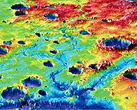
St. Louis - Nov 26, 2001 An analysis of high-resolution topographic maps and photographs, as well as recent studies of Martian meteorites suggest the presence of water on the Red Planet for a longer time scale than scientists had previously believed. Brian M. Hynek, doctoral candidate in earth and planetary sciences in Arts & Sciences at Washington University in St. Louis, and Roger J. Phillips, Ph.D., professor of earth and planetary sciences and Director of Washington University's McDonnell Center for the Space Sciences, analyzed topographic maps of the planet (accurate to within half a meter) that are based on data returned from the Mars Orbiter Laser Altimeter (MOLA) on the Mars Global Surveyor (MGS) mission. Phillips also used earlier analyses of Martian meteorites to help constrain models of the ancient climate of Mars. The meteorites contain weathering deposits produced from liquid water filling cracks and voids in the rock within the last billion years. This work led to a better understanding of when, and how much, water was on Mars in the past. "Certainly water was circulating in the upper part of the Martian crust within the last billion years," said Hynek. "And even until today, water seems to be an important agent in some places on the surface of Mars that would argue for very near surface water on a lot of the planet." A recent discovery by the imaging camera team on MGS indicates the presence of small gullies at high latitudes on Mars that were formed in the very recent past and may still be active today. Phillips and his colleague, Michael Mellon, Ph.D., of the University of Colorado, modeled the properties of Martian soil and concluded that the gullies were probably formed by liquid water, which may be present only several hundred feet beneath the surface Mars. This work was published in the October Journal of Geophysical Research. The research was presented on Nov. 7 in an invited talk for the 113th annual meeting of the Geological Society of America. The research is primarily supported by NASA grants. Evidence for the ancient presence of water on Mars has existed for many years. Scientists long have accepted the river valley networks, ancient lakes, and outflow channels as indicative of surface water flowing at some time in the planet's four-billion-old plus history. "There has always been evidence from very ancient valley networks that water was there at some time extremely early on," Hynek said. "But new evidence from meteorites, young gullies, and better topographic resolution is helping to clarify a more precise time frame for water on the planet." Hynek and Phillips focused some of their analysis in two predominant regions of Mars, the Tharsis rise and the Arabia bulge. The Tharsis rise dominates the western hemisphere of Mars. It is a broad, elevated region rising up to 10 kilometers above its surroundings and encompassing over 30 million square kilometers. The rise is the site of large-scale volcanism and extensive fracturing of the crust. Due to the extreme pressure of this rise on the planet's surface, the opposite side of Mars bulges outward, causing a deformation known as the Arabia bulge. River valley networks flow all over the Arabia bulge. The prevailing theory is that these intricate networks represent evidence for water once flowing on the surface of Mars. Although researchers have known about these formations for many years, they had no idea of their greater significance until they looked at the high-resolution topographic map. "Most of the valley networks flow downhill from the bulge, and this argues that the valley networks follow the topography induced by the massive load of Tharsis," Hynek explained. According to Hynek, the valley networks came after Tharsis warped the planet because they are following the topography formed by Tharsis. The argument is that during emplacement, or formation, of Tharsis approximately 4 billion years ago, volatiles from volcanoes probably created an atmosphere that would have led to a hydrogeologic cycle to help form the valley networks. This work was reported in the journal Science earlier this year. "MOLA data are starting to put together a coherent picture of early Mars that couldn't be done or tested before," Hynek said.
The search for definitive evidence of water represents a focus in a NASA debate over proposed landing sites for the 2003 rover mission to the planet. Hynek and Phillips are involved in the landing site selection process for the mission. Their recent research has involved the analysis of a top candidate landing site that has distinctive minerals, which may be indicative of extensive water. Geologic mapping of the deposit, combined with topographic and compositional analyses, has helped to constrain how and when it formed. "It is likely that these materials formed in middle Martian history, possibly from the circulation of groundwater or hydrothermal springs," Hynek said. This is additional evidence for a long-lived history of water on Mars. Hynek noted that this unique region of Mars would almost certainly be chosen for the 2003 mission. "The battle cry for the upcoming rover mission is: 'Follow the water'," Hynek said. Related Links Washington University in St. Louis McDonnell Center for the Space Sciences Mars MOLA Data SpaceDaily Search SpaceDaily Subscribe To SpaceDaily Express  by Dr Nick Hoffman
Melbourne - Oct 23, 2001 The main evidence for liquid water on Mars is the past development of giant flood channels that have been seen for the last 25 years as proof of the escape of water from the subsurface. All the models for modern and ancient Mars are based on the premise that there was once liquid water available, and perhaps even an ocean.
|
| |||||||||||
| The content herein, unless otherwise known to be public domain, are Copyright 1995-2016 - Space Media Network. All websites are published in Australia and are solely subject to Australian law and governed by Fair Use principals for news reporting and research purposes. AFP, UPI and IANS news wire stories are copyright Agence France-Presse, United Press International and Indo-Asia News Service. ESA news reports are copyright European Space Agency. All NASA sourced material is public domain. Additional copyrights may apply in whole or part to other bona fide parties. Advertising does not imply endorsement, agreement or approval of any opinions, statements or information provided by Space Media Network on any Web page published or hosted by Space Media Network. Privacy Statement All images and articles appearing on Space Media Network have been edited or digitally altered in some way. Any requests to remove copyright material will be acted upon in a timely and appropriate manner. Any attempt to extort money from Space Media Network will be ignored and reported to Australian Law Enforcement Agencies as a potential case of financial fraud involving the use of a telephonic carriage device or postal service. |