| . |  |
. |
|
The Tharsis Montes
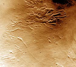
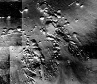
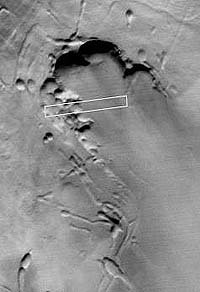
Reykjavik - June 5, 2001 Arsia Mons (figures 3 and 4) The Northeast segment of Arsia Mons as shown in figure 3 is a segment that differs considerably from the SW segment in having one advanced valley system and extending into the caldera. The upper segment is made up of a few but well developed elongated depressions. Some of the segments in between such depressions have the shape of "islands" or mountains. As on the SW side their height increases up-dip. Characteristic of the ring shaped depressions is the lack of an ash collar, as if the depressions formed in response to melting of a subsurface layer. There are clear differences between the northeast and southwest valley systems in that the northeast system is lower and extends morphologically into the caldera. The caldera opens up on the northeast side. Thus, it is plausible that melt-water generated by interaction of magma and ice within the caldera may preferably have been released or leaked through the northeast gate. This may explain the much higher degree of erosion there and more highly developed valley system. Southwest segment (figure 4). In the southwest system large ring-shaped collapse structures are more abundant and the narrow elongated depressions are less well developed. Below the circular depressions the valley system opens up and is made up of two branches. The eastern branch, is more extensive and here the valley is fairly well developed but with a central threshold midway up dip. On the lower flanks of the eastern branch linear features are observed, probably volcanic fissures, extending up-dip into the volcano sides. The western branch is less well developed and can be defined as being at an intermediate stage between a valley and ring depression. Two notable features occur that are altitude dependant. The first is that up-dip the valley walls become higher. The second is that the ring-shaped depression have a greater diameter up-dip.
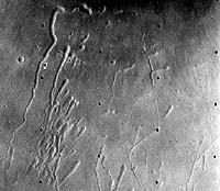
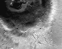
Pavonis Mons erosional valley system: Southwest segment. Looking at the systems respectively on the southwest and northeast flanks of Pavonis Mons (figures 5 and 6) individual depressions within the southwest segment (figure 5) are characterized by a near-circular, upper terminus - from which extends a graben like depression that becomes narrower down-dip. Down-dip the depression tails are intertwined forming a network or irregular relief. This segment is regarded at an early evolutionary stage.
Northeast segment. Conversely, a nearly complete erosional valley is exposed on the northeast segment (e.g. Viking Orbiter Frame 643A54). Here a 25 km broad valley has formed with up to 2 km high horse shoe-shaped cliff walls. No "islands" or ridges are exposed on the valley floor. The erosion extends down into the concentric fissure system in front of the valley (see location on figures 5 and 6). At location A (figure 5) the ridges between the depressions have been eroded and the direction of erosive medium is clearly down-dip.
Fortunately, the Mars Global Observer captured an image of the valley floor that extends into the valley walls. The location of this image within the valley is given on figure 7. The image on figure 8 (MO401369) shows that the valley floor is riddled with small impact crater remnants. The larger of the crater remnants have "black eye" crater center. The image shows hundreds of still smaller remnants. Erosion has consistently acted on the remnants in a down-dip direction to the extent that there is an up-dip head and a down-dip tail. For the crater remnants direction of tail extension is perfectly parallel. A darker colored sediment, probably of air-borne origin, is draped over the valley floor. Its pattern runs obliquely with that of the erosional direction.
On the valley floor there occur exceptional pristine impact craters. It is important to note that the ratio of young pristine craters to older crater remnants is at least 1/100. It is concluded that the crater remnants on the valley floor were deformed through extensive fluid flow originating up-dip. Hartmann et al., concluded that the youngest surfaces they detected on Arsia Mons were 40-100 million years and extrapolating their results for Pavonis Mons the age of the valley floor and thus the age of the latest erosive event there is very recent and must be well within 10 million years. This implies that Pavonis Mons is presently highly volcanically active.
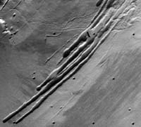
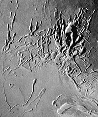
Within the fault-bounded terraces of the valley walls, however, no indication of crater erosion is noted. Sediment deposition (apparently wind blown) is, however, substantial. The mechanism most likely responsible for the valley floor erosion is that of jokulhlaups. In this case the source of fluid would presumably be located within the Pavonis Mons caldera (Helgason, 2000, 2001). The erosional valley is here considered to be the locus or path through which all jokulhlaups must travel en route from the northeast side of the caldera or perhaps from the entire caldera. That would explain why the northeast valley system is so extensively eroded. Ascraeus Mons erosional valley system (figures 9 and 10): Southwest segment. This segment (figure 9) is well evolved with a multitude of narrow depressions of irregular shape, width and length. Collapse features are mainly located on concentric fault lines. The elongated depressions extend down-dip across the concentric fault system. On Viking image F647A78 (figure 9) extensional faults cutting across the concentric faults are not observed. Erosion is advanced within the main valley system with a prominent "island" at the center. The valley walls are highly irregular. Outside the valley system, i.e. within the fan area the surface is predominantly smooth with local "second generation" depressions. There are striking similarities between the southwest segment of Ascraeus Mons and the northeast segment of Arsia Mons.
Northeast segment. The northeast segment (figure 10) has a few elongated depressions. A central valley is not observed (Viking Orbiter Frame F648A30). Instead collapse features, both of the isolated ring-shaped type as well as elongated tail-like collapse kind, are scattered over a wide area. Ring-shaped collapse structures: Some of the ring shaped structures on the southwest side of Arsia Mons are up to 6 km in diameter with a depth of 1 km. In Iceland ring-shaped collapse craters are common within basalt lava shields. The largest of such craters is Stora-Viti, 1 km in diameter and 100 m deep. Icelandic collapse craters have near vertical walls resembling a cylinder. Conversely, Martian collapse craters have gently inclined walls and the smaller of such craters have the shape of an overturned cone. Craters in excess of 5 km in diameter have a flat bottom. While collapse craters in Iceland are associated with lava extrusion the Martian craters here referred to lack such a relationship. This comparison suggests that a different mechanism is responsible for the formation of the Martian craters. The suggested mechanism for these Martian collapse craters is one of magma contact with a subsurface ice layer. The melting and eventual release of melt-water may have led to extensive subsurface melting and release of melt-water, resulting in the formation and growth of collapse craters at the surface.
|
| |||||||||||||||||
| The content herein, unless otherwise known to be public domain, are Copyright 1995-2016 - Space Media Network. All websites are published in Australia and are solely subject to Australian law and governed by Fair Use principals for news reporting and research purposes. AFP, UPI and IANS news wire stories are copyright Agence France-Presse, United Press International and Indo-Asia News Service. ESA news reports are copyright European Space Agency. All NASA sourced material is public domain. Additional copyrights may apply in whole or part to other bona fide parties. Advertising does not imply endorsement, agreement or approval of any opinions, statements or information provided by Space Media Network on any Web page published or hosted by Space Media Network. Privacy Statement All images and articles appearing on Space Media Network have been edited or digitally altered in some way. Any requests to remove copyright material will be acted upon in a timely and appropriate manner. Any attempt to extort money from Space Media Network will be ignored and reported to Australian Law Enforcement Agencies as a potential case of financial fraud involving the use of a telephonic carriage device or postal service. |