| . |  |
. |
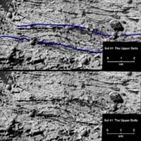
NASA today released details on news findings on Mars that point to the first strong evidence that a sea once covered part of Mars in the Meridiani Planum area where Mars Exploration Rover Opportunity is currrently exploring. In an announcement made Tuesday in Washington, NASA officials sais Earth might not be the only planet in our solar system to have hosted salty seas. NASA's Opportunity has uncovered evidence that the rocks near its landing site on Mars not only were once wet, but likely formed at the bottom of a body of gently flowing saltwater. "We think Opportunity is now parked on what was once the shoreline of a salty sea on Mars," said Dr. Steve Squyres of Cornell University, Ithaca, N.Y., principal investigator for the science payload on Opportunity and its twin Mars Exploration Rover, Spirit. Dr. Ed Weiler, NASA associate administrator for space science, said, "This dramatic confirmation of surface water in Mars' history builds on a progression of discoveries about that most Earthlike of alien planets. This result gives us impetus to expand our ambitious program of exploring Mars to learn whether microbes have ever lived there and ultimately whether we can." Rippled patterns in the rocks at Meridiani Planum suggest that the land there was once a salt flat or playa, sometimes covered by shallow water and sometimes dry, said Dr. John Grotzinger, rover science-team member from the Massachusetts Institute of Technology, Cambridge. Such environments on Earth, either at the edge of oceans or in desert basins, can have currents of water that produce the type of ripples seen in the Mars rocks. According to Grotzinger, the sand-sized grains of sediment making up the rocks were shaped into ripples by water at least 5 centimeters (2 inches) deep -- possibly much deeper -- and flowing at a speed in the range of 10 to 50 centimeters (4 to 20 inches) per second. Telltale patterns called crossbedding and festooning, in which some layers within a rock lie at angles to the main layers, led scientists to the conclusion that the rippled shapes formed under a current of water -- and not wind. Festooned layers have smile-shaped curves that are produced when loose sediments are shifted by water. "Ripples that formed in wind look different than ripples formed in water," Grotzinger said. Some patterns seen in the outcrop that Opportunity has been examining might have resulted from wind, but others are reliable evidence of water flow, he said. So far, the findings do not specify how long liquid water covered the area, or how long ago, but controllers at NASA's Jet Propulsion Laboratory in Pasadena, Calif., plan to send Opportunity out across the a plain toward a thicker exposure of rocks in the wall of a crater that should add to the story. A second line of evidence, observations of chlorine and bromine in the rocks, also suggests that water covered the surface when these rocks were forming. Rover scientists presented some of that news three weeks ago as evidence that the rocks had at least soaked in mineral-rich water, possibly underground water, after they formed. Increased assurance of the bromine findings strengthens the case that rock-forming particles precipitated from evaporating water as salt concentrations climbed past saturation. Dr. James Garvin, lead scientist for Mars and lunar exploration at NASA Headquarters, Washington, said, "Many features on the surface of Mars that orbiting spacecraft have revealed to us in the past three decades look like signs of liquid water, but we have never before had this definitive class of evidence from the Mars rocks themselves. We planned the Mars Exploration Rover Project to look for evidence like this, and it is succeeding better than we had any right to hope. Someday we must collect these rocks and bring them back to terrestrial laboratories to read their records for clues to the biological potential of Mars." Squyres said, "The particular type of rock Opportunity is finding, with evaporite sediments from standing water, offers excellent capability for preserving evidence of any biochemical or biological material that may have been in the water." NASA's Mars Reconnaissance Orbiter, due to launch in 2005, will survey the whole planet for sites with water-related minerals and help identify sites for future landings. JPL engineers now expect Opportunity and Spirit to operate several months longer than the rovers' initial three-month prime missions on Mars. To analyze hints of crossbedding, mission controllers programmed Opportunity to move its robotic arm more than 200 times in one day, taking 152 microscope pictures of layering in a rock called "Last Chance." Related Links Mars Rovers at JPL Mars Rovers at Cornell SpaceDaily Search SpaceDaily Subscribe To SpaceDaily Express 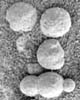 Pasadena (JPL) Mar 18, 2004
A major ingredient in small mineral spheres analyzed by NASA's Mars Exploration Rover Opportunity furthers understanding of past water at Opportunity's landing site and points to a way of determining whether the vast plains surrounding the site also have a wet history. Martian South Pole Not Just Dry Ice  Moffett Field - Mar 22, 2004
Astronomers have known for years that Mars possessed polar ice caps, but early attempts at chemical analysis suggested only that the northern cap could be composed of water ice, and the southern cap was thought to be carbon dioxide ice.
|
| ||||||||||
| The content herein, unless otherwise known to be public domain, are Copyright 1995-2016 - Space Media Network. All websites are published in Australia and are solely subject to Australian law and governed by Fair Use principals for news reporting and research purposes. AFP, UPI and IANS news wire stories are copyright Agence France-Presse, United Press International and Indo-Asia News Service. ESA news reports are copyright European Space Agency. All NASA sourced material is public domain. Additional copyrights may apply in whole or part to other bona fide parties. Advertising does not imply endorsement, agreement or approval of any opinions, statements or information provided by Space Media Network on any Web page published or hosted by Space Media Network. Privacy Statement All images and articles appearing on Space Media Network have been edited or digitally altered in some way. Any requests to remove copyright material will be acted upon in a timely and appropriate manner. Any attempt to extort money from Space Media Network will be ignored and reported to Australian Law Enforcement Agencies as a potential case of financial fraud involving the use of a telephonic carriage device or postal service. |