| . |  |
. |
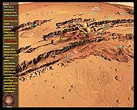
GeoFusion, Inc., a leading innovator in geospatial visualization, announces GeoPlayer Mars, created with the high performance GeoMatrix Toolkit technology. This Interactive 3D Demo allows users to interactively fly around the planet of Mars which is comprised of global imagery and terrain derived from NASA/JPL data. Users can explore mission landing sites and the amazing craters, canyons, and volcanoes or be taken on automatic tours. This is a lower resolution version of GeoFusion's Mars exhibit currently at the National Geographic Museum at Explorer's Hall in Washington, D.C. The GeoMatrix Toolkit is a C++ Software Development Kit (SDK) that provides an object oriented Application Programmer's Interface (API) enabling software developers to build interactive full-globe geo-referenced applications. The toolkit is a complete development environment that includes modular libraries, example applications with source code, and documentation. GeoFusion licenses the GeoMatrix Toolkit SDK for building digital Earth and other planetary visualization applications. Markets include Internet, GIS, education, entertainment, real-time terrain visualization and homeland defense. GeoFusion's software technology provides the engine and infrastructure for doing high performance global visualization of virtually unlimited amounts of imagery, terrain, vector, and annotation data. It provides an engine capable of displaying vast amounts of heterogeneous geospatial information which is shown in a global context while allowing for interactive zooming into complex visually stunning scenes. It allows one to obtain a new meaning of information through innovative ways of layering, animating and blending together different types of geospatial information derived from maps, satellite & aerial imagery, terrain, annotation, and vector data. This is the same technology GeoFusion licensed to ESRI to power their new ArcGlobe product. Related Links MarsDemo Free Download - 32MB SpaceDaily Search SpaceDaily Subscribe To SpaceDaily Express  Houston - Mar 30, 2004
Terraforming other worlds may take decades to accomplish, and the go-ahead may still be centuries away. So why does such a far-out topic deserve an entire book? What possible value could such a book have asks Jim Oberg.
|
| ||||||||||
| The content herein, unless otherwise known to be public domain, are Copyright 1995-2016 - Space Media Network. All websites are published in Australia and are solely subject to Australian law and governed by Fair Use principals for news reporting and research purposes. AFP, UPI and IANS news wire stories are copyright Agence France-Presse, United Press International and Indo-Asia News Service. ESA news reports are copyright European Space Agency. All NASA sourced material is public domain. Additional copyrights may apply in whole or part to other bona fide parties. Advertising does not imply endorsement, agreement or approval of any opinions, statements or information provided by Space Media Network on any Web page published or hosted by Space Media Network. Privacy Statement All images and articles appearing on Space Media Network have been edited or digitally altered in some way. Any requests to remove copyright material will be acted upon in a timely and appropriate manner. Any attempt to extort money from Space Media Network will be ignored and reported to Australian Law Enforcement Agencies as a potential case of financial fraud involving the use of a telephonic carriage device or postal service. |