| . |  |
. |
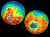
Cameron Park - May 1, 2001 At variance to the standard model of an older wet Mars, is a model as favored by Dr. Victor Baker -- who finds evidence for occasional brief warm episodes triggered by near-surface volcanism. The warmth of this volcanism was able, says Baker, to break down the carbonates where upon additional CO2 stored in the planet's cold subsurface soil and rocks was released, which when combined with thawed subsurface water ice was enough to restore Mars to its hospitable glory days for a few tens of thousands of years. A romantic picture - yes - but there are some critical problems with it. Firstly Mars, even in its earliest days, was damned cold, especially since the Sun was only about 70% as bright 4 billion years ago as it is now. Even given the greenhouse effect from a dense CO2 atmosphere, it's rather hard to visualize ancient Mars' surface being above freezing -- save, perhaps, in local volcanically heated areas, which may explain why its valley networks are quite rare compared to Earth's ancient riverbeds and seem to be concentrated in some areas. When viewed in detail, they also look somewhat different from dried-up riverbeds on Earth -- for instance, they seem to have far fewer small upper tributaries draining into them. And for this reason, many geologists think they were carved not by surface flows of water but by much slower trickles of water a short distance underground, which gradually eroded a bigger and bigger underground tunnel until the roof finally fell in. This process, called "sapping", requires a lot less water, and it would also be produced more easily by underground geothermal heat than surface flows of water would be. There's also the puzzle of those huge catastrophic outflow channels -- were there ever really local reservoirs of high-pressure subsurface water on Mars gigantic enough to carve them? And, last but hardly least, there's an additional puzzle suspected for most of the Nineties, and dramatically confirmed by MGS when it began mapping Mars' surface minerals: the "Carbonate Paradox". Those huge surface layers of carbonate minerals which should be there today if Mars' early dense CO2 atmosphere had been destroyed that way simply aren't there -- judging by the results from MGS, the planet doesn't seem to have any major carbonate deposits anywhere on its surface at all! There are several possible explanations for this mystery. Maybe some process on Mars' surface today (there have been several proposals about this) breaks carbonates back down into CO2, so that they remain in stable deposits only a few dozen meters and more below the surface, where they were formed by the last near-surface volcanic hot springs. The dozen Mars meteorites we have on Earth today, blasted out of the planet's crust by giant meteor impacts, do contain small amounts of carbonates. Or maybe Mars actually did lose most of its air to outer space instead, thanks to giant impacts and the solar wind -- although there's some doubt as to whether those processes by themselves could have been efficient enough. A couple of scientists have even suggested that the "TES" thermal-IR spectrometer that MGS uses to map Mars' minerals is much less sensitive to carbonates than had been thought. But it is still one of the biggest puzzles about Mars. As you might expect, these puzzles were subjects of furious debate at the LPSC -- especially since, thanks to the dismal luck of the Mars probes launched since 1998, most of the recent information we've acquired on Mars comes from only one spacecraft: Mars Global Surveyor. Despite Mars Pathfinder's success and its tremendous PR value, it didn't really tell us all that much new about Mars -- which was to be expected, since Pathfinder was designed from the start as an engineering test mission. At LPSC 2001 there were many papers focusing on the exact nature of the evidence for liquid water found in the Viking orbiters' general maps of Mars' surface, the tremendously more detailed close up views of small samples of the surface from MGS' high-powered telephoto camera, and the data on Mars' mineralogy from its TES and on the exact altitude of Mars' surface features from its laser altimeter. Many of them described what looks like additional confirming evidence of ancient liquid-water features on the surface. J.M. Dohm described evidence that an "enormous drainage basin" existed during the early Noachian period, which was filled with layers of water-borne sediments that were later cut through by the growing Marineris Valley -- the gigantic system of canyons which is apparently a giant "stretch mark" produced in Mars' crust by the gradual upheaval of the huge volcanic "Tharsis Bulge" on one side of the planet. MGS has photographed dramatic rock layering all the way up the kilometers-long side of the Valley's canyons, but the majority feeling was that most of the biggest layers were solidified lava flows rather than sedimentary layers,.. Perhaps not. J.A. Grant examined the valley networks in the Margaritifer Sinus region, the area on Mars where they are most concentrated, and concluded that they were indeed carved by "sapping" (tunneling by underground water flows) rather than surface runoff -- but also that the only way such a subsurface water supply could be adequately replenished was if "widespread precipitation" in the form of rain or snow occurred in the region and then seeped into Mars' porous ground. B.M Hynek concluded from MGS' laser topography maps that the western Arabia Terra ("Arabia Highlands"), an area the size of Europe, was so eroded by surface rain that 3 million cubic km of its material was gradually washed into Mars' low-altitude northern plains. K.P. Harrison and R.E. Grimm examined the fact that the areas on Mars where valley networks seem to be most concentrated are also those where MGS' magnetic sensors -- to everyone's surprise -- found local magnetic fields which seem to be areas where crustal iron minerals have been permanently magnetized by Mars' long-vanished early magnetic field. Since this most easily occurs when molten rock is exposed to a magnetic field at the same time that it is rapidly cooled into solid form, the obvious possibility is that rising flows of underground magma may have collided in these areas with large amounts of groundwater kilometers below the surface, providing a flow of geothermal hot springs for the valley networks, and also cooling the magma quickly enough to "freeze" a copy of Mars' magnetic field into the resulting solid rock before Mars' magnetic field could reverse polarity (which, like Earth's, it probably did every million years or less) and thus scramble the permanently recorded "fossil" field. D.M. Nelson examined the highlands south of the Elysium Basin -- through which three especially big channels seem to have carried fluid for a long period -- and concluded that the area showed signs of having undergone repeated cycles of geological peace that would have allowed a local layer of ground ice to build up, and episodes of moderate volcanism just right to melt the accumulated ice and produce large water flows into Elysium. And I.E. Thorsos carried out calculations agreeing with the growing belief of geologists that volcanism wasn't the only substantial source of heat on early Mars -- the heat produced by the frequent giant impacts that gouged out the planet's craters during this "Early Bombardment" age of the young Solar System would in itself be enough to fuel "extensive hydrothermal systems". James W. Head provided several papers elaborating his belief that, during part of Mars' "Hesperian" Period -- the middle one of its three major geological periods, running roughly 3.5 to 2 billion years ago -- Mars' water-ice polar caps, which had been far bigger, were melting and shrinking back, leaving behind geological marks on the northern and (especially) the southern Martian surface that are characteristic of former glaciers. These, he says, include parallel linear gouge marks, lake beds with the unusual characteristics of big pools of meltwater underneath a thick glacial layer of ice, and "eskers" (winding ridges of sediment deposited by long-lived flows of meltwater trickling along underneath glaciers). He also claims that some southern mountains have the characteristics of ancient volcanoes that erupted underneath thick glacial ice, which would explain why the melt back occurred there. Jeffrey Kargel went farther, claiming "there are very few 100-meter-size impact craters superposed on the hypothesized glacial landscapes, indicating a relatively youthful age of one or more ancient glacial epochs. Even more surprising is the discovery of intact crevasses and gullies on some debris-covered glacier-like masses, which argues for a very recent warm climate time." Head, however, did backpedal somewhat on one of his most famous claims: that there is evidence of shoreline features running around the boundary of the great northern lowland region, which would indicate that the lowlands were filled with water during Mars' early days to make up an ocean (the "Borealis Ocean") covering one-third of the planet's surface area. T.J. Parker had previously described two such "contact features", running parallel to each other, and proposed that they were the shores of an ocean which had been filled at two different levels for long periods of time. Head, in 1999, used MGS' laser topography maps to conclude that "Contact 2" (though not "Contact 1") did indeed run at the same altitude for hundreds of km, further suggesting that a Martian "sea level" carved it. However, in his new LPSC paper, he says" Comprehensive analysis of hundreds of high-resolution [MGS] images shows little compelling evidence for features that can confidently be interpreted as shorelines... We find that evidence for oceans in the northern lowlands in the Hesperian is ambiguous; that is, it is capable of being understood in two or more possible senses. Some properties of contact 2 are consistent with the Parker hypotheses. However, [its] detailed characteristics provide little supporting evidence... This might be attributed to post-formation modification, but, nevertheless, positive supporting evidence at high resolution is not yet apparent." In his overall review of the possible course of Martian history, Bruce Jakosky agrees that the astonishingly smooth sediment plains that cover much of the northern lowlands -- which some view as the remains of an ancient seafloor -- need not be such: "Stripping of Margaritifer Sinus and Arabia Terra [by waterflows, such as I mentioned earlier] would have provided sediment to the northern plains... debris would have filled the plains to a depth of about 120 meters or more, obviating the sedimentological need for a northern ocean." Parker himself, however, is not backing down. In another new LPSC paper, he claims that many detailed features in this area look, in MGS' pictures, just like shoreline remnants along the edges of the Pleistocene-era "Lake Bonneville" in Utah, which later dried up to leave the Bonneville salt flats.
|
| ||||||||||
| The content herein, unless otherwise known to be public domain, are Copyright 1995-2016 - Space Media Network. All websites are published in Australia and are solely subject to Australian law and governed by Fair Use principals for news reporting and research purposes. AFP, UPI and IANS news wire stories are copyright Agence France-Presse, United Press International and Indo-Asia News Service. ESA news reports are copyright European Space Agency. All NASA sourced material is public domain. Additional copyrights may apply in whole or part to other bona fide parties. Advertising does not imply endorsement, agreement or approval of any opinions, statements or information provided by Space Media Network on any Web page published or hosted by Space Media Network. Privacy Statement All images and articles appearing on Space Media Network have been edited or digitally altered in some way. Any requests to remove copyright material will be acted upon in a timely and appropriate manner. Any attempt to extort money from Space Media Network will be ignored and reported to Australian Law Enforcement Agencies as a potential case of financial fraud involving the use of a telephonic carriage device or postal service. |